Overview
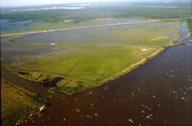
This site used to brackish marshland on the southwestern shore of Lake Pontchartrain. Bayou La Branche served as a barrier to wave action by Lake Pontchartrain. It also provided filtering of contaminants and habitat for wildlife and fish. This site was levied and pumped in the early 1900s, converting the land to use by agriculture. When a hurricane broke the levee, this site filled with water. Wetland vegetation was never able to re-establish on site due to the fact that the water was too deep to support emergent vegetation. In 1993-1994, about 2.7 million cubic yards of sediment were taken from Lake Pontchartrain and put into Bayou La Branche. This project has been successful. Approximately 305 acres of shallow water habitat has been created. Managers expect the project to favorably progress as the sediment settles further and becomes a better elevation for emergent vegetation. Monitoring continues on this site.
Quick Facts
Project Location:
St. Charles Parish, LA, USA, 29.9273657, -90.3371889
Geographic Region:
North America
Country or Territory:
United States of America
Biome:
Coastal/Marine
Ecosystem:
Estuaries, Marshes & Mangroves
Area being restored:
487 acres
Organization Type:
Governmental Body
Location
Project Stage:
Completed
Start Date:
1993-11-02
End Date:
1994-04-17
Primary Causes of Degradation
Agriculture & LivestockDegradation Description
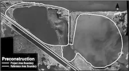
In the 1800s, the building of railroad tracks nearby created a barrier to drainage and sheetflow from the upland areas, altering the hydrology of the area. In the early 1900s the site was levied and pumped for agricultural use. This caused subsidence of the site. When a hurricane broke the levee in 1915, this former marsh became a large, open-water pond. In the 1960s, the construction of Interstate 10, adjacent to the site) altered the drainage of the area further, leading to more water flowing from Lake Pontchartrain into the site. Two hurricanes in the 1960s flooded the area further, killing even more marsh-adapted plants. Subsidence and flooding has continued through the years. Until restoration, only a very thin strip of marsh was left between the pond (which ad been marsh) and Lake Pontchartrain.
Reference Ecosystem Description
This area was a brackish marsh with emergent vegetation. This site had very little open water and supported many different types of marsh plant species. To be successful, this site will need to be filled in to a level that emergent vegetation can grow. The sediment that is put into the site will have to settle and native plants and animals will have to colonize the area.
Project Goals
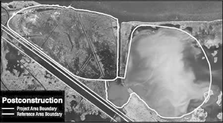
The goal for this project was to re-create the marsh that used to exist on this site. Specifically, project managers wanted to create an area of 70% land and 30% water within 5 years of construction. This would create approximately 305 acres of shallow water habitat. Once fully restored, this site will be an important buffer between the upland areas and Lake Pontchartrain, and will be habitat for many species.
This site was chosen for restoration, in part, because it was near to Lake Pontchartrain, the source of sediment. Also, this site is near Interstate 10, making the restoration efforts highly visible. This site will be monitored to evaluate the effectiveness of restoration.
Monitoring
The project does not have a monitoring plan.
Stakeholders
USACE (US Army Corps of Engineers)
LDNR (Louisiana Department of Natural Resources)
Description of Project Activities:
- An earthen berm was created around the site for water containment
- Segments were removed from the barriers between the two project ponds and the exterior, which allows the water to flow more naturally and recreates a tidal system
- Approximately 2.7 million cubic yards of sediment were dredged from Lake Pontchartrain
- This sediment is expected to settle to a height that is conducive to marsh vegetation
- The sediment was aerially seeded with Echinochloa crusgalli to stabilize the sediment and enhance volunteer plant growth
- In the future, wetland plants may be planted onsite
- Monitoring of sediment elevation, soil characteristics, and vegetation will continue until 2012
Ecological Outcomes Achieved
Eliminate existing threats to the ecosystem:
By 1997, 300 acres of open water had been converted to land (80% land, 20% water), which exceeded the original goal. The sediment has settled to a level that was thought to be acceptable to wetland plants, but as of the last report, many wetland species were still absent the areas. Scientists believe that the sediment will need to settle further before many of the wetland species are able to invade the area. Monitoring has shown that the habitat value of this marsh is improving with time.
Factors limiting recovery of the ecosystem:
Physically, the sediment must settle into the correct elevation to support emergent plants.
All of the structures officially built on this project have worked as anticipated. However, a local duck club created illegal weirs and blocked drainages on one section of the project to make it better waterfowl habitat. These structures prevented the outflow of water during low tides and impeded sediment settling. The structures were removed in 1999, but that area of the project is still dealing with soil elevations that are too high for emergent vegetation.
Socio-Economic & Community Outcomes Achieved
Economic vitality and local livelihoods:
This site can provide habitat for fish that are valuable both commercially and recreationally. This site also serves to filter out pollution and contaminants as well as buffer interior zones. Finally, this restored project is aesthetically pleasing.
Key Lessons Learned
This project succeeded in reducing the water level in the project area, thus providing acceptable conditions for emergent vegetation.
Long-Term Management
No additional work is planned on this project. The main problem, which was subsidence, was corrected. As conditions improve, more species will occupy the site. Monitoring will continue at least until 2012.
Sources and Amounts of Funding
$3.82M USD Coastal Wetlands Planning, Protection and Restoration Act (The Breaux Act)
Other Resources
http://www.lacoast.gov/projects/overview.asp?statenumber=PO-17
http://www.lacoast.gov/watermarks/2002-09/5casestudy/index.htm