Overview
The Lower Red River Meadow Restoration Project is a multi-phase ecosystem enhancement effort designed to restore a section of the river’s natural channel design and revegetate adjacent riparian areas with native species in order to restore natural physical and biological functions and thereby create high quality habitats for fish and wildlife. The project, sponsored by the Idaho County Soil and Water Conservation District (ISWCD), began with an engineering component that reconnected historic meanders, constructed new meanders, reshaped channel cross sections, and installed a variety of bioengineered bank treatments. Once these hydrologic modifications were completed, practitioners revegetated the site with woody and herbaceous native riparian and wetland plant species. The revegetation component also incorporated erosion-control measures, such as seeding areas disturbed during construction with a mixture of grasses. It is hoped that, through this ecosystem approach, the project will restore the natural relationships between the river channel, floodplain, riparian corridor, wet meadow, and adjacent upland habitats, and that benefits will accrue not only to fish and aquatic organisms, but also to waterfowl, wetland- and riparian-dependent species, and upland wildlife.
Quick Facts
Project Location:
Lower Red River, Idaho, 45.733701, -115.31701099999998
Geographic Region:
North America
Country or Territory:
United States of America
Biome:
Freshwater
Ecosystem:
Freshwater Rivers & Streams
Area being restored:
1.5 miles of stream
Project Lead:
Idaho County Soil and Water Conservation District (ISWCD)
Organization Type:
Governmental Body
Location
Project Stage:
Completed
Start Date:
1993-08-16
End Date:
2003-08-16
Primary Causes of Degradation
Agriculture & Livestock, Urbanization, Transportation & IndustryDegradation Description
Since the early part of the 20th century, human activities on various geographic scales have had an accumulative impact on the ecology of the Lower Red River Meadow. Construction of reservoirs and hydroelectric dams in the Snake and Columbia River systems downstream has inhibited the migration of anadromous fish species. On a watershed scale, logging, mining, and road-building practices have altered the hydrology, sediment delivery, and water quality characteristics of the Red River. On a local scale, the river channel has been straightened and native riparian vegetation eliminated due to dredge mining or in an attempt to reduce flooding and maximize grazing area throughout the meadow. The river/wet meadow ecosystem has responded in the following ways:
– The river’s length and sinuosity have decreased, resulting in an increase in the channel gradient and the water’s erosive power, and therefore, elevated levels of suspended sediment and fine sediment deposition.
– The channel bed has downcut, causing over-steepened, unstable streambanks and overwidened reaches.
– The groundwater table has lowered and the meadow floodplain inundates less frequently, reducing the ability of soil moisture conditions to sustain native riparian plant communities.
– The river maintains a reduced quantity and diversity of instream fish habitat (pools, riffles, overhanging banks, woody debris, spawning gravels).
– Summer water temperatures are elevated, providing suboptimal fish spawning and rearing conditions.
Reference Ecosystem Description
Historically, the Red River supported relatively abundant numbers and diverse populations of anadromous and resident fish species, including: chinook salmon (Oncorhynchus tshawytscha), steelhead/rainbow trout (Oncorhynchus mykiss), bull trout (Salvelinus confluentus), and Westslope cutthroat trout (Oncorhynchus clarki lewsi).
The Lower Red River Meadow is home to a number of game and non-game species. Elk (Cervus elaphus), moose (Alces alces), and white-tailed deer (Odocoileus virginianus) graze in the meadow and use the adjacent forested area as calving and fawning habitat. During the spring, as many as 200 elk and 40 cow and calf pairs can be seen in the meadow of the RRWMA. The wetter areas in the meadow attract
Canadian geese (Branta canadensis), mallards (Anas platyrhynchos), wood ducks (Aix sponsa), and other waterfowl and shorebirds. Blue herons (Ardea herodias) sandhill cranes (Grus canadensis), and osprey (Pandion haliaetus) migrate through the area. Red-tailed hawks (Buteo jamaicensis), northern goshawks (Accipiter gentilis), and various songbirds have been sighted along the timbered edges and upland portions of the meadow.
Willows most likely comprised the major component of the original woody riparian community in the Lower Red River Meadow (Brunsfeld 1994), primarily Drummond willow (Salix drummondiana), Geyer willow (S. geyeriana), and Booth willow (S. boothii). Other woody species included Pacific willow (S. lasiandra), sandbar willow (S. exigua), red-osier dogwood (Cornus stolonifera), thinleaf alder (Alnus incana), and bearberry honeysuckle (Lonicera involucrata). Many of the native herbaceous species existing today comprised the original associated understory including a variety of sedges (Carex spp.), rushes (Juncus spp.), bulrushes (Scirpus spp.), and grasses that thrive in moist to wet soils.
Project Goals
1. Restore natural river channel shape, meander pattern, and substrate conditions to enhance the quantity and quality of spawning and rearing habitat for chinook salmon, steelhead trout, bull trout, and other anadromous and resident fish species and aquatic organisms.
2. Restore native meadow and riparian plant communities to enhance fish and wildlife habitat, stabilize streambanks, and improve water quality.
3. Measure and document progress in satisfying short- and long-term project goals, objectives, and expected outcomes.
4. Promote public and agency awareness and scientific knowledge of watershed and river restoration principles and techniques.
5. Manage and communicate project activities to efficiently accomplish project goals.
Monitoring
The project does not have a monitoring plan.
Description of Project Activities:
Active restoration occurred in four phases (I-IV) and encompassed six years. Restoration activities included reconnecting historic meanders, constructing new meanders, reshaping channel cross sections, installing a variety of bioengineered bank treatments, and planting native riparian vegetation. The engineering and revegetation components of the project are intended to have a synergistic effect, whereby improved hydrologic conditions--i.e. higher surface water elevations and an increase in the frequency and duration of floodplain inundation--provide the soil moisture necessary for the establishment and sustainability of native riparian plant communities.
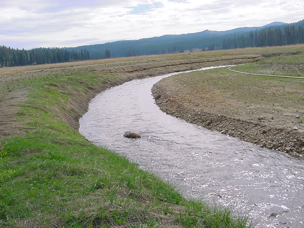
The river restoration design was based on a 1936 photograph of the meadow showing river meandering patterns, amplitudes, and frequency. The new meander pattern was designed as a complex and irregular succession of bends intended to reconnect historic channel sections and lengthen the stream channel. Cross-sectional shapes were designed using estimated characteristic stream flows, natural channel shapes, fish habitat criteria, and hydraulic geometry relationships. Channel cross-sectional shapes differ depending on the type of reach - straight, transition, or bend. Rock sills were used as grade control structures to raise ground and surface water elevations, reduce erosional forces, and provide soil moisture conditions suitable for native riparian vegetation. For each sill, approximately 20 boulders ranging from 36 inches (91 cm) in diameter were placed across the channel in an arc shape, with the apex of the arc positioned on the upstream side. Several boulders were anchored into each streambank.
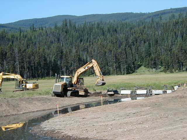
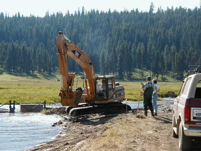
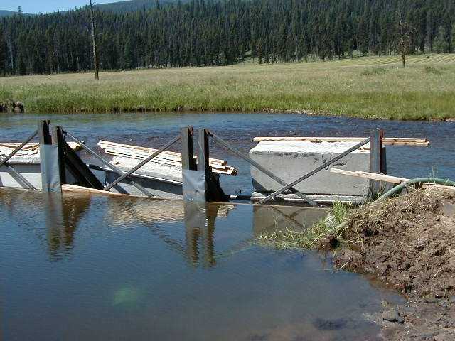
Once reconstruction was completed, water was diverted into the new channel in a sequential manner by using temporary diversion structures. The diversion structures--water bladders and concrete highway barriers--were placed across the width of the existing channel to alter the stream course and divert live water into the new channel. Diverting water into the new channel section, dewatering the former channel section, and transferring fish from the former channel took place over several days. The following procedure was used in Phases I and II:
♦ A track excavator positions the water bladders or concrete highway barriers across the width of the upstream end of the channel section to be abandoned, slowly diverting water flow into new channel and blocking flow from former channel area.
♦ Geotextile sediment-control fabric is placed on upstream side of the diversion structures.
♦ The remaining water is allowed to freely flow out the downstream end of the channel to be abandoned; large fish leave the channel at this time.
♦ Residual water is pumped from the former channel onto the adjacent floodplain using a tractor-mounted pump equipped with fish screen on the intake hose.
♦ As the former channel was dewatered, a fisheries consultant or Idaho Department of Fish and Game (IDFG) staff supervised the electrofishing procedure to safely transfer remaining fish from the former channel to the new channel. Harm to fish was reduced by using the minimum required pulse rate and width and minimizing handling time.
♦ The downstream diversion structure is installed as fish are being transferred, preventing fish migration back into former channel.
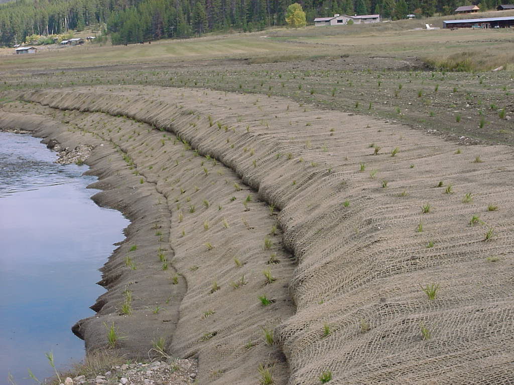
Before temporary diversion structures were removed, reinforced banks were installed at the upstream end of the former channel, and the entire former channel was backfilled with soil and gravel excavated from new or historic channel sections. Reinforced banks consist of layers of rocks and logs with soil and gravel fill and are designed to prevent recapture of the old channel alignment. These structures extend the entire width of the former channel and are anchored into each bank. The reinforced bank was completely buried with backfill material, except near the water's edge. Where log ends meet the water's edge, localized lateral scour pools, beneficial as fish habitat, are expected to develop.
In order to ensure water quality, this engineering component of the restoration was designed in accordance with the following best management practices:
- All in-channel work, below the ordinary high water mark, was limited to a six week period--July 1st - August 15th--in order to minimize construction-related impacts to spawning, rearing, and migration of anadromous and resident fish.
- Excavation took place in dry channels, whenever feasible, by maintaining a soil plug between excavation activities and the live stream channel. Soil plugs were kept at the up- and downstream boundaries until new stream reaches were ready to be connected with the live channel.
- Turbid water was pumped through vegetated historic channels or wetland swales whenever feasible in order to filter fines before water traveled back to the live stream channel. Pumps were equipped with fish screens on intake hoses. Constructed pools in the new channel bends and enhanced pool areas in the historic bends were also used to settle sands.
- Stream channel crossings with heavy equipment were minimized, and when crossings occurred, they were located in shallow, straight reaches with gravel/cobble substrate and no previous history of redds.
- Equipment traffic during wet weather or within wet zones was minimized as an erosion control measure.
- Excavated material was stockpiled at a distance from the live stream channel and above the ordinary high water mark to reduce the risk of high-water inundation. All excavated material not used as backfill in the former channel was placed in upland areas.
Once the channel modifications were successfully completed, active revegetation of the site began. Species comprising the once prevalent native plant communities were hypothesized using on-site and adjacent land surveys, current published literature, historical data and photographs, and local accounts of historical conditions. Nearly 115,000 native riparian and wetland plants, including a variety of woody shrubs (willows, red osier dogwoods, serviceberry, thinleaf alder) and herbaceous seedlings (sedges, rushes, bulrushes), were planted throughout Phases I-IV. Due to low rainfall, typical during the summer months in the lower meadow, irrigation was supplied, where necessary, to ensure quick establishment and improve survival rates of newly sown seed and planted seedlings.
In general, planting locations were selected according to the hydrologic requirements and big game palatability of a particular species. For example, species requiring the highest amount of soil moisture, such as Drummond willow and sandbar willow, were placed closest to the water's edge. Drummond willow and red-osier dogwood, highly palatable to big game animals, were planted into the outside cut banks where access is difficult. Less palatable species, such as thinleaf alder, were used in the more game-accessible straight reaches.
Willow species were planted as dormant pole cuttings during the late spring and summer. Other woody shrubs were planted as seedling plugs. Since native sources were unavailable on-site, the willow pole cuttings were collected as close to the project site as possible. Seed sources for alder, dogwood, aspen, honeysuckle, serviceberry, and hawthorn were found on the project site, as well as up- and downstream. Willow pole cuttings were collected, prepared, and cooler-stored during February and March prior to each field season. Pole cuttings were removed from the cooler and soaked in water for three days at ambient outside temperatures to initiate bud and root growth just prior to spring/summer planting. Seeds of thinleaf alder, red-osier dogwood, serviceberry, and other native woody species were collected in the summer/fall, cleaned and prepared for storage during the winter, and then planted in a commercial greenhouse in late winter and early spring (February through May). Seedlings could then be planted in the fall or the following spring. Seedlings held over until the following spring were moved into a cooler during peak dormancy (January) and stored until ready to plant.
Pacific and Geyer willow poles, ranging 5 to 10 feet (1.5 to 3 meters) in length, were placed within 20 feet (6.1 meters) of the water's edge on top of the bank or terraces. The terraces of outside bends were planted with a higher density planting (approximately 1.8 to 3 meters on center) compared to straight reaches or inside bends. A tree planting auger was used to drill 4 inch (10 cm) diameter holes as deep as possible to ensure the cuttings reach the mid-summer water table. An auger-resistant layer of river rock/gravel occurs at varying depths throughout the meadow. Holes drilled less than 32 inches (81 cm) deep, due to this impenetrable gravel layer, were abandoned and refilled. A single pole was placed in each hole and, if possible, pressed further into the ground. The holes were then backfilled with existing soil to achieve good soil-to-stem contact.
Drummond and sandbar willow poles, ranging from 4 to 8 feet (1.2 to 2.4 meters) in length, were placed at or near the water's edge. Depending on soil conditions, both Drummond and sandbar willow can either be inserted by hand or placed in a drilled hole. Drummond willow poles were pushed into the soil to reach the mid-summer water table, usually at a 45- degree angle to the vertical bank along outside bends. Drummond willow poles were planted in high densities, often exceeding 1 foot (30 cm) on center, to accelerate the development of stable streambanks, shade and cover, and reduced water temperatures. Sandbar willow poles were pushed into the soil at or below the waterline on the inside bend point bars. In areas where soil conditions precluded hand placement, a hole was drilled to a 2-foot (61-cm) depth, the pole cutting was placed, and the hole was then backfilled to achieve good soil-to-stem contact. Sandbar willow poles were planted in point bar areas to facilitate long-term sediment deposition and subsequent decrease in channel width.
Thinleaf alder seedlings were planted along straight reaches and red-osier dogwood were interspersed amongst the Drummond willow along the outside bend cut banks. Serviceberry seedlings were planted on the top of banks or terraces. Woody seedlings were planted using an auger with a 1.5-inch (3.8-cm) diameter earth bit or hand dibble. The seedling was placed into the hole and then backfilled, using care not to create airspace along the seedling plug and soil interface.
Seeds from herbaceous plant species--dagger-leaf rush, Coville's rush, Colorado rush, small-fruited bulrush, small-winged sedge, lens sedge, and beaked sedge--were collected on the project site in August and September. Seedlings were grown in a commercial greenhouse in 10 cubic inch (164 cubic cm) containers the following spring and early summer and delivered to the meadow for planting in August and September.
Herbaceous plants were also placed according to their specific hydrologic and other known habitat requirements. Dagger-leaf rush, Coville's rush, and small-fruited bulrush were planted at or near the water's edge. Colorado rush and small-winged sedge were planted in dryer sites on top of the banks or terraces. Lens and beaked sedge were planted into the slumped areas of cut banks and in off-channel water-holding depressions.
The majority of seedlings were planted with a 1.5-inch (3.8-cm) diameter, gas-powered auger/drill; a small percentage was planted with a hand dibble. The herbaceous seedlings were planted in varying densities. The design specifications set the spacing of herbaceous seedlings on approximately 4-foot (1.2-meter) centers, interspersed amongst the woody shrub species. In areas disturbed by construction and more susceptible to erosional forces, such as exposed vertical banks, herbaceous plant densities were increased.
Finally, an erosion-control seed mix was sown in newly exposed soil disturbed by construction activities, such as reinforced banks, former channel areas, and access roads. Prior to seeding, a finish-sized D4 bulldozer performed the final grading in construction areas and obliterated temporary access roads. A four or six-wheeled ATV with harrow attachment followed the final grading to prepare a smooth seed bed. Using a spreader mounted on the ATV, the erosion control seed mix was broadcast over the disturbed areas. The seed mixture was comprised of the following five species and percentages: Sheep fescue (Festuca ovina) 30%; Bromar mountain brome (Bromus carinatus) 30%; Sherman big bluegrass (Poa sandbergii) 15%; Canada Bluegrass (Poa compressa) 15%; and White dutch clover (Trifolium repens) 10%. All of these species were mixed with ReGreen, a sterile wheatgrass/wheat hybrid that establishes quickly, providing first year erosion control, before dying out and allowing the native species to establish.
The planted seed was subjected to a second harrowing to ensure good contact with the soil surface. A coconut fiber (coir) erosion control fabric was placed and stapled to the leading 50- foot (15-meter) edge of the reinforced bank areas (upstream ends of former channel). These areas were then re-seeded with the erosion control seed mixture. A general purpose fertilizer (16-16-16) was applied with a hand spreader over all planted areas.
Eleven wildlife exclosures were installed to aid the study of ungulate browsing impacts on plant survival and provide important information for developing adaptive management strategies.
Ecological Outcomes Achieved
Eliminate existing threats to the ecosystem:
Phase I (1996) and Phase II (1997) engineering accomplishments included reconnecting two historic channel meanders (Goose Island Bend and Historic S-Curve Loops), constructing two new meanders (Big Bend and Giant Bend), and accentuating three existing outside bends(Two-Sill Bend, Hopeful Bend, and Ninety- Degree Bend). Due to these changes in channel alignment, the channel length on the entire RRWMA increased by 3,060 feet (933 meters), channel gradient decreased by 25 percent, and sinuosity increased from 1.7 to 2.3. Channel cross-sectional shapes and point bars were modified or created to maintain deep pool habitat during low flows, convey average annual flows within the channel, and dissipate flood flows onto the floodplain. Six rock grade control structures were installed to raise low flow surface water and groundwater elevations. A pond/wetland area, approximately 200 feet by 125 feet (61 meters by 38 meters) was constructed in Phase II to provide additional shallow and open water habitat for waterfowl and other wetland dependent species. Several log habitat structures were keyed into the outside streambanks of Big Bend and Hopeful Barb Bend. As the channel stabilizes with time, reduced stream bank and bed erosion rates and improved water quality are expected. Increases in both surface water and groundwater elevations will enhance soil moisture conditions and reconnect tributary mouths, backwater channels, and other off-channel rearing habitat to the main channel.
The following is a summary of findings from a series of post-restoration monitoring activities:
- Sinuosity and Slope:
Restoration activities increased channel length by 1.54 km or 60%, resulting in a 60% increase in sinuosity from 1.7 in 1994 to 2.7 in 2000. Slope decreased by 40% from 0.0025 in 1994 to 0.0015 in 2000. Channel alignment, sinuosity, and slope are now similar to 1936 historic conditions.
- Velocity and Water Surface Elevations (WSE):
Compared to pre-restoration conditions (1994), median bankfull water velocity was significantly slower immediately following restoration (2000), but not 3 years later in 2003. No significant changes occurred in median low-flow velocity. For both bankfull and low flow, median distances between the water surface and tops of high and low banks decreased significantly when comparing pre-restoration (1994) to both immediately (2000) and 3 years post-restoration (2003). Significantly shorter distances were also found in 2003 compared to 2000.
- Groundwater Depth:
Mean groundwater depth for the growing season ranged from 0.75 m during 1998 to 1.08 m during 2000. After adjusting for month of observation and linear influence of discharge, no significant temporal trend in depth to groundwater was detected.
- Hydroperiod and Floodplain Inundation:
Modeling simulations illustrated an average increase in post-restoration hydroperiod by more than 25 days of 200%. Based on modeling at bankfull discharge, areal extent of post-restoration floodplain inundation increased by nearly 150% and volume of water stored on the floodplain increased by nearly 200%.
- Riparian Transect Composition:
Mean native plant cover in the phase I riparian transects increased significantly from 32% in 1997 to 57% in 2001, reaching 65% in 2003. Mean native cover in phase II decreased from 74 to 52% between 1998 and 2001 and then exhibited a nonsignificant increase to 63% in 2003. Phases III and IV experienced decreases in native cover between 2001 and 2003, from 69 to 51% and from 83 to 77%, respectively.
- Greenline Transect Composition:
Mean native greenline plant cover in phase I decreased from 49 to 43% between 1997 and 2001 and then exhibited a nonsignificant increase to 64% in 2003. Native cover in phase II experienced consecutive decreases from 73 to 53 to 49% between 1998, 2001, and 2003. The native cover of phase IV decreased from 88 to 68% between 2001 and 2003, whereas that of phase III remained unchanged at 58%.
- Fish Habitat Diversity:
The total number of habitat units increased by 52%, from 48 to 73, between 1994 and 2001. The count remained at 73 in 2002 and then increased to 102 in 2003. Although the number of habitat types fluctuated during the four survey years, by 2003, the number of pools increased by 300%, riffles increased by 24%, and runs/glides increased significantly by nearly 150% compared to pre-restoration (1994) conditions. Area occupied by each habitat type also fluctuated between survey years. However, in each post-restoration survey, deepwater habitats (pool + run/glide) occupied between 36 and 54% more area compared to pre-restoration, whereas shallow habitat (riffle) occupied 51-78% less. The overall increase in area and percent composition of deepwater habitat was not statistically significant.
- Salmonid Density:
Salmonid denisities fluctuated among the five survey years, ranging from 7.1 fish/100 m2 in 2003 to 27.8 fish/100 m2 in 2001. Although salmonid densities were greater than non-salmonids each year, no significant increasing trend in salmonid density or percent composition was detected in the restored reach. When considered separately, nonrestored (control) transects also exhibited no significant increases in salmonid density. When drainage-level data were combined, a significant increasing trend in salmonid density was detected. But no significant differences were found in linear trends of salmonid densities between locations, including comparisons to the restored reach.
- Redd Counts:
Annual Chinook redd density in the restored site also fluctuated, ranging from 0.0/km in 1994 to 17.7/km in 1997. No significant increase in redd density was detected. Similar annual variability occurred in non-restored (control) reaches of the drainage, and no significant differences were detected when compared to the restored site.
- Bird Populations and Diversity:
Although fluctuations occurred between 1996 and 2003, bird numbers increased significantly from 52 in 1996 (pre-restoration) to 91 in 2003 (3 years post-restoration), with the highest value (128) reported in 2001. Spearman's correlation coefficient detected a significant positive relationship between the number of bird species and years. Shannon's index of species diversity increased significantly for the same time period.
Factors limiting recovery of the ecosystem:
From 2002 through 2004, additional plantings were installed and a variety of plant protection strategies were implemented in response to monitoring results that indicated woody riparian plantings were exhibiting slow growth rates and reduced vigor and performing below expectations. This poor performance is attributed to ungulate browsing and rodent damage, vegetative competition, local soil moisture conditions, and the short growing season. Plant protection and growth enhancement strategies included browse control, weed control, tree tubes, fencing, and fertilizer applications.
Although aquatic habitat structure has improved, no significant positive trends with time in salmonid densities or chinook redd densities were detected in the project reach. Off-site conditions beyond the project's control and natural and human-induced fluctuations in both anadromous and resident fish populations affect the number of adult spawners in any given year and complicate analyses. Three years post-restoration is also early in the recovery process relative to expectations for positive changes in fish populations and chinook redd densities.
Bird numbers and species are increasing on the project site while overall terrestrial wildlife habitat has yet to exhibit improvements. Summer water temperatures are increasing. The native riparian shrubs, actively planted throughout the project site, continue to exhibit slow growth rates and reduced vigor, providing only a small percentage of cover in the riparian and greenline plant composition transects. Thus, a shading effect is currently unavailable to help reduce water temperatures, and in turn, to improve the thermal conditions of aquatic habitat. Until a woody riparian corridor, capable of intercepting solar radiation, is sufficiently established on both the restoration site and upstream, overall water temperature decreases, additional significant improvements to aquatic habitat, and significant increases in terrestrial wildlife habitat value appear unlikely.
Socio-Economic & Community Outcomes Achieved
Economic vitality and local livelihoods:
In 1997, the project team identified a number of education and public outreach activities having the potential to disseminate knowledge and experiences gained from the Lower Red River Meadow Restoration Project. Through these activities and in coordination with IDFG, the project teams hopes to encourage the use of the RRWMA and the restoration project for indoor and outdoor classroom activities. In addition, public outreach activities are necessary to promote the use of the project area as a model or demonstration site for similar projects in the region.
Key Lessons Learned
Although the full recovery of the site is expected to take several decades, the physical features of the channel are meeting or evolving toward the performance criteria, and are thus moving in the direction of expected habitat improvements. However, until a woody riparian corridor, capable of intercepting solar radiation, is sufficiently established on both the restoration site and upstream, overall water temperature decreases, streambank stabilization, additional significant improvements to aquatic habitat, and significant increases in terrestrial wildlife habitat value appear unlikely. The establishment of healthy riparian vegetation will depend on a continued commitment to monitor the hydrologic changes, evaluate the recently implemented vegetation protection strategies, and maintain and expand the use of those strategies that prove most effective.
Long-Term Management
A mature and dense woody riparian corridor is key to the overall success of this restoration project. Significant recovery of the riparian corridor, however, will depend on the following:
– Additional tree tubes, weed control mats, and fencing.
– Ongoing maintenance of plant protection structures.
– Replanting/fencing in critical streambank areas, concentrating on the west and south streambanks where dense, woody shrubs and trees can be most effective intercepting the solar radiation of the warm, afternoon sun.
– Routine browse control, fertilizer, and irrigation, as necessary, until plants are well-established and self-sustaining.
– Expanding the riparian corridor plantings to the upstream property.
– Experimentation with other strategies such as clump plantings of mature willows.
– Commitment to evaluate the success of the vegetation protection strategies and to maintain and expand the use of those strategies that prove most effective.
– Continuation of the effectiveness monitoring and an adaptive management program to ensure the ecosystem maintains its path to recovery by confirming habitat improvements, isolating restoration effects for those features slower to respond, and identifying short-term maintenance needs.
Sources and Amounts of Funding
The Lower Red River Meadow Restoration Project (LRRMRP) began in 1993 with the collaborative purchase of the Little Ponderosa Ranch, one of the four properties in the lower meadow. Funding collaborators included the Bonneville Power Administration (BPA), Idaho Department of Fish and Game (IDFG), Rocky Mountain Elk Foundation, Trout Unlimited, and National Fish and Wildlife Foundation. This 314-acre parcel was then deeded over to IDFG in an Interagency Memorandum of Agreement (BPA and IDFG, 1994) in order to facilitate management of habitat restoration and fish and wildlife benefits as the Red River Wildlife Management Area (RRWMA).
The actual restoration work is part of the Northwest Power and Conservation Council’s Columbia Basin Fish and Wildlife Program (FWP) (1994, 2000), and is funded by the Bonneville Power Administration (BPA).
Other Resources
Red River Meadow Restoration Project
http://www.redriver.uidaho.edu/default.aspx?pid=51654
Klein, L. R., S. R. Clayton, J. R. Alldredge, and P. Goodwin. 2007. Long-term monitoring and evaluation of the Lower Red River Meadow Restoration Project, Idaho, U.S.A. Restoration Ecology 15:223-239.