Overview
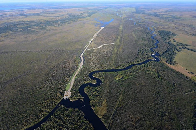
Once completed, the Kissimmee River Restoration will be the largest river restoration project in the history of the world. All told, the project will restore over 40 square miles of river/floodplain ecosystem, including 43 miles of meandering river channel and 27,000 acres of wetlands. Jointly managed by the South Florida Water Management District (SFWMD) and the U.S. Army Corps of Engineers (USACE), the project encompasses two primary components aimed at restoring natural hydroperiods and inundation patterns to the river and its adjacent floodplain: backfilling the C-38 canal (the channelized river’s main drainage) and changing water level management practices in the Kissimmee Chain of Lakes to maintain natural flow. The first phase of backfilling was completed in 2001 along approximately 12 km of C-38, and the results of post-construction monitoring surveys have been promising. While it is still too early to perform an accurate assessment of the impact on plant, fish, and herpetofaunal communities, initial observations following the restoration of flow to the channel suggest improvements in water quality (especially levels of dissolved oxygen); re-colonization by invertebrates and benthic species typical of flowing-water habitats (instead of those characteristic of lakes and other stationary bodies of water); and increasing densities of waterfowl and wading birds in the adjacent floodplain. Backfilling and construction activities will continue in the Kissimmee watershed until 2012, at which time an ambitious long-term management plan will be put into effect in hopes of preserving the dynamics of the river and perpetuating the ecosystem improvements that are realized.
Quick Facts
Project Location:
Kissimmee River, Florida, USA, 27.2706488, -80.99251190000001
Geographic Region:
North America
Country or Territory:
United States of America
Biome:
Freshwater
Ecosystem:
Freshwater Rivers & Streams, Freshwater Wetlands
Area being restored:
104 km2
Project Lead:
South Florida Water Management District (SFWMD) and the U.S. Army Corps of Engineers (USACE)
Organization Type:
Governmental Body
Location
Project Stage:
Implementation
Start Date:
1992-08-28
End Date:
2012-08-28
Primary Causes of Degradation
Urbanization, Transportation & IndustryDegradation Description
Two major hurricanes in the late 1940s led to mass flooding and extensive property damage throughout the Upper Basin, prompting the State of Florida to petition the federal government to prepare a flood control plan for Central and South Florida. In 1948, the U.S. Congress authorized the USACE to initiate construction of the Central and Southern Florida (C&SF) Project for flood control and other purposes. The primary project goals were to relieve flooding and minimize flood damages within the Kissimmee watershed and to improve navigational opportunities originally provided in the Congressional Act of 1902. Between 1962 and 1971, the meandering Kissimmee River was channelized and transformed into a 56-mi (90 km) long by 30-ft (9 m) deep canal that varied between 90 and 300 ft (27 and 91 m) in width, and was regulated by a series of five water control structures (USACE, 1991). The areas between water control structures, termed pools, function similarly to reservoirs and are named for the control structure at their southern terminus. Upper Basin project features were constructed between 1964 and 1970 and included dredging of canals between lakes and installation of water control structures to regulate lake levels and outflow (USACE, 1991).
Although the C&SF Project was extremely successful at achieving its flood control objective, it dramatically altered hydrologic conditions throughout the Kissimmee watershed (Obeysekera and Loftin, 1990). Water levels in the Kissimmee Chain of Lakes (KCOL) are now controlled by nine structures that regulate the amount and timing of discharges between lakes and to the Kissimmee River. Under regulation, the range of fluctuation has been reduced from 2 to 10 ft (0.6 to 3.0 m) to about 2 to 4 ft (0.6 to 1.2 m) annually (Obeysekera and Loftin, 1990). The historical, pre-regulated pattern of seasonal fluctuations provided periods of flooding and drying that played a critical role in maintaining the ecosystem’s health and that supported biological communities adapted to and dependent upon these fluctuations (Perin et al., 1982). Reducing the range of fluctuations has eliminated this natural cycle and promoted growth of dense vegetation that has resulted in the accumulation of organic material in littoral zones of these lakes (USACE, 1996). Smaller fluctuations also have allowed agricultural, residential, and commercial land uses to encroach upon historic flood zones surrounding the lakes, resulting in significant loss of wildlife habitat and higher nutrient inputs to the lakes (USACE, 1996).
Within the Kissimmee River valley, the physical effects of channelization, including alteration of the system’s hydrologic characteristics, drastically reduced the extent of floodplain wetlands and severely degraded fish and wildlife resources of the basin (USACE, 1991). Approximately 21,000 ac (8,500 ha) of floodplain wetlands were drained, covered with spoil material, or converted into canal (USACE, 1991). No-flow regimes in remnant channels encouraged extensive growth of floating vegetation, which impeded navigation (Toth, 1990a). Senescence and death of encroaching vegetation covered the shifting sand substrate with large amounts of organic matter, greatly increasing the biological oxygen demand of the system (Toth, 1990a). By the late 1970s, floodplain use by wintering waterfowl had decreased by greater than 90 percent compared to pre-channelization levels (Perin et al., 1982). Diverse and abundant wading bird populations declined and were largely replaced by the cattle egret (Bubulcus ibis), a species generally associated with upland, terrestrial habitats (Perin et al., 1982). The highly recognized largemouth bass (Micropterus salmoides) fishery was decimated, while fish species tolerant of low dissolved oxygen and reduced water quality, such as Florida gar (Lepisosteus platyrhincus), increased (Perin et al., 1982). Aquatic invertebrate taxa of the channelized system were typical of those found in lakes and reservoirs rather than riverine systems (Harris et al., 1995). Stabilized water levels greatly reduced river-floodplain interactions, disrupting critical food web linkages dependent on seasonal flooding and protracted floodplain recession rates (Harris et al., 1995).
Reference Ecosystem Description
Prior to channelization, the dominant floodplain plant communities included: broadleaf marsh (dominated by Sagittaria lancifolia and/or Pontederia cordata), wet prairie, willow (Salix caroliniana), and buttonbush (Cephalanthus occidentalis). These communities, especially wet prairies on the outer margins, supported large numbers and a high species richness of waterfowl (Audubon Society, 1936 – 1987; reviewed in Perrin et al., 1982). During eight years of winter surveys in the 1950s, a minimum of 12 and as many as 18 species of waterfowl were documented each year (USFWS, 1959). Bird species inhabiting the river and floodplain included four species that are currently listed as threatened or endangered by the U.S. Fish & Wildlife Service. Of these species, three are wetland specialists (wood stork, endangered; snail kite, endangered; bald eagle, threatened), while the fourth (Audubon’s crested caracara, threatened) utilizes a matrix of terrestrial and wetland habitats (Sykes et al., 1995; Morrison, 1996; Coulter et al., 1999; Buehler, 2000).
In 1957, the Florida Game and Freshwater Fish Commission (FGFWFC) collected 922 individual fish representing 24 species, and 11 families in Kissimmee River. Fish collected included both large (adults > 80 mm SL) and small-bodied individuals. The assemblage was dominated in abundance by small-bodied species (62.9 percent), especially golden shiner Notemigonus crysoleucas (39 percent). The remainder of the assemblage was comprised of largebodied centrarchids and esocids (35.7 percent) and a single catostomid (1.4 percent). Of the 329 centrarchids and esocids collected, 98 percent were juveniles or young of the year.
Project Goals
The goal of the restoration project is to restore ecological integrity to the river-floodplain ecosystem. This goal is defined as the “reestablishment of a river-floodplain ecosystem that is capable of supporting and maintaining a balanced, integrated, adaptive community of organisms having a species composition, diversity, and functional organization comparable to that of the natural habitat of the region.”
Monitoring
The project does not have a monitoring plan.
Description of Project Activities:
The purpose of the KRHRP is to provide the necessary water storage and regulations needed to approximate the historical flow characteristics for the Kissimmee River system. These purposes will be accomplished by increasing the water storage capacity of lakes Kissimmee, Hatchineha, Cypress, and Tiger by approximately 100,000 acre-feet (12,340 hectare-meters), and by increasing the conveyance capacity of the canals and structures to accommodate these increased storage volumes. Meeting these objectives involves (1) acquisition of approximately 20,800 ac (8,400 ha) of land bordering these lakes; (2) widening the C-36 canal between lakes Cypress and Hatchineha and the C-37 canal between lakes Hatchineha and Kissimmee; (3) adding two gates to the S-65 water control structure to increase the outlet capacity from Lake Kissimmee; and (4) modifying the stage regulation schedule for the S-65 structure.
The headwaters revitalization regulation schedule is zoned to provide varying discharges based on season and water level. Specifically, these modifications allow for a wider range of lake stage fluctuations, with maximum lake stages increasing from 52.5 ft (15.9 m) to 54.0 ft (16.4 m) National Geodetic Vertical Datum (NGVD). The new regulation schedule with increased maximum stage both provides for the reestablishment of pre-channelization seasonal outflow characteristics from Lake Kissimmee to the Lower Basin and benefits the lakes by expanding littoral zones and peripheral wetlands by approximately 14,000 ac (5,700 ha) (USACE, 1996). Additionally, the increase in the range of lake stage fluctuation is expected to improve the overall quality and productivity of littoral and wetland habitats.
To date, the C-36 and S-65 modifications are complete. The majority of lands that will be inundated as a result of increased stage on lakes Kissimmee, Hatchineha, Cypress, and Tiger have been acquired. The widening of C-37 is expected to be completed in 2006. The headwaters revitalization operation schedule will be implemented upon completion of the C-37 modifications.
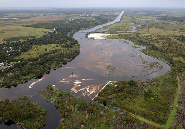
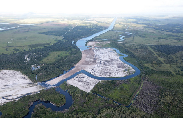
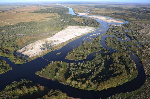
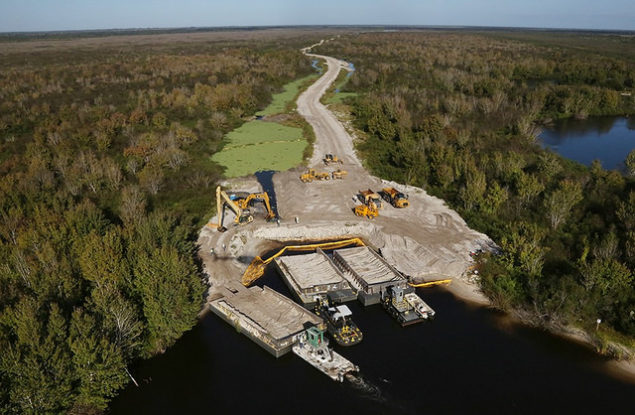
The river restoration component requires the acquisition of approximately 68,300 ac (27,640 ha) of land in the Lower Basin and involves a plan to (1) backfill an approximately 22 mi (35 km) section of C-38 from the lower end of Pool D to the middle of Pool B; (2) reconnect remnant river channels by recarving sections of river channel destroyed during C-38 construction; (3) remove the S-65B and S-65C water control structures and tieback levees; and (4) evaluate restoration success through a comprehensive ecological monitoring program. Backfilling of C-38 and recarving of river channels will be implemented in a series of construction phases to be completed in 2012; evaluation of restoration success will continue through 2017. Ultimately, the project will result in restoration of approximately 104 km2 of river-floodplain ecosystem, including 70 km of continuous river channel.
Ecological Outcomes Achieved
Eliminate existing threats to the ecosystem:
Phase I construction of the KRRP was completed in February 2001. Approximately 7.5 mi (12 km) of flood control canal C-38 was filled in Pool C and the southern portion of Pool B. Nearly 1.3 mi (2 km) of river channel was recarved and water control structure S-65B was demolished. These efforts reconnected 15 mi (24 km) of continuous river channel and allow for intermittent inundation of approximately 12,000 ac (4,900 ha) ha of restored floodplain.
Phases II and III, scheduled for completion in 2012, will fill the C-38 in Pool D. Numerous smaller ditches and works in the floodplain must be leveled or removed, some structures must be modified, some levees rebuilt, and the Pool C structure will be removed. Highway 98 and its bridge in the floodplain were raised in 2003 to allow the braided river to pass under it. The 4th and final Phase of backfilling will involve the C-38 canal in Pool B.
Initial responses to restoration activities in the Phase I area include: (1) maintenance of continuous flow for over three years in the reconnected river channel; (2) a reduction in the quantity and distribution of organic/marl deposition on the river channel bed; (3) an increase in the number of river bends with active formation of point sand bars; (4) an increase in the mean concentration of dissolved oxygen in the river channel from 1.2 to 3.3 milligrams per liter (mg/L) during the wet season and from 3.3 to 6.1 mg/L during the dry season; (5) a reduction in the mean width of littoral vegetation beds in reconnected river channels; (6) a shift in the structure of littoral plant communities from slight dominance by floating/mat forming species to heavy dominance by emergent species; (7) colonization by wetland vegetation of the filled C-38 and degraded spoil mounds; (8) colonization of mid-channel benthos by invertebrate species indicative of reestablished sand channel habitats; (9) dominance of woody snag invertebrate communities by passive filter-feeding insects, which require flowing water; (10) increased mean density of wading birds, including the endangered wood stork, from approximately 6 birds per square kilometer in the unrestored area to 20 to 24 birds per square kilometer in the restored area; (11) a decline in the abundance of the terrestrial cattle egret relative to aquatic wading birds on the floodplain; and (12) establishment of a new bald eagle nesting territory adjacent to the area of Phase I.
Following completion of Phase I, mean channel velocity at the three monitoring sites ranged from 0.113 m/s (0.371 ft/s) to 1.016 m/s (3.332 ft/s). Of the 88 measurements, only 33 (43 percent) were in the desired range from 0.244 to 0.549 m/s (0.8 to 1.8 ft/s). While this range of mean channel velocities in the restored river channel does not yet meet established criterion, it does show substantial improvement over the baseline period, when the remnant channels are assumed to have had a mean channel velocity of zero most of the time.
Mean thickness of organic/marl deposits ranged from 0 to 11 cm. The highest values occurred at two transects located in MacArthur Run. Upstream of these two transects, a side channel was created during a high flow event that diverts most of the flow back to C-38. Mean thickness averaged 4 cm, which was a 71-percent decrease from the baseline value and was lower than the reference condition. The percent of samples on a transect lacking organic/marl deposits ranged from 9 to 96 percent. The average value of 64 percent was an increase of greater than 2,000 percent over the baseline value of 3 percent. Thickness at the thalweg ranged from 0 to 34 cm and averaged 4 cm. This average value represents a decrease of 81 percent from the baseline value, and was less than the reference value of 9 cm. Despite the inclusion of two transects downstream of the flow diversion in MacArthur Run, all three metrics used to describe river bed deposits exceeded the response suggested by the reference values. This decrease in the amount and extent of coverage by organic/marl deposits on the river channel bed exceeded the response expected based on the reference condition. While this study shows a clear transition from river channel organic/marl deposits to sand, it did not distinguish between changes caused by erosion and those caused by in situ burial.
Point bar formation on meander bends was evaluated after nine months of continuous flow by reconnaissance from boat. In the area of Phase I, 63 meander bends were found with active point bar formation. This number is a substantial increase over the baseline period, where no evidence of active point bar formation on meander bends was found in aerial photography in the area of Phase I. However, the initial response value was not as high as the reference value of 80 meander bends with point bars that was determined from aerial photography of the same reach of the river collected at low water prior to channelization.
Within the channelized river, dissolved oxygen (DO) concentrations were frequently below 1 mg/L throughout the water column at all times of day. During 1996 - 1999, mean DO concentrations in remnant river runs in Pool A and C were 1.4 and 1.2 mg/L, respectively, during the wet season, and 3.1 and 3.3 mg/L, respectively, during the dry season. DO concentrations exceeded 2 mg/L for 22 percent of the baseline period, and 5 mg/L for 6 percent of this period.
Following completion of construction for Phase I of the restoration, mean daytime DO concentrations within the restored area were 3.3 mg/L during the wet season and 6.1 mg/L during the dry season. Post-construction DO concentrations in the control area (Pool A) were 1.1 and 4.5 mg/L during the wet and dry seasons, respectively. Mean daily water column DO concentrations were > 2 mg/L for 85 percent of the time. Dissolved oxygen concentrations within one meter of the channel substrate were > 1 mg/L over 50 percent of the time.
Initial responses to restored flow and habitat structure under the interim regulation schedule have been positive for mid-channel benthic and snag-dwelling invertebrate communities. Within three years of restoring continuous flow (June 2001 - June 2004), dominant benthic invertebrate taxa include native clams (Musculium/Pisidium/Sphaerium complex) and characteristic sanddwelling chironomids including Cryptochironomus spp., Tanytarsus spp. and Polypedilum spp. and numerous microcrustaceans. Other native bivalves, including Popenaias buckleyi and Anodonta spp., also have been collected in low numbers. Although never collected during the baseline period, empty shells of P. buckleyi and Anodonta spp. were observed along the river margin in Pool C. Corbicula fluminea, a nonnative clam, has greatly increased in numbers since reestablishing flow. Aquatic invertebrate community structure and functional group associations on large woody debris (LWD) also have shifted since reestablishing flow. Taxa characteristic of enriched lentic habitats and tolerant of low levels of dissolved oxygen have been replaced by taxa characteristic of free-flowing blackwater streams of the southeastern U. S. Preliminary analyses indicate dominance by passive filtering-collectors including Cheumatopsyche spp. (Trichopetra: Hydropsychidae), Cyrnellus spp. (Trichoptera: Polycentropodidae) and Rheotanytarsus spp. (Chironomidae). Recolonization by hydropsychid caddisflies and other passive filtering-collector taxa are consistent with restoration of biological integrity and recovery of the food base.
Use of river channels by waterbirds has changed following restoration. For example, prior to backfilling in Pool C, anhingas accounted for 6 percent of all river channel waterbird observations; following backfilling, anhingas averaged 15 percent of observations in 2001 - 2002, and 31 percent in 2003 - 2004. The total (as opposed to relative) number of anhingas using restored river channels also has increased. Laterally flattened fish such as sunfishes and bass are important food items for anhingas in Florida (Frederick and Siegel-Causey, 2000); increased use of restored river channels by anhingas may signal increases in the availability of centrarchid prey. During the baseline period, only two species of shorebird were recorded. However, following the first backfilling phase, an additional eight species returned to the river/floodplain, including: American avocet, common snipe, greater yellowlegs, killdeer, three species of sandpiper, semi-palmated plover, and breeding black-necked stilts.
As a group, wading birds (excluding cattle egrets) have exhibited a strong numerical response to newly restored habitats on the Pool C floodplain. While annual densities of wading birds in Pool A have never exceeded 6 birds/km2 during the years following Phase I backfilling, densities in restored areas have averaged 20 and 24 birds/km2 during 2002 and 2003, respectively. Monthly densities of wading birds in the restored area have been as high as 57 birds/km2 and have exceeded 20 birds/km2 in 10 out of 21 post-Phase I surveys. The white ibis, which likely was the most common Kissimmee River wading bird species prior to channelization (Audubon Society, 1936 - 1987), had the highest counts in 12 out of 21 post-Phase I surveys. The primarily terrestrial cattle egret, which flourished after the majority of floodplain wetlands were converted to cattle pastures in the channelized system, has declined relative to aquatic wading birds on the restored floodplain. This species outnumbered all other wading bird species combined during baseline surveys, but averaged only 24 and 14 percent of total wading bird counts in 2001 - 2002 and 2003 - 2004, respectively.
The American wigeon, northern pintail, northern shoveler, ring-necked duck, and fulvous whistling duck were not seen during baseline surveys, but have been present following restoration. Winter densities of ducks in the restored area were 9.5 ducks/km2 in 2001 - 2002, and 3.1 ducks/km2 in 2003 - 2004; duck densities in Pool A during these years were 2.9 ducks/km2 and 1.0 ducks/km2, respectively.
The restoration of natural hydroperiods and associated ecological integrity of the floodplain is necessary before plant, fish, or herpetofaunal assemblage responses can be evaluated. Therefore, these communities have not been included in monitoring surveys to date. However, anecdotal information indicates fish use of inundated floodplain habitats since completion of Phase I backfilling. Abandoned pit nests have been noted on restored portions of the floodplain and adults of large-bodied species including Florida gar, chain pickerel, and bluegill have been observed during periods of moderate to high inundation.
Factors limiting recovery of the ecosystem:
All project phases (i.e. I, II and III) are behind schedule due to land acquisition and modeling delays.
Socio-Economic & Community Outcomes Achieved
Key Lessons Learned
Successful completion of the KRRP, KRHRP, and KCOL LTMP has critical implications for other ecosystem restoration projects in South Florida. For example, the restoration project should increase phosphorus retention within the Kissimmee River system through restoration of floodplain wetlands, thus removing a portion of phosphorus loads that would otherwise reach Lake Okeechobee. Additionally, the KRRP is a prerequisite for successful completion of the Comprehensive Everglades Restoration Program (CERP). According to the future-without-plan condition under CERP, it is assumed that the KRRP is in place and functioning (USACE and SFWMD, 1999).
Long-Term Management
The Kissimmee Chain of Lakes Long-Term Management Plan (KCOL LTMP) was initiated in April 2003 through a South Florida Water Management District (SFWMD) Governing Board resolution (Resolution No. 2003-468). The purpose of this plan is to improve and sustain the ecosystem health of the regulated lakes in the KCOL, while minimizing adverse impacts to downstream ecosystems. The KCOL LTMP is intended to pick up where the KRHRP leaves off, as the KRHRP only includes lakes Kissimmee, Hatchineha, Cypress and Tiger, and does not address lake-level regulation in the 16 lakes north of Lake Cypress. Furthermore, KRHRP does not consider requirements for treatment of hydrilla (an invasive aquatic plant species) or lake habitat restoration and enhancement projects. The KCOL LTMP spans the entire watershed and will focus on how to regulate the KCOL and Kissimmee River in accordance with one another, while meeting flood control, water supply, aquatic plant management, and natural resource operations objectives for these systems and Lake Okeechobee. A coordinated, interagency project, the KCOL LTMP will contribute significantly to development of a watershed plan for the region by providing a scientifically based management strategy for the Kissimmee Chain of Lakes. It will be essential for addressing specific water quality needs that are not included in other watershed management programs already under implementation.
Sources and Amounts of Funding
578 million USD The cost of the project is being shared by the State of Florida and the Federal government. Most of the state’s fiscal responsibility arises within the context of land acquisition, and is met through funds provided by the Save Our Rivers and Preservation 2000 programs. The federal portion of the project cost will be provided through annual budgetary appropriations.
Other Resources
South Florida Water Management District Project Website
http://www.sfwmd.gov/org/erd/krr/