Overview
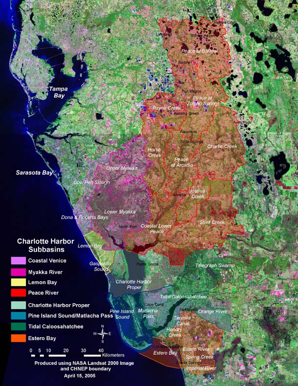
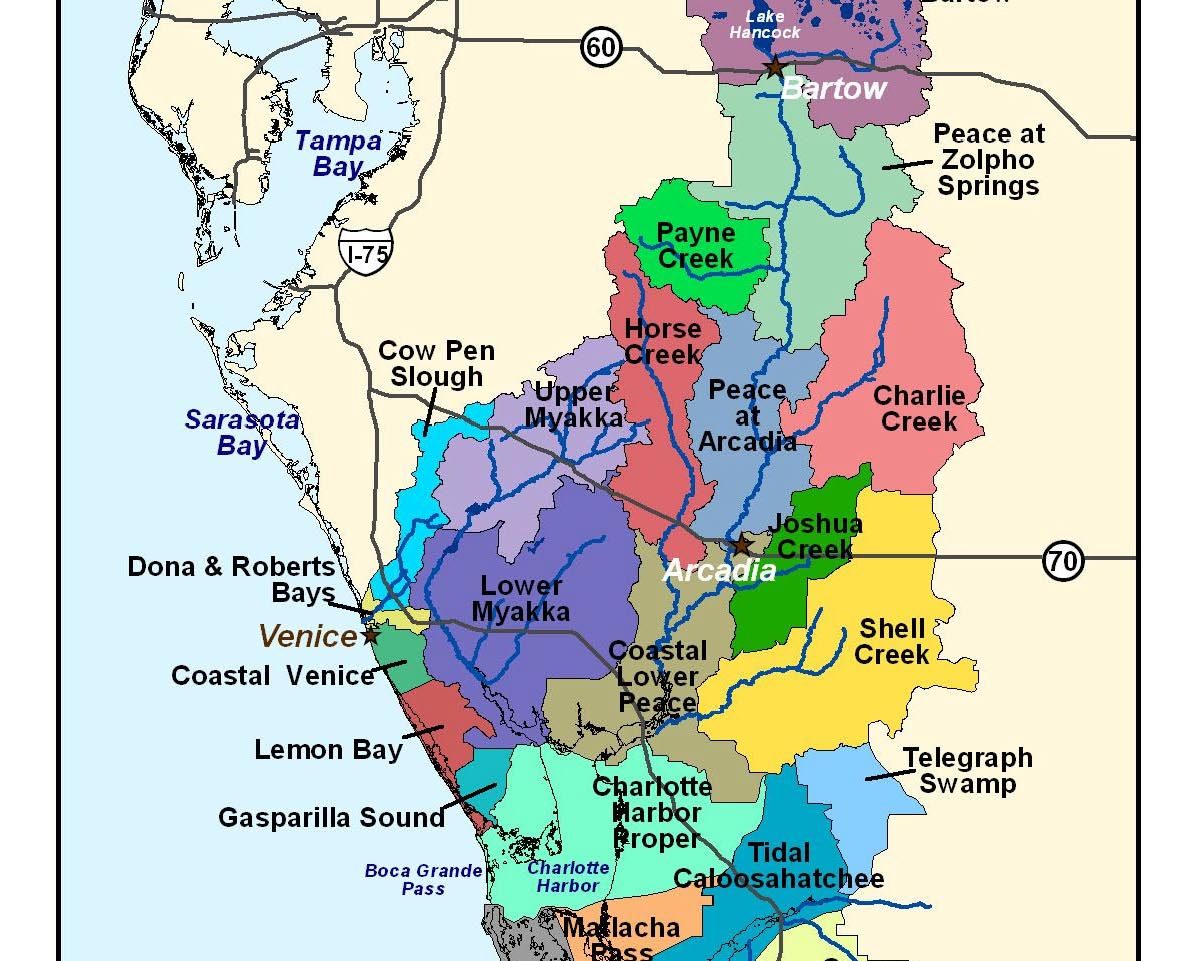
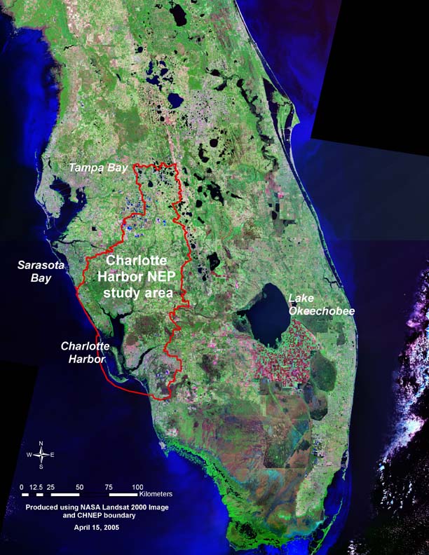
Charlotte Harbor is the second largest open water estuary in the state of Florida. Located on the west coast of Florida, Charlotte Harbor includes eight basins; 1) coastal Venice, 2) Lemon Bay, 3) Charlotte Harbor, 4) Gasparilla Sound, 5) Pine Island Sound, 6) Matlacha Pass, 7) San Carlos Bay, 8) Estero Bay, as well as the Myakka, Peace and the Calloosahatchee rivers. This covers an estimated 4,500 square miles (11,655 square kilometers). In the year 2000 the urban population in this area was reported to be nearing 1.5 million distributed across 16 cities. It is suggested that by 2010 this population is projected to reach an estimated 1.7 million. Consequentially, urban development will grow resulting in increased upstream water consumption furthering the intensive use of boats, cars, and roads threatening the health of coastal habitats. An economically viable estuarine system with respect to fishing, agriculture, mining, tourism, retirement and construction, the Charlotte Harbor and its watershed are considered vitally important assets to the Florida sun coast with a total income of $3.2 billion per annum.
Unique when compared to adjacent Florida estuarine systems, Charlotte Harbor’s system is mostly influenced by its large rivers. For instance, the watershed for the Peace River is 26 times larger than the estuary that it drains into (for every acre of water, 26 acres of land drains into the estuary). Additionally, physical features such as the Barrier islands protect the estuaries and the mainland from damaging storm waves and floods creating still habitat for mangroves, sea-grasses, fish and birds. The Charlotte Harbor estuary and its coastal waters serve as a home, feeding ground and/or nursery area for a number of resident, migrant, and commercial fish species throughout the Gulf of Mexico. Numbers of species throughout the study area include: 452 fish, 331 birds, 2,100 plants, 39 mammals, 67 reptiles, and 27 amphibians – some of which are federally endangered or threatened. As a result, the National Estuary Program (NEP) was established during the mid-1980’s.
In 1987 the National Estuary Program was established by amendments to the Clean Water Act to identify, restore and protect estuaries along the coasts of the United States. On July 6th, 1995 Charlotte Harbor Estuary became an “area of national significance” thus a candidate for the National Estuary Program. Once the Charlotte Harbor was established as a national program, a decision-making team was developed to identify and prioritize the main problems with the estuary.
Although problems found in the estuary and adjacent areas varied geographically in extent and severity, they were relatively uniform throughout the study area. As a result, fifteen quantifiable objectives and 48 priority strategies were developed to address these problems. What they came up with was a 20-year Comprehensive Conservation and Management Plan (CCMP) comprised of four committees; 1) The Policy Committee – to establish policy, 2) The Management Committee – oversees the operation of the program, 3) The Technical Advisory Committee (TAC) – guided technical decisions, and 4) Citizens Advisory Committee (CAC) – represents the interest of the public. Once the Management Plan was completed and accepted by the Management Conference in April of 2000, the State of Florida and the U.S. congress, action to restore and protect the estuarine system started to take place in June of 2001. One main objective within the management plan was to challenge local communities to address water quality, wildlife habitat loss, land use changes, and human-induced changes to river flows to protect uses of the estuary – emphasizing the bottom line that is, when the quality of natural resources diminishes, so does the economy.
Quick Facts
Project Location:
Charlotte Harbor, FL, USA, 26.9583937, -82.06703329999999
Geographic Region:
North America
Country or Territory:
United States of America
Biome:
Freshwater, Coastal/Marine
Ecosystem:
Estuaries, Marshes & Mangroves
Area being restored:
4.400 (11,396) Square mile (square kilometers)
Organization Type:
Governmental Body
Location
Project Stage:
Planning / Design
Start Date:
1996-06-06
End Date:
2007-06-06
Primary Causes of Degradation
Agriculture & Livestock, Mining & Resource Extraction, Urbanization, Transportation & IndustryDegradation Description
Land use changes, including large scale urbanization
The effect of boat traffic and dredging of the Intra-coastal Waterway
Effects on water quality of septic systems and storm-water runoff from developed areas
Project Goals
Hydrologic Alterations
1) Establish values for minimum seasonal flows for select rivers, and achieve those flows by 2020.
2) Identify, establish and maintain natural seasonal variation in freshwater flows by 2010, with respect to Caloosahatchee River, the upper Peace River, and upper Myakka river.
3) Restore, enhance and improve where practical historic boundaries and natural hydrology within the study area with special attention to Outstanding Florida Waters, Class I water-bodies and tributaries to Estero Bay by the year 2020.
4) For those area’s that have been affected by artificially created structures, these will be enhanced and improved upon to reflect their more natural hydrologic conditions by 2020. These structures include the Sanibel Causeway, the weir below Upper Myakka Lake, the crossing below Lower Myakka Lake, Down’s Dam on the Myakka River, the causeway between Lover’s Key State Recreation Area and Bonita Beach, the water control structure on the south end of Lake Hancock, the structure on Coral Creek and the Gator Slough canal collector system in Lee and Charlotte counties.
Water Quality Degradation
5) Identify those water bodies that do not meet designated water standards, and to develop a plan to have them meet those standards.
6) Develop Total Maximum Daily Loads (TMDLs), except for mercury, for high priority 303(d) listed water segments by 2004 and for all remaining 303(d) waters in the stuffy area by 2009.
7) Meet or exceed designated water quality standards throughout the study area by 2015.
8) Achieve water quality that will meet shellfish harvesting standards throughout the Class II waters of the study area by the year 2015.
9) Restore and maintain Lake Hancock to Class III water quality standards and improve the Trophic State Index (TSI) value for the water exiting the lake from “poor” to “good” by the year 2010.
Conservation
10) Meet or exceed designated water quality standards throughout the study area by 2015.
11) Identify water-bodies that should be designated as Outstanding Florida Waters and support the establishment of that designation during the year 2000.
Fish and Wildlife Habitat loss
12) Achieve a 25 percent increase from 1998 levels in conservation, preservation, and stewardship lands in the study area by the year 2018.
13) Increase the extent and improve the quality of habitats in the study area, including native submerged aquatic vegetation, intertidal un-vegetated habitats, mangroves, saltwater marsh habitats, freshwater wetland systems, oyster bars and upland communities.
14) Reduce propeller damage to sea-grass beds, identified from the 1992-1993 baseline data, within the study area by the year 2010. Reduce all severely scarred areas to light scarring and reduce 70 percent or more of the moderately scarred areas to light scarring.
15) Achieve controllable levels of invasive exotic plants as defined by the Florida Exotic Pest Plant Council by the year 2020 on conservation, preservation, stewardship and other public lands in the study area. Encourage and support the removal and management of invasive exotic plants on private lands.
Monitoring
The project does not have a monitoring plan.
Stakeholders
The stakeholders consist of a network of existing public and private organizations in addition to citizen volunteers. The contribution made by each organization and the roles each hold for the duration of the project is determined by: their mission, jurisdiction, legal authority, and budget. These organizations include: The County Governments of Charlotte County, DeSoto County, Hardee County, Highlands County, Lee County, Manatee County, Polk County and Sarasota County, and the Cities/Towns of Arcadia, Bowling Green, Bartow, Fort Meade, Cape Coral, Fort Myers Beach, Fort Myers, Zolfo Springs, Lakeland, North Port, Punta Gorda, Sanibel, Venice, Wauchula and Winter Haven. Also included are the following three regional planning organizations: Central Florida Regional Planning Council; Southwest Florida Regional Planning Council; and Tampa Bay Regional Planning Council. State agencies include: Board of Trustees of the Internal Improvement Trust Fund; The Florida Land and Water Adjudicatory Commission; Attorney General; Forestry Division of Agriculture; Education Commissioner and Department; Department of Community Affairs (DCA); The Florida Fish and Wildlife Conservation Commission; Department of Environmental Protection (DEP); Department of Health (DOH); Department of Transportation (DOT); Florida State Office of Trade and Tourism Development; and the South and Southwest Florida Water Management Districts. Federal Government organizations include: Environmental Protection Agency (EPA); Department of Agriculture (DOA); Department of Commerce (DOC); National Oceanic and Atmospheric Administration (NOAA); Department of Defense (DOD); Department of Housing and Urban Development (HUD); Department of Interior (DOI); US Geological Survey (USGS); US Fish and Wildlife Service (USFWS); Department of Transportation (DOT); and the Federal Emergency Management Agency (FEMA). And finally, some of the contributing private organizations include: Charlotte Harbor Environmental Confederation of Southwest Florida, Sanibel-Captiva Conservation Foundation, Lakes Action/Education Drive, and the Gasparilla Island Conservation and Improvement Association.
Ecological Outcomes Achieved
Factors limiting recovery of the ecosystem:
The large size of the study area creates challenges for managers and citizens alike. The watershed has both rural and urban characteristics, freshwater and marine ecosystems, tourism and agricultural based economies, and diverse local issues and priorities. Due to the diversity and size of the Charlotte Harbor watershed, it is often difficult to determine whether changes are caused by natural conditions or human impacts. When a basin undergoes rapid simultaneous changes such as the construction of canals, the expansion of urban development, and the intensification of agriculture, understanding what and how human activities are effecting water quality, hydrology, and habitat requires a great deal of monitoring and analysis over a long period of time.
Socio-Economic & Community Outcomes Achieved
Sources and Amounts of Funding
The Charlotte Harbor National Estuary Program (NEP USD