
Overview
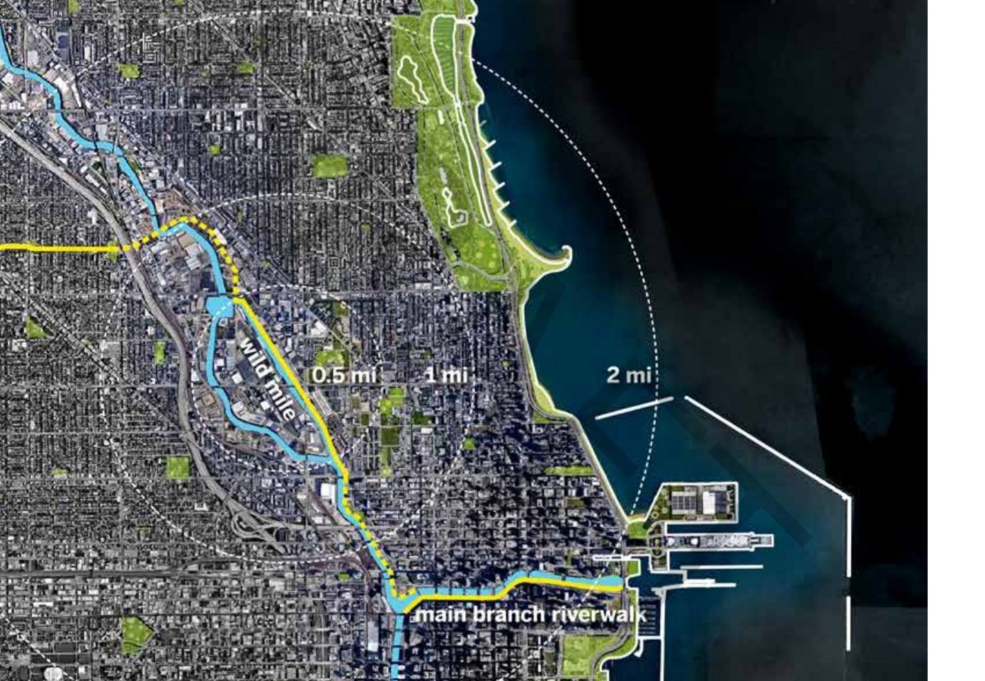
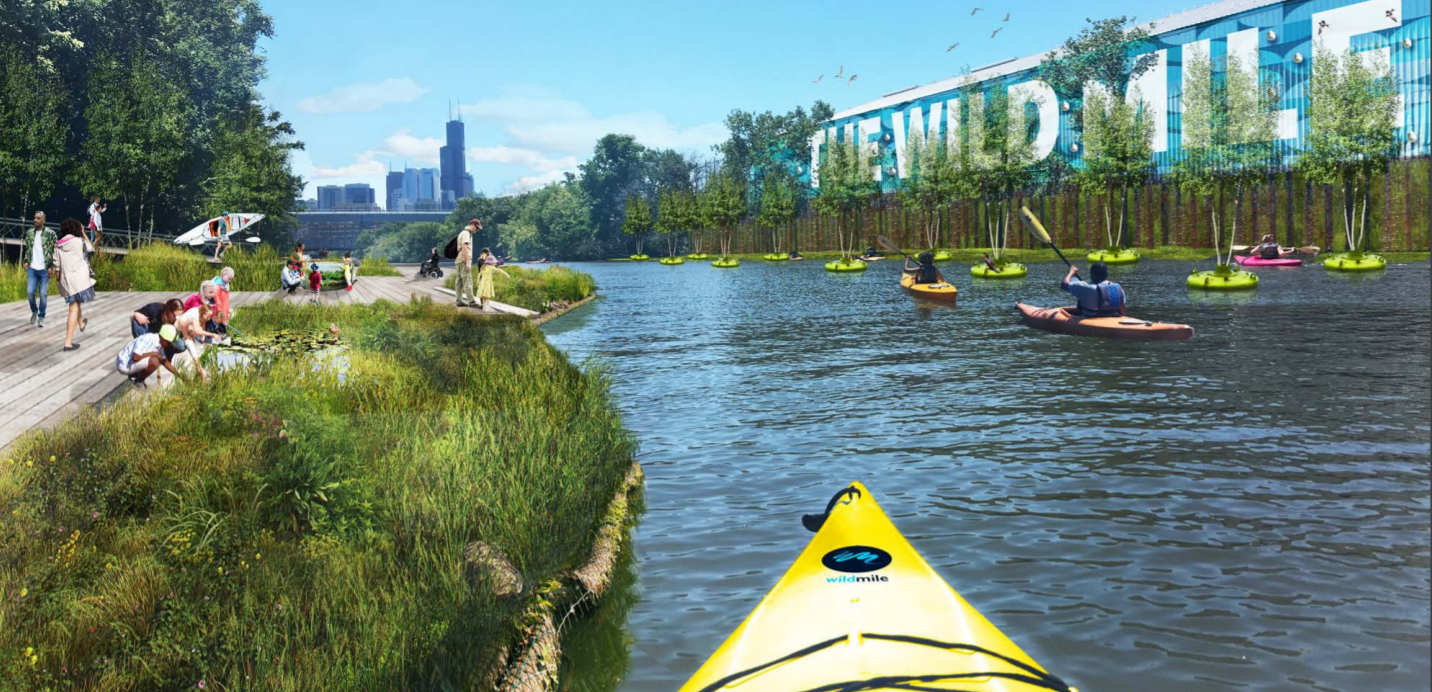
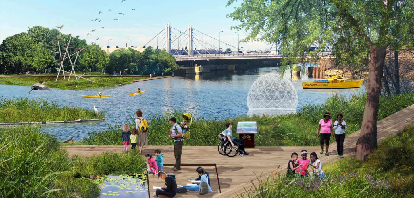
The Wild Mile is an on-going project to restore a mile-long stretch of the Chicago River on the urbanized North Branch Canal in Chicago, Illinois, USA. The Wild Mile will be a floating ecopark – an innovative solution to enhance ecology along concrete-channelized river in a heavily industrialized area. Unique from previous park installations focused on recreation, the main objective is to reintroduce riparian and emergent landscapes, encouraging wildlife to return to the city. The park will also function as a public park, open-air museum, community classroom and living laboratory. Architects, ecologists, and city planners came up with a modular plan to alter the current hard-edged banks of the river with floating native gardens and forests which promote pollinators and water quality, install nature-mimicking habitat structures for native wildlife that double as art installations, and develop water aeration mechanisms. They seek to lead the world in promoting innovation and experimentation to inspire holistic thinking around ecology and urbanism. The project is an interesting example of river restoration within the confines of an urban system. If successful, the lessons learned from installing the floating platforms can be expanded to other sections of the Chicago River and urban rivers worldwide.
Quick Facts
Project Location:
21022 Pullman Ave, Ford Heights, IL 60411, USA, 41.503121325549685, -87.58028123941801
Geographic Region:
North America
Country or Territory:
United States of America
Biome:
Freshwater
Ecosystem:
Freshwater Rivers & Streams
Area being restored:
1 mile
Project Lead:
Urban Rivers
Organization Type:
NGO / Nonprofit Organization
Project Partners:
City of Chicago Department of Planning and Development
Chicago Plan Commission
Skidmore, Owings & Merrill (Chicago-based architecture firm)
O-H Community Partners
Near North Unity Program
Omni Ecosystems
Tetra Tech
d’Escoto
Location
Project Stage:
Implementation
Start Date:
2014
End Date:
2020
Primary Causes of Degradation
Contamination (biological, chemical, physical or radiological), Dams & Hydrology, Urbanization, Transportation & IndustryDegradation Description
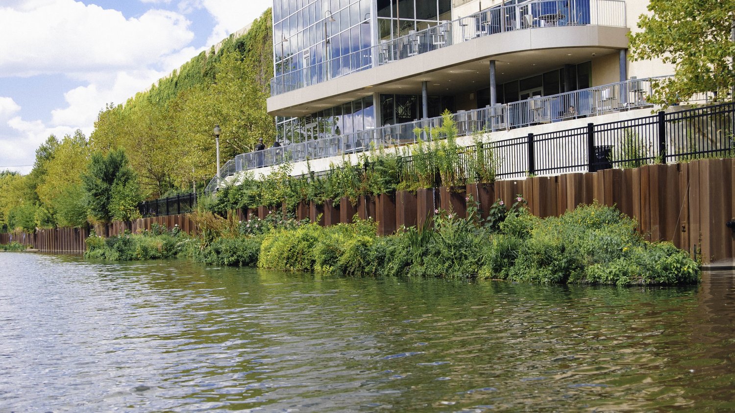
The river was channelized to control flood risk, resulting in the removal of the riparian and emergent landscapes along the Chicago River. The hard walls of the channel and concrete channel itself severely limit the opportunities for vegetation to grow and habitat. Currently, parts of the channel walls are eroding and unstabilized.
As a channelized river, the river is constructed as a transport mechanism for urban runoff. As rainwater runs off urban surfaces, it picks up pollutants that end up contaminating the Chicago River. The river has also become contaminated by untreated water going straight into the river and heavy rains causing sewage to leak into the water. As such, the Chicago River became heavily polluted and toxic for native habitat and species because oxygen levels became so low fish cannot survive.
Defining the Reference Ecosystem
The reference ecosystem is primarily based on historical information about ecological attributes at the site prior to degradation.Reference Ecosystem Description
The Chicago River system is 156-miles of tributaries coming in from the north and northwest side of the city, flowing through downtown Chicago, and exiting the city on the Southwest side. The North Branch channel is the only channel in the city which still flows as it originally did (all other channels were reversed to preserve water quality of Lake Michigan). The project aims to simulate the original riparian wetland habitat that existed along the river as recently as 1904. The river as it naturally occurred would have had a gradated zone of habitat the transitioned between land and water from the upland, to riparian, to emergent, and finally to the aquatic zone. This zone bridges the transition from land to water, stabilizing the the river’s edge, providing quality and diverse habitat, and acting as a buffer for stormwater runoff. The upland habitat is characterized by well-drained soils, and plants that are more tolerant of dry conditions. The riparian habitat is characterized as the seasonal interface between land and water with plants that can tolerate both dry and wet conditions. The emergent landscape grows near shore in shallow water, rooted in river bottom sediment. Aquatic habitat constitutes plants that require an environment permanently saturated with water.
The river would have had sediment and nutrients dissolved in the water to support invertebrates, frogs, fish, and aquatic birds. Nearby land would have constituted of invertebrates, lizards, birds, and small mammals. The Great Blue Heron is a notable native species. Restoration success with be evaluated based on whether multiple trophic levels of species are brought back to the project area through constructing habitat to encourage their return from the bottom up. The restored system will filter/cleanse the river water using native plant roots much in the same way the reference ecosystem would have.
Project Goals
The goal of the Wild Mile Chicago Framework Plan is to create a new environment for (1) habitat, (2) recreation, (3) remediate pollution in the river, and (4) education.
The goal of Wild Mile Chicago is to transform a section of the man-made, steel-walled Chicago River into an eco-park that serves people, wildlife, and the environment. Upon completion in 2020, Wild Mile Chicago will contain floating gardens, forests, wetlands, public walkways, educational learning stations, kayak access points, and more!
The specific objectives were to integrate a variety of open spaces, promote partnerships, coordinate education, cultural and recreational programming, create a sense of place by responding to unique conditions, provide connections using floating boardwalks, enhance and restore riparian and emergent landscapes, improve water quality. Primary principles and goals were to put wildlife first, connect people with nature, expand public access, design a cohesive experience, lead the world, and create a place for everyone.
Monitoring
Stakeholders
Three stakeholder meetings were conducted over the course of the process of evaluating existing conditions, developing a conceptual framework, and listing final recommendations. Stakeholder engagement included continuous meetings organized with adjacent property owners. Community members have been engaged through community feedback both through in person meetings and online form feedback. Three community meetings have been held thus far throughout the planning process to educate interested residents about the objectives and progress of the project. Community members indicated that they were most interested in nature and green spaces (65% of responses), and public paths and accessibility (38% of responses) promoted along the river. In addition to enhancing the ecological habitat, the project will create educational, recreational, and public art opportunities. The project leaders also organized community walking events along the Wild Mile and kayak trips. Local schools were engaged with classroom activities.
How this project eliminated existing threats to the ecosystem:
- "De-channelize" the edges and increases the total surface area of the edges of the waterway by retrofitting them with green buffers (vegetated installations).
- Install dog amenity areas away from habitat areas.
- Introduce habitat with the ability to intercept urban stormwater runoff.
How this project reinstated appropriate physical conditions (e.g. hydrology, substrate)",:
- Alter the vertical walls of the channel to introduce varied hydrology so that the river begins to appear more like a natural winding river than a straight channel.
- Vertical structures underwater will be installed to retain clean sediments in shallow flats.
- Terracing, geotextiles, brush layering, and willow fencing are being used to stabilize soil.
- Along unstable shorelines, concrete mats will be placed to reduce erosion and provide foraging and shelter for invertebrates and small fish during high flow periods.
How this project achieved a desirable species composition:
In 2014, the volunteer-based non-profit Urban Rivers experimented with installing floating rafts with native plants growing into the river to see how the introduction of platforms mimicking natural habitat might increase fish populations compared to fish habitat along the straight walls of the river. This installation led to the Wild Mile project
There will be habitats designed for pollinators like bees and butterflies which in then will create the building blocks for more animals like insects, mussels, fish, turtles, bats, and birds. Research has been done to support methods for creating and sustaining habitat along the river.
Ideas for attracting this fauna include:
- hexagonal apiaries
- floating wetlands
- native plant palettes were chosen based on native status and wildlife value (specific plant palette matrix is available in the additional resources).
- submerged habitats that will artfully peek out of the water
- gourd birdhouses for Purple Martins
- Large submerged concrete tubes for catfish habitat
- Shedd Aquarium will install and care for Shedd's River Island, 260 sq ft of dedicated floating habitat within the Wild Mile. Shedd's River Island features more than 15 strategically chosen aquatic, wetland and terrestrial plant species that provide food and shelter to native wildlife.
- WRD construction installed fish hotels- plastic boxes suspended in water with entry and exit holes.
- Turtles snags have been installed for basking.
- Attempts to find solutions to promote pollinator, bat, and birds populations continue to be explored.
- The University of Illinois is building a bottom-up, trophic-level bat habitat on the Wild Mile’s artificial floating riverbanks in the Chicago River to help sustain urban bat species affected by white nose syndrome and wind turbine fatalities.
- Biofilm and algae will be introduced so a man-made canal will transform into a lush home for plants and wildlife.
- The goal is to eventually attract herons, hummingbirds, butterflies and other “awe-inspiring” animals.
How this project reinstated structural diversity (e.g. strata, faunal food webs, spatial habitat diversity):
One of the most important things is introducing a natural edge back into the canal, ecologists have told the design team. Most healthy rivers have four levels—upland, riparian, emergent and littoral. So with the Wild Mile design, adding floating gardens, shallow pool areas, textured or terraced plant levels to incorporate a faux slope will create a cleaner river.
Retrofit the channelized edge of the river to re-establish natural form and process by creating habitat and intercepting runoff. The project aimed to assess the various edge conditions of the river such as hard walls, to bring in naturalized slopes and shallow edges.
The project has been consulting with experts to understand how to add habitat to vertical walls and the eroded banks along the river. For vertical walls, options are floating platforms, terraced habitat fixed to the wall, or constructed shallow wetlands. For eroded slopes, solutions are rocky habitat installations, terraced habitat, or constructed shallow river habitat.
The native habitat zones were recreated with artificial habitat types including: 1) submersed, 2) emergent, 3) trailing.climbing vines, 4) facultative wetland, 5) pollinator mix, 6) upland drought tolerant, and 7) floating trees.
How this project recovered ecosystem functionality (e.g. nutrient cycling, plant-animal interactions, normal stressors):
Aeration waterfalls will be added into the river to raise oxygen concentration in the river so that fish can thrive. Plants designed to filter out pollutants and floating tree platforms will also restore ecosystem functionality.
How this project reestablished external exchanges with the surrounding landscape (e.g. migration, gene flow, hydrology):
By installing floating platforms with native vegetation, encouraging pollinators, and introducing low trophic level organisms like algae and biofilms, the project aims to support the immigration of native wildlife species which would have existed along the river.
Activities were undertaken to address any socio-economic aspects of the project:
(See socio-economic outcomes)
Ecological Outcomes Achieved
Eliminate existing threats to the ecosystem:
As the project is still on-going, the results of restoration actions are not yet thoroughly realized.
Achieve a desirable species composition:
The initial 2014 study found that the floating platforms of native plants had twice the number of fish compared to walls.
Factors limiting recovery of the ecosystem:
The channel will remain channelized in concrete which will limit the complete restoration and recovery of the ecosystem. Because the river is within a heavily urbanized area, the restoration of the system remains constrained because flood risk and water quality must remain strong considerations.
Socio-Economic & Community Outcomes Achieved
Economic vitality and local livelihoods:
The team leaders identified and worked with the existing uses along the Wild Mile project area and brought adjacent property owners into the planning conversations.
The park will have public walkways to bring life to the community and revitalize businesses along the river’s edge. The project seeks to create a sense of place along the Wild Mile for Chicago residents of all ages and backgrounds by improving and creating access and open spaces all along the project area.
Cultural dimensions such as recreational, aesthetic and/or spiritual:
The project promotes partnerships with local institutions that coordinate educational, cultural, and recreational programming along the river.
Regulation of climate, floods, disease, erosion, water quality, etc.:
Water quality was a key concern for community stakeholders. As the water passes through the roots of the eco-park, the roots absorb the water along with the substances in the water. This process of using plants to naturally clean the waste in the Chicago river is called phytoremediation.
Key Lessons Learned
The initial 1,500 square feet of the park was installed in June 2017 by Urban Rivers. The successes and failures of this initial installation was used to guide the next installations. An educational platform and kayak launch will be completed in Spring 2019. The remainder of the project is set to be completed by next year (2020).
Long-Term Management
Chicago’s Metropolitan Water Reclamation District (MWRD) has partnered with Urban Rivers to conduct a 4-year study measuring the effects of our floating habitat on the populations and health of local fish species. MWRD utilizes electrofishing techniques to safely and efficiently gather fish and benthic organism samples every few months.
The non-profit organization partners with universities and students on research projects to scale impact and insights about the Wild Mile. Research topics include Depaul University students are looking into business implications, Northeastern Illinois University is researching periphyton and performing mesocosm experiments at the Chicago Botanic Garden to better understand the effects of our floating habitat on the river ecosystem. The lab of Dr. Eric Peterson at the Illinois State University is assessing the impact of the floating wetland habitat on water quality metrics (e.g. the levels of nitrogen, phosphorus, chloride) in the area immediately surrounding the installation. Conducting urban bird surveys. The University of Illinois is building a bottom-up, trophic-level bat habitat on the Wild Mile’s artificial floating riverbanks in the Chicago River to help sustain urban bat species affected by white nose syndrome and wind turbine fatalities.
The long-term goal for the US Army Corps of Engineers (USACE) to deauthorize navigation along the North Branch Canal of the Chicago River. In the short-term, the USACE is exploring a programmatic approach to permit habitat restoration and floating walkways.
Sources and Amounts of Funding
The majority of funds were fundraised by the working group. Urban Rivers fundraised over $50,000 on Kickstarter so far. Remainder of funding sources is unknown.
The cost of project components are available under additional resources.
Other Resources
- https://online.fliphtml5.com/pjhnl/xkzl/#p=2
- https://www.fondriest.com/news/chicago-rivers-wild-island-bringing-back-healthy-waters.htm
- https://www.citylab.com/environment/2018/08/fake-riverbanks-turn-a-chicago-canal-wild/565985/
- https://blockclubchicago.org/2019/04/26/design-for-wild-mile-on-chicago-river-unveiled-to-community/
- https://www.urbanriv.org/
- https://www.wildmilechicago.org/
- https://static1.squarespace.com/static/5bd345777980b336a99b9740/t/5bfdd1ec8a922d05c3bbdae8/1543361021000/20181126_Wild+Mile+Community+Meeting+1_Presentation.pdfhttps://static1.squarespace.com/static/5bd345777980b336a99b9740/t/5c61da96e2c4831e6d45d7aa/1549916841704/20190207_Wild+Mile_Community+Meeting+2_Final+Presentation.pdf