
Overview
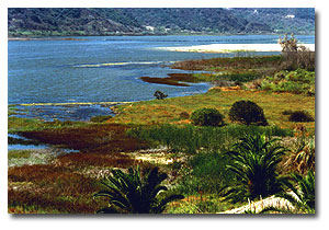
Batiquitos Lagoon is a coastal lagoon located in the southern part of California just 35 miles (56.3 km) north of San Diego city. During the 20th century many transportation routes had been built across the mouth of the Batiquitos Lagoon, cutting the lagoon off from the ocean. This included three transportation corridors (a railroad bridge, the Pacific Coast Highway, and Interstate 5) that were constructed across the lagoon. These corridors constricted the tidal flow of water in and out of the lagoon. Additionally, agriculture and urban development in the watershed area caused a significant influx of fine sediment into the lagoon. Heavy agricultural and residential land uses in the 30-square-mile (77.6 kmÁ‚²) watershed were the source of significant nutrient loading from fertilizers and runoff. All these factors contributed to the degraded state of the lagoon and the closure of the tidal inlet.
With the connection to the ocean lost, the lagoon’s water became less saline and sediment began to accumulate, reducing the lagoon’s habitat value for plant and wildlife species. The interface between salt and fresh water creates an ecosystem unique to lagoons because they are both nutrient rich and sheltered from wave action. In addition, due the change in elevation from the lagoon’s water surface to the top of the lagoon’s banks there are three general habitat types; 1) upland habitat, 2) intertidal habitat, and 3) open water (listed from highest to lowest in elevation). Each habitat houses its own plant, fowl and/or fish wildlife.
The ဘupland’ plant habitat consists of; scrub, grassland, willow, riparian, un-vegetated sand flat, and saline meadow. The birds in the upland area are bullock’s oriole (Icterus bullockii), western kingbird (Tyrannus verticalis), warblers, and black-headed grosbeak (Pheucticus melanocephalus) and other large birds such as raptors. In the intertidal environment the plant life includes; salt marsh, brackish marsh, freshwater marsh, algal beds, mudflats, and salt panne. The birdlife entails both wading and shore birds, and water fowl, such as mallard ducks (Anas platyrhynchos). ဘOpen water’ habitat type is characterized more by its physical characteristics than by the plants and birds that live in it. Based on these physical characteristics, this habitat can be subdivided into three areas: 1) salt water lagoon, 2) near shore, and 3) fresh water. Some fish species that are commonly found in open water habitat are the ဘaerial fish foragers’, for whom catch fish by flying low over the water to locate their food and then diving into the water to capture it. These aerial fish foragers include; pelicans, terns, and kingfishers. The lagoon fish community supports three guilds of fish: 1) Pelagic fish (fish that live and feed primarily in the water column, such as smelts), 2) Demersal fish (fish that live and feed primarily along the bottom, such as rays) and, 3) Structured-habitat fish (fish that use underwater structures, such as rock pilings and eelgrass).
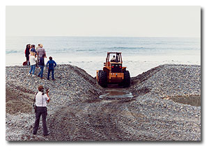
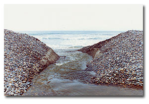
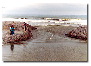
Although once a ဘtidal system’, Batiquitos Lagoon has remained largely un-tidal for the last 90 years. By the early 1980’s, the lagoon had achieved an advanced state of sediment infilling and eutrophication resulting in serious natural habitat declines. In 1997, the Port of Los Angeles et al. began the environmental restoration of Batiquitos Lagoon. Since the end of construction, the ecosystem of the lagoon has gradually changed from a confined non-tidal system with limited habitat value to fully tidal, salt water system with greater habitat value.
The major construction process involved:
– dredging sand from the central basin for use in beach replenishment and creation of tern colonies (1994-1995)
– placement of fine sediment materials dredged from the eastern basin into the central basin borrow pit and construction of the lagoon mouth jetties (1995-1996)
– capping the central basin borrow pit, containing fine sediments, with sand dredged from the western basin.
The minor construction process involved:
– remove and re-contour an access ramp in the eastern basin
– plant pickleweed (Salicornia europeae) along parts of the northern shore of the eastern basin
– remove an undesirable underwater ridge in the entrance channel of the lagoon
– weed and repair erosion damage on tern colonies and prepare colonies for the 1997 nesting season
– enhance the facing of the railroad bridge abutments
Quick Facts
Project Location:
Batiquitos Lagoon, California, USA, 33.0892947, -117.2925942
Geographic Region:
North America
Country or Territory:
United States of America
Biome:
Coastal/Marine
Ecosystem:
Estuaries, Marshes & Mangroves
Area being restored:
30.48 (78.9428) square miles (sq.km)
Organization Type:
Governmental Body
Location
Project Stage:
Implementation
Start Date:
1994-03-17
End Date:
1996-12-17
Primary Causes of Degradation
Agriculture & Livestock, Urbanization, Transportation & IndustryProject Goals
_
Monitoring
The project does not have a monitoring plan.
Stakeholders
– Port of Los Angeles
– City of Carlsbad
– California Department of Fish and Game (CDFG)
– U.S. Fish and Wildlife Service (USFWS)
– U.S. National Marine Fisheries Service (NMFS)
– California State Lands Commission
– KTU+A
Description of Project Activities:
March 1994 to December 1996 involved actual construction. According to the 2001 Report, monitoring of the project started in 1997, and was to continue for 10 years, till 2007.
Ecological Outcomes Achieved
Eliminate existing threats to the ecosystem:
Vegetation: As expected, total acreage of coastal salt marsh within the lagoon has increased during each monitoring year from 1997 through to 2001 (largest gain in 1999). The primary gain in coastal salt marsh has resulted from the conversion of brackish marsh, mudflat, algal bed, and freshwater marsh.
Avian community: Batiquitos Lagoon supports a rich avian community comprised of migratory and resident species which are extremely variable in their seasonal abundance. The numbers of individual present within the lagoon during 2001 was lower than in previous years; however, overall numbers went up a great deal as compared to post-restoration. Due to seasonal migration patterns as factor driving avian into the lagoon, the months of January and October proved to have the greatest numbers of all monitoring years. Additional influences over variation and numbers in the avian group was the reduction of brackish marsh conditions and the development of mudflat and coastal salt marsh communities. However, the utilization of mudflats (primary users are shorebirds) declined by 2001. This may be contributed to predation and lack of nesting colony maintenance.
Fish: Prior to restoration, water salinities within the lagoon were low, ranging from fresh to brackish. As a result fish species captured within the lagoon have historically (i.e. 1984) been brackish or freshwater species. They have since been displaced by a predominantly marine system.
There were water quality improvements concerning salinity. During 1979 to 1982, water salinities were estimated to average between 0 and 10 ppt during the winter months (nearly a freshwater lake), and during the summer months salinities averaged between 30 and 40 ppt (2 to 4 times that of sea water), and during drought years as high as 100 ppt. During 1998 through 2001, the salinities within the lagoon remained similar to oceanic water salinities.
Pilot vegetation program: introduction of cordgrass and eelgrass was a success.
Socio-Economic & Community Outcomes Achieved
Long-Term Management
The long-term biological monitoring is being carried out by the City of Carlsbad and the Port of Lost Angeles in coordination with agencies including USFWS, CDFG, and NMFS.
The monitoring program for the lagoon will consist of quarterly, semiannual, and annual sampling activities to be conducted in years 1, 2, 3, 5, and 10 following lagoon restoration (starting January 1997).
Some goals of the monitoring include:
– fulfill conditions associated with the various project approvals, and mitigation agreements
– record changes in the ecology of the lagoon environment over time
– provide timely identification of any problems with the physical, chemical, and/or biological development of the lagoon; and,
– assist in providing a technical basis for resource management, recording maintenance needs and enhancement opportunities
Sources and Amounts of Funding
Almost 57 million USD