
Overview
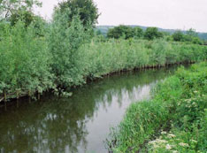
The River Dulais in Southwest Wales was the site of a restoration project implemented by the Environment Agency Wales (EAW) to increase bankside vegetation and curb extensive streamside erosion resulting from livestock grazing. Although conventional methodologies would require the use of stone revetments and other costly interventions for this type of restoration, EAW opted instead to utilize less-intrusive bioengineering techniques that would counter the erosion while encouraging natural re-vegetation and overall enhancement of habitat value. Thus, coir rolls, live willow bundles, and rootwad revetments were used in varying combinations with fencing and bank grading in order to tailor intervention measures to particular stream-reach characteristics and erosive processes operating thereon. Living bundles installed as part of the project have exhibited high rates of survival, and colonisation by natural vegetation has exceeded prior expectations. EAW is pleased with the outcome of the project and is using it as a test site to demonstrate the efficacy of these techniques.
Quick Facts
Project Location:
River Dulais, Neath, Wales, UK, 51.7310817, -3.7326170999999704
Geographic Region:
Europe
Country or Territory:
United Kingdom
Biome:
Freshwater
Ecosystem:
Freshwater Rivers & Streams
Project Lead:
Environment Agency Wales (EAW)
Organization Type:
Governmental Body
Location
Project Stage:
Completed
Start Date:
2003-01-06
End Date:
2006-01-06
Primary Causes of Degradation
Agriculture & LivestockDegradation Description
The River Dulais is typical of many rivers in the area, where unrestricted grazing, mostly by sheep, has resulted in a loss of bankside vegetation, reduced cover for fish, bank/bed instability and increased erosion.
Project Goals
– Stabilise reaches of highly mobile channels using diverse bioengineering/soft revetments.
– Enhance physical habitat structure to benefit fish, primarily migratory salmonids.
– Allow subsequent natural channel readjustment (e.g. natural narrowing of over wide reaches and self cleansing of gravel bed).
– Demonstrate that bioengineering techniques (i.e. soft engineering) can be used as an alternative to blockstone in mobile gravel-bed rivers to control erosion whilst restoring physical habitat to degraded channels and thus helping to guarantee the sustainability of fish stocks in Wales.
Monitoring
The project does not have a monitoring plan.
Description of Project Activities:
Traditionally, blockstone revetments would be used in higher energy rivers to control bank erosion. However, blockstone removes any scope for marginal grasses and trees to establish, thus lowering the ecological value of the river and also reflects the flow of water, which causes additional instability downstream.
Environment Agency Wales was keen to demonstrate that softer bioengineering methods could be used that would control the extensive erosion, whilst maintaining geomorphological processes, and enhancing the physical habitat of the river.
Salix River & Wetland Services was hired to conduct a detailed geomorphological survey in order to ascertain the erosion processes at work, rates of planform adjustment, estimated discharge at bankfull, and the estimated erosive energy potential of the river by calculating stream power and shear stresses applied to the bed and banks of the river during bankfull events.
Salix also provided a detailed design plan for restoring the river using bioengineering techniques. In order to maintain and enhance local biodiversity all living plant material was harvested from the Dulais and adjacent catchments. The desired vegetation types were deemed to be a mix of marginal grasses (Phalaris arundinacea, Juncus effusus) and tree cover (Salix cineria & Salix fragilis).
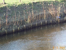
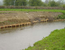
Several bioengineering techniques were employed based on the local reach-scale erosion process, water depth and stream power. For example, in reaches with slack bed gradients, and therefore reduced stream power, simple low cost techniques were used, such as bank grading and toe protection using live willow bundles (faggots/fascines). The entire reach was fenced in order to keep livestock off the banks.
In deeper areas, outer meander bends and reaches with steeper bed gradients, and therefore more erosive energy, more robust techniques were used. Whole upturned tree roots with 2 metres of trunk still attached were installed to act as physical revetments and also deflect flow away from eroding banks. In total, some 40 large tree roots were installed in the deepest and most unstable reaches. All the trees used were grey willow (Salix cinerea) and, as such, have started to grow, providing excellent habitat and cover.
The following is a summary of specific techniques used in different reaches, according to the characteristics of the particular reach:
- For reaches with a bed gradient of 0.011-0.014 and an average bankfull velocity of 2.1 m/s, pre-planted coir rolls were used.
- For reaches with a bed gradient of 0.015-0.018 and an average bankfull velocity of 2.5 m/s, willow faggots were installed.
- For reaches with a bed gradient of 0.019-0.022 and an average bankfull velocity of 2.95 m/s, live brush packing was used.
- For reaches with a bed gradient of 0.023-0.026 and an average bankfull velocity of 3.3 m/s, rootwads and brush packing were used in combination.
Ecological Outcomes Achieved
Eliminate existing threats to the ecosystem:
Approximately 90% of all living material planted has survived, and a diverse mix of other vegetation species has colonised. All parties involved in the restoration have been surprised by the rate of establishment of the bioengineering revetments and also the diverse range of bankside grasses and other species which have colonised around the tree roots. Indeed, after one year, the reaches have diverse bankside cover, cleaner gravels with less fine sediment, early stages of tree cover and channel geometry that is much closer to adjacent stable reaches of river.
Socio-Economic & Community Outcomes Achieved
Key Lessons Learned
The EAW is delighted with the results of this project and is using the project as a test site to demonstrate the use of sustainable river management techniques.
Long-Term Management
The EAW is keen to demonstrate the (cost) effectiveness of these restoration techniques and, as such, is monitoring both fish populations (using fully quantitative electrofishing surveys) and habitat (HABSCORE) at these survey sites. Prior to commencement of the restoration work, three 50-m sites were monitored within the affected reach, and another three were surveyed upstream to act as controls. This baseline data will be followed with subsequent surveys in the spring/summer of 2006. Given the obvious improvements to in-river and bankside habitat, it is expected that these surveys will reveal an increase in fish populations at the site.
Besides erosion-control measures taken in association with this project, EAW has worked with local landowners over the last three years to fence off and protect some 4.9 km of the river.
Sources and Amounts of Funding
5.2 million Pounds (£) This project qualified for Objective 1 funds, which were provided through the Sustainable Fisheries Programme of the Welsh Assembly Government.
Other Resources
Environment Agency Wales
http://www.environment-agency.gov.uk/?lang=_e