Overview
On June 26, 1998, the Connecticut Department of Environmental Protection (CTDEP) issued a Consent Order to the University of Connecticut (UConn) requiring that a remedial action plan (RAP) be formulated to abate pollution emanating from the university’s landfill and former chemical pits, which operated between 1966 and 1993. The disposal areas became sources of contamination of wetland sediments, surface water, and domestic wells through the migration and discharge of leachate-contaminated groundwater. Actions necessary to close the landfill, treat leachate, and remove contaminated sediments required the unavoidable disturbance and/or loss of adjacent freshwater wetlands—a violation of Section 404 of the Clean Water Act. UConn was issued a permit by the Army Corps of Engineers (ACOE) and CTDEP requiring that wetlands be restored and/or created as compensatory mitigation, and that there be no net loss of wetland area, function, or value. Mitigation activities resulted in greater than 1:1 areal compensation (1.02) of wetland disturbance/losses; wetlands of greater diversity (biological and physical), function, and value than pre-restoration conditions; and the establishment of a conservation area that is used recreationally and educationally by the local and UConn communities. Thorough annual monitoring and adaptive management were key to the success of this project.
Quick Facts
Project Location:
University of Connecticut, 41.8077414, -72.25398050000001
Geographic Region:
North America
Country or Territory:
United States of America
Biome:
Freshwater, Temperate Forest
Ecosystem:
Freshwater Wetlands, Freshwater Rivers & Streams, Temperate Forest - Deciduous, Other/Mixed
Area being restored:
17.71 hectares
Project Lead:
Mason and Associates, Inc.
Organization Type:
Consultant / Consulting Company
Project Partners:
The project has been a collaborative effort by the following:
Technical Review / Permitting
-Connecticut Department of Energy and Environmental Protection (CTDEEP) – Formerly CT Department of Environmental Protection (CTDEP)
-US Army Corps of Engineers (ACOE)
-US Environmental Protection Agency (EPA)
-US Fish & Wildlife Service (USFWS)
Investigation Team
-University of Connecticut (UConn) – Architecture & Engineering Services; Office of Environmental Policy
-Haley and Aldrich, Inc. (H&A) - hydrogeology, engineering, project management
-Mason & Associates, Inc. (M&A)– wetland restoration, mitigation
-US Geological Survey (USGS)- Office of Groundwater (OGW) Branch of Geophysics – geophysics and discrete-zone hydraulic characterization
-Environmental Research Institute, UConn – analytical support
-Phoenix Environmental Laboratories, Inc. – analytical support
-Epona Associates, LLC -risk assessment/editing
-Regina Villa Inc. - public relations
-Mitretek Systems - 3rd party review
Location
Project Stage:
Monitoring & Evaluation
Start Date:
1998-06
End Date:
2008-05
Planning \ Design:
72
Implementation:
24
Post-Implementation Maintenance:
120
Monitoring & Evaluation:
120
Primary Causes of Degradation
Agriculture & Livestock, Contamination (biological, chemical, physical or radiological), Invasive Species (native or non-native pests, pathogens or plants), Mining & Resource ExtractionDegradation Description
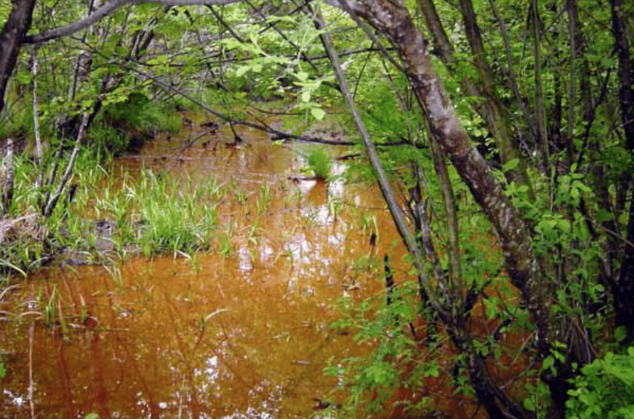
The UConn landfill was operational between 1966 and 1993 and was filled primarily with paper (85%) and mixed refuse (15%-chemicals and trash). Organic solvents, chlorinated hydrocarbons, pump oils & aromatic hydrocarbons, and herbicides & pesticides were deposited in adjacent chemical pits that operated between 1966 and 1987. The waste disposal areas were unlined, which meant that rainwater infiltrating though the landfill and chemical pits produced leachate that was contaminating nearby groundwater, surface water, and sediments with heavy metals, volatile organic compounds (VOCs), dense non-aqueous phase liquids (DNAPLs) and other chemicals. In the adjacent wetlands, toxic metals were precipitating on wetland sediments (see Figure 3). Although Haley & Aldrich (H&A) conducted formal assessments of the impacts of groundwater and sediment contamination, no formal assessment of the impacts of the contamination on biota was conducted. However, the bioaccumulative properties of heavy metals in plants and animals and their negative impacts to human health are well-understood and documented. Some homes to the west of the landfill are connected to UConn water because of historic well contamination with chemicals traced back to landfill leachate. The concern of the local and university communities for their health and well-being garnered widespread support for the remediation project in the context of the contamination. The restoration of the wetlands was not a community focus per se, but it was a necessary part of the remediation process from both an ecological and regulatory perspective.
Other causes of degradation to the wetlands stem from UConn’s role as a land grant agricultural university. Farming activities for the university began in the 1800s, which involved clearing of land near the wetlands, agricultural nutrient runoff, drainage of wetlands in certain areas, and the development of university facilities nearby. Sand and gravel mining activities also used to occur in the glacial till deposits located in the conservation land that was established during this project (the HEEP). These activities required the building of temporary roads adjacent to and through some portions of wetland, which had hydrologic impacts.
Wetland areas closest to the landfill were especially degraded pre-restoration. Some areas were heavily invaded by Common Reed (Phragmites australis) and Reed Canary Grass (Phalaris arundinacea). Approximately 82% of the wetland area expected to be lost through remediation activities was considered degraded according to the functional assessments conducted by Mason and Associates, Inc. (M&A). A primary goal for the wetlands created/restored through this project was that they have greater functional value than the pre-restoration wetlands.
Defining the Reference Ecosystem
The reference ecosystem is primarily based on contemporary reference sites or existing analogues of the pre-degradation ecosystem.Reference Ecosystem Description
Considering the extent and legacy of historic degradation of the wetlands at the site and the expected impacts of the landfill remediation activities on the wetlands, restoring to a historic ecosystem was deemed impractical. Historic aerials of the site reveal drainage ditches, fill roads, and beaver activity that have altered wetland hydrology and changed vegetative communities profoundly since the 1800s. The landfill closure plan was expected to result in wetland losses through direct filling and indirect hydrologic modification, requiring the creation of new wetlands as part of the wetland mitigation plan and regulatory compliance.
Baseline studies of wetlands to be restored/lost provided the information on plant community types and flora subsequently used to plan restoration & creation sites. The restored/created wetlands would have a species assemblage characteristic of wetlands of the northeastern US, be delineable, and be classified as their planned habitat type as described in the Classification of Wetlands and Deepwater Habitats of the United States (Cowardin et al. 1979) (PFO-Palustrine Forested, PSS-Palustrine Scrub-Shrub, PEM-Palustrine Emergent, PAB-Palustrine Aquatic Bed). To gauge restoration/creation success, fundamental wetland attributes, including dominance of native hydrophytic vegetation, proper hydrologic regime for the intended wetland habitat, and hydric soil development were evaluated.
Increasing wetland functions and values was a priority in the planning and design of the mitigation wetlands. M&A performed functional assessments of the wetlands before and after restoration using the Highway Methodology. Mitigation wetlands were to have greater functions and values than their pre-restoration condition.
Project Goals
Remediation Goals:
- Characterize contaminant sources, extent, and migration pathways per the Consent Order
- Eliminate leachate discharge to surface waters
- Protect public health by mitigating or containing contaminants that threaten domestic wells
- Wetland mitigation (restoration & creation) – see below
The compensatory mitigation plan included a combination of wetland restoration, wetland creation, wetland enhancement, and preservation of adjacent uplands to fulfill the overarching mitigation goals:
- No net loss of wetland area, functions, or values
- Restoration of wetland habitats disturbed by sediment remediation
- Creation of wetland with reliable source of wetland hydrology
- Buffering natural and created wetlands from human activity
- Enhancement of wildlife habitat
- Vernal pool creation (added post-2004 mitigation plan, per USFWS suggestion during the permitting process)
- Control of problem invasive and exotic plant species
- Practicable, cost-effective construction
Socio-economic
- Development of a conservation area that could be used recreationally and educationally by the local and UConn communities
Monitoring
Monitoring Details:
ACOE required that UConn provide annual monitoring reports for 5 years post-construction per the Section 404 permit.
CTDEP required that UConn provide annual monitoring reports for 10 years post-construction.
Preliminary assessments of the contamination began in the late 1980s, but more thorough studies of the extent of the soil, surface, and groundwater pollution began after CTDEP issued UConn a Consent Order on June 26, 1998. H&A conducted a comprehensive hydrogeologic investigation to understand groundwater movement at the site and determine the identity and movement of contaminants emanating from the landfill. They also determined the extent of the sediment contamination. In 2003, M&A delineated and mapped wetland boundaries and performed functional assessments of the wetlands. In addition, they conducted baseline studies of the wetlands to be restored/lost to provide information on plant community types and flora for vegetation planning of the mitigation wetlands.
Start date, including baseline data collection:
Baseline Collection-June 1998, Monitoring began-May 2008
End Date:
Federal ACOE Monitoring-Summer 2013, State CTDEEP Monitoring-Summer 2017
Stakeholders
The primary stakeholders of the project included the UConn community, neighborhood residents, the Town of Mansfield, CTDEEP, and ACOE.
There has been a long-term public outreach – public information program for the landfill remediation project. All the progress reports and monitoring reports related to landfill closure and mitigation activities were made accessible online to the stakeholders. Earlier in the project during remediation activities, a series of newsletters and “reader’s guides” were published to summarize the detailed reports, provide updates, explain procedures, define terms, and provide the contact information of project members who could be reached to answer questions.
Public information meetings, hearings, and the project website were used to inform and gather opinion from the public. Agency stakeholders were also highly involved in the permit process. The stakeholders reviewed and gave feedback on the series of mitigation alternatives presented in the Conceptual Wetland Mitigation Plan before being incorporated in the final permit application. The project was also the subject of land use planning meetings held by UConn with the Town of Mansfield.
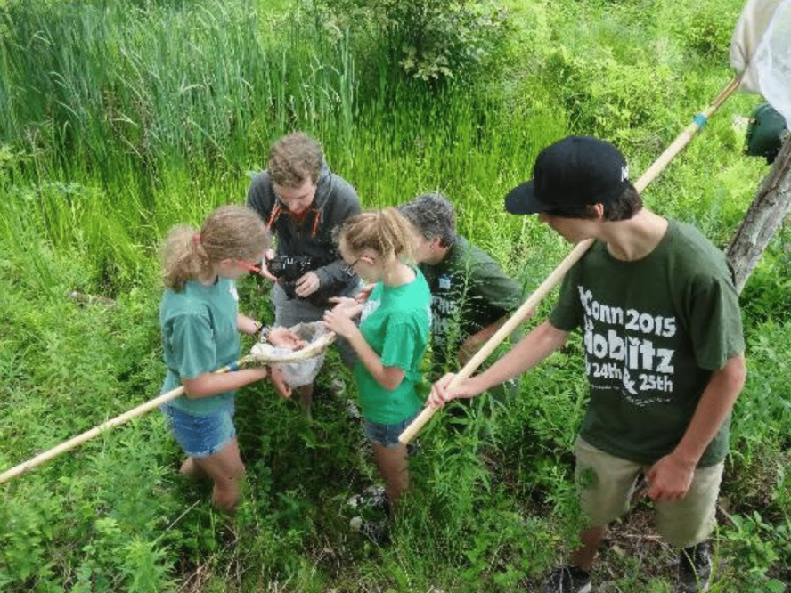
There has also been an educational outreach effort to involve faculty and students in the restoration project. The site has been used as an outdoor classroom for wetland, wildlife, forestry, ornithology, and environmental engineering classes. The site was part of the 2015 BioBlitz held at UConn, which included biodiversity surveys with young children and their families at one of the restoration sites (see Figure 4). Several undergraduate and graduate students have done projects involving restoration site monitoring.
Description of Project Activities:
Post-restoration results (as of 2016 monitoring report):
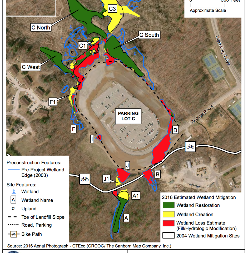
• 1.31 hectares (3.23 acres) wetland restoration
• 0.82 hectares (2.03 acres) wetland loss
• 0.84 hectares (2.08 acres) wetland creation (1.02:1 compensation)
• 366 meters (1200 feet) stream restoration
• 5.02 hectares (12.4 acres) invasive species control
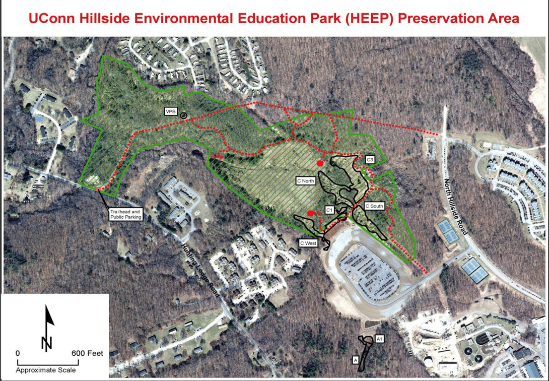
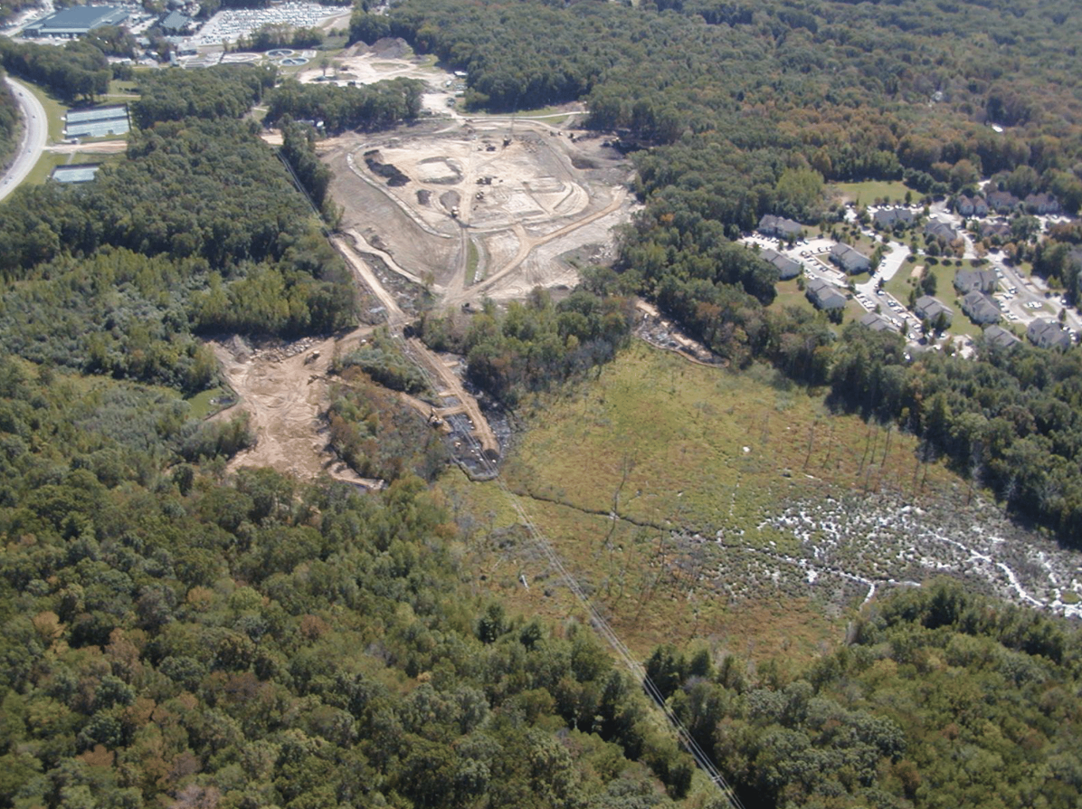
• Entire project area (HEEP – Hillside Environmental Education Park): 26.30 hectares (65 acres)
See Figure 1 for a detailed map of the mitigation areas.
See Figure 2 for a map of the entire HEEP area.
How this project eliminated existing threats to the ecosystem:
H&A planned and implemented several actions to properly close the landfill, eliminate existing contamination, and effectively prevent future contamination of the ecosystems adjacent to the site.
After receiving permits from ACOE and CTDEP, sediments were removed from contaminated wetlands and placed on top of the landfill within the landfill footprint. Those wetlands that underwent contaminated sediment removal were the focus of wetland restoration activities for this project. In addition to removing contaminated sediments, debris and trash were removed from adjacent wetlands and placed on the landfill. To accommodate the volume of material added to the landfill, the slopes of the landfill had to be regraded, requiring the filling of wetlands adjacent to the landfill. To compensate for the wetland losses, wetlands were to be created at a 1:1 (loss:creation) areal compensation ratio, as per the regulations and agreements in the permit.
H&A installed leachate interceptor trenches (LITs) adjacent to the north and south edges of the landfill to collect contaminated groundwater and direct it to UConn’s Water Pollution Control Facility for treatment. The diversion of leachate was expected to cause loss of wetlands whose hydrology was dependent on groundwater discharged from the landfill. The combined loss of wetlands from both direct filling and indirect hydrologic modification totaled 0.82 hectares (2.03 acres), requiring 0.82 hectares (2.03 acres) of wetland creation/compensation per the ACOE permit.
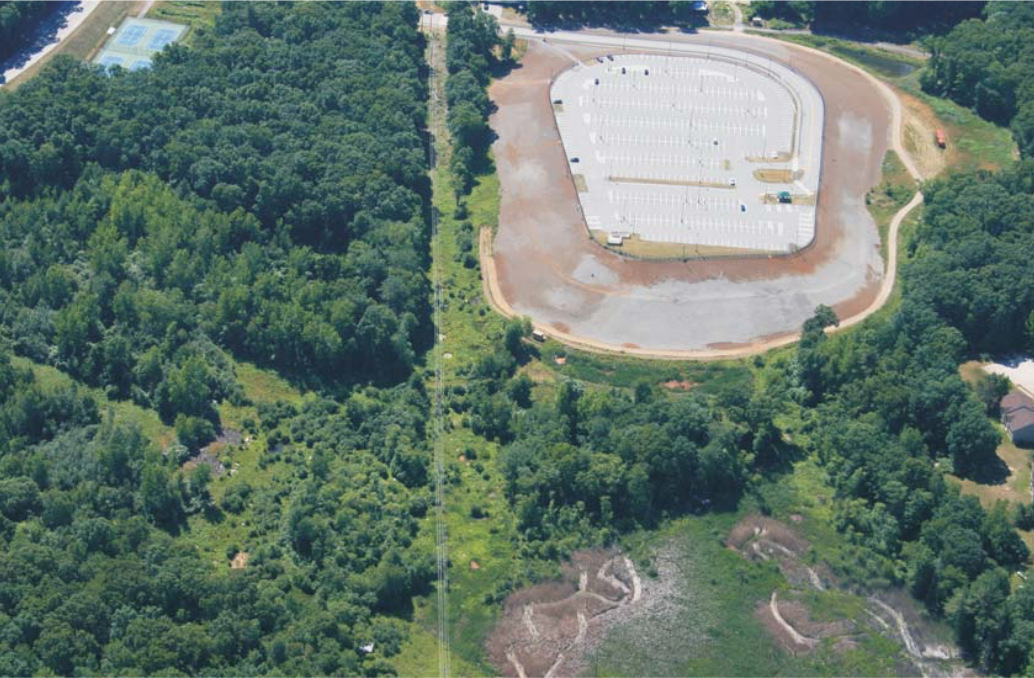
The landfill was capped with earth fill, a geocomposite drainage net (to collect gases generated by the landfill), a polyethylene flexible membrane liner (highly impermeable layer), non-woven geotextile, crushed stone, and asphalt to reduce infiltration into the landfill and direct leachate into the LITs instead of the environment. The UConn community now uses the top-most asphalt layer as a parking lot.
How this project reinstated appropriate physical conditions (e.g. hydrology, substrate)",:
The hydrology of the wetland mitigation areas was expected to be driven by groundwater, which requires proper interception of the water table. H&A used their preliminary hydrogeologic data to model the groundwater regime post-landfill closure, taking into consideration the groundwater flow/budget alterations imposed by the LITs. M&A considered the location of the water table in combination with the type of wetland habitat (ex. emergent marsh, wet meadow, shrub/forested swamp) they intended to create in particular areas of the site to plan the elevation of the wetlands. A wetland’s elevation in relation to the water table affects its hydroperiod, which ultimately determines the vegetative communities that can exist. Similarly, for the vernal pool creation, pools were dug to depths that would support a hydroperiod conducive with breeding by specialist amphibians. M&A installed groundwater wells, staff gauges, water level sensors, and soil moisture sensors to monitor ground and surface hydrology, especially in potentially problematic areas like the wetland creation sites at higher elevations and those wetlands near the LITs.
New soil had to be brought into the wetland mitigation sites to replace the contaminated sediments. The ACOE recommends that topsoil used in wetland creation/restoration/enhancement have 6-21% organic matter (by weight) minimum. A mixture of mineral soils, excavated from the wetland creation areas, and organic soils, derived from the buried organic deposits of a nearby filled wetland on the UConn campus, was laid 1-2 feet thick in the wetland restoration and creation areas, depending on the water table depth and desired wetland habitat. Manure from UConn agricultural facilities and compost were also used as soil amendments in order to meet the 8.6% OM criterion for emergent wetland areas and 20.6% OM criterion for forested areas. Using locally sourced soil material was a more cost-effective option.
How this project achieved a desirable species composition:
Over 20 species of hydrophytes were planted in the wetland mitigation areas as part of the revegetation plan. Since the reference system for this project was contemporary, M&A sought to achieve high native plant diversity and expected and encouraged species from nearby, undisturbed reference wetlands to establish in the mitigation wetlands. M&A also considered the intended wetland habitat and natural wetland plant succession when making planting decisions and when monitoring vegetation changes and trends post-restoration.
M&A established 52 permanent vegetation plots in the mitigation sites to monitor trends in vegetation succession and determine % cover, % hydrophytes, % invasive species, and # of woody plants greater than 18” tall from year to year. 8 plots were also established in nearby reference wetlands to monitor intended plant community development and volunteer species establishment in the mitigation wetlands. M&A performed comprehensive reconnaissance of wetland vegetation in each mitigation site annually to assess overall species abundance, identify unknown species, and monitor invasive species occurrence. M&A carried out a combination of hand pulling and spot herbicide (glyphosate) application to control invasive plants, including: Common Reed, Reed Canary Grass, Multiflora Rose (Rosa multiflora), Glossy Buckthorn (Rhamnus frangula), Purple Loosestrife (Lythrum salicaria), Autumn Olive (Elaeagnus umbellata), and Japanese Stiltgrass (Microstegium vimineum) among others. More extensive, aggressive spraying activity occurred in wetlands invaded heavily by Common Reed; sometimes requiring the use of tracked vehicles to reach deeper into large stands. Regrowth of native vegetation was monitored and documented.
How this project reinstated structural diversity (e.g. strata, faunal food webs, spatial habitat diversity):
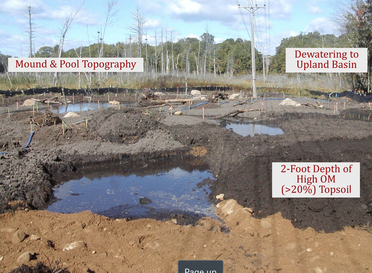
The original mitigation plan required that the mitigation wetlands have greater habitat/spatial diversity than their pre-restoration condition to promote wildlife habitat. M&A designed wetlands with mound and pool topography (see Figure 5) with pools of varying sizes and depths to support different hydroperiods, which dictates what species can utilize certain pools and when. Hydroperiod diversity also influences the types of vegetative communities that can exist in certain areas. Emergent marshes are generally composed of herbaceous vegetation with relatively uniform vertical structure, whereas scrub-shrub and forested swamps have spatial diversity vertically due to the occurrence of multiple vegetation types: short herbaceous emergents, moderately tall shrubs, and tall trees. Special habitat features like standing snags, logs, stumps and root wads, sandy areas, boulders, and rock piles were also added to increase microhabitat. As per the ACOE permit and mitigation standards, at least 2% of the mitigation area had to be covered with coarse woody debris. After mitigation construction, the total surface area covered with coarse woody debris was closer to 4%.
When restoring the streams, M&A designed streams with riffles and pools, different substrates (cobble, sand, mud), and varying degrees of flow duration and sinuosity.
The conservation land established adjacent to the mitigation sites also contains a variety of upland and wetland habitats.
How this project recovered ecosystem functionality (e.g. nutrient cycling, plant-animal interactions, normal stressors):
As part of the ACOE permit, restored/created wetlands needed to have greater functional value than their pre-restoration condition, which M&A determined using the Highway Methodology.
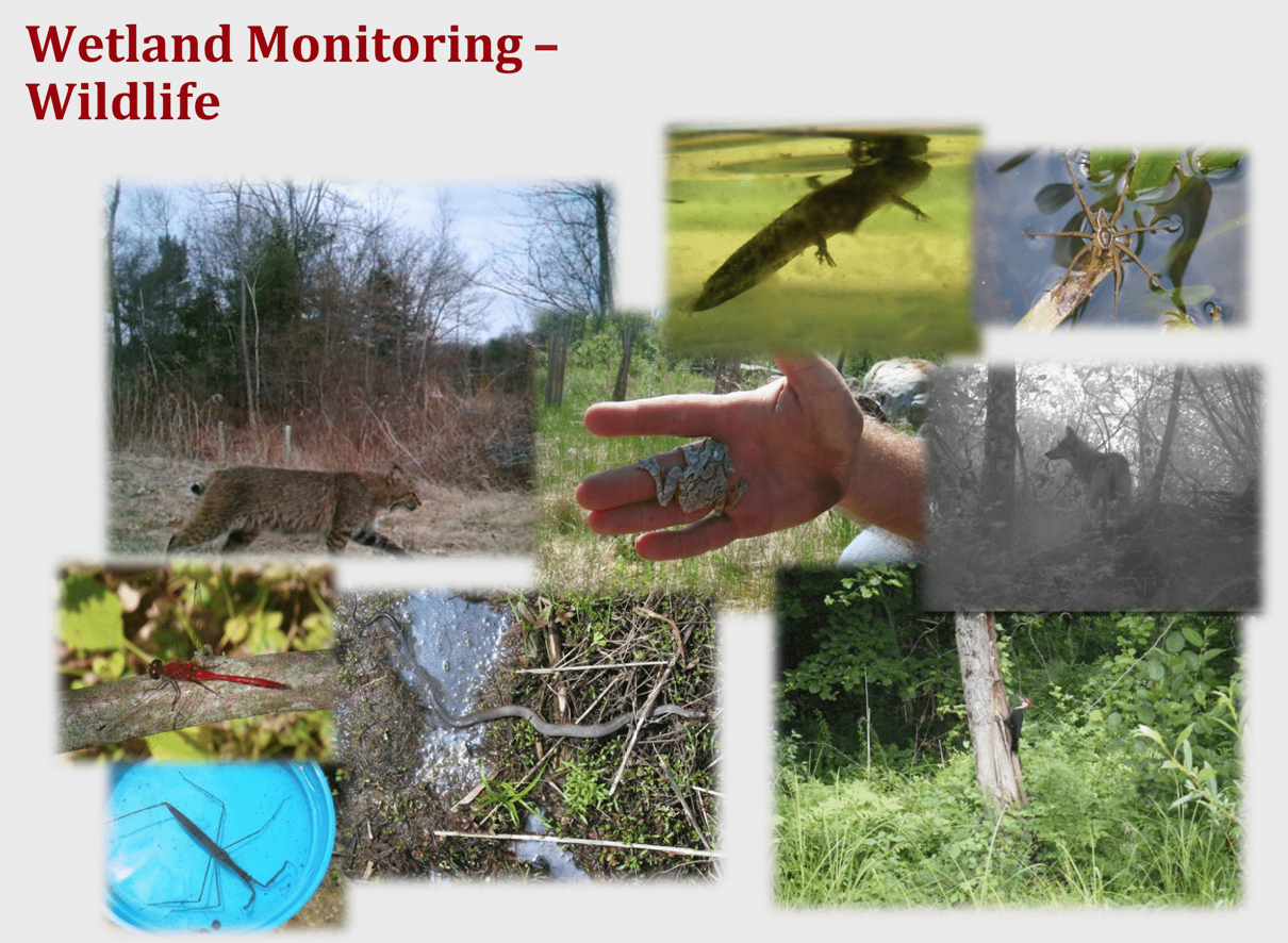
Special habitat features like standing snags, logs, stumps and root wads, sandy areas, boulders, and rock piles were added to provide nesting, cover, basking sites, thermal refugia, and other functions for certain species. M&A identified wildlife by sight, photograph, sound, track, scat, and egg and skull morphology during site visits to determine occurrence and assess the value of the mitigation wetlands for wildlife habitat.
Establishing proper hydroperiods in the mitigation wetlands influences decomposition rates of organic matter and reestablishes the wetland function of carbon sequestration. The degree and duration of inundation is a key stressor in wetland systems that influences wetland chemistry, which ultimately directs nutrient cycling and the occurrence of hydrophytic vegetation. M&A included wetland vegetation that could provide cover, food (ex. Highbush Blueberry, Vaccinium corymbosum; Arrowwood, Viburnum dentatum), or other services to wildlife for the vegetation plan.
How this project reestablished external exchanges with the surrounding landscape (e.g. migration, gene flow, hydrology):
The 65-acre (26.30-hectare) HEEP conservation area was established to buffer human activity, but it would also act as a permanent habitat patch for species dispersal through the moderately developed surrounding area, which includes the UConn campus and residential neighborhoods. It would also provide valuable upland habitat for those species that use resources from or have life history stages requiring both wetland and upland habitat.
Approximately 1200 feet of streams were expected to be impacted by the sediment remediation, filling activities, and hydrologic modification associated with the landfill closure. Stream losses were compensated for at a 1:1 ratio. M&A surveyed and described the original streams so that their properties (substrate, sinuosity, ephemerality) and connection between wetlands could be replicated in the mitigated wetlands.
Activities were undertaken to address any socio-economic aspects of the project:
Properly capping the landfill and redirecting and treating leachate were necessary to ensure safety of domestic groundwater for human consumption and safe physical access to the wetlands. To address and alleviate the concerns of the public, a series of public hearings were held pre-restoration. Also, all the progress reports and plans related to the landfill closure and mitigation activities were made accessible online to the public. In the early stages of the project, a series of newsletters and “reader’s guides” were written meant to summarize some of the material in the lengthy reports, provide updates, define terms, offer a contact who could be reached to answer questions, and inform about meetings that the public could attend.
Ecological Outcomes Achieved
Eliminate existing threats to the ecosystem:
The landfill was successfully capped and the LITs are functional, redirecting leachate for treatment.
The wetland area that was degraded/lost in order to build the LITs and other landfill closure structures was completely compensated. 2016 wetland delineations revealed that the wetland area created was actually greater than the wetland area lost—a 1.02:1 areal compensation ratio.
These outcomes satisfy the remediation goals of eliminating leachate discharge to surface waters, protecting public health by mitigating or containing contaminants that threaten domestic wells, and wetland mitigation. These outcomes also satisfy the mitigation goal of no net loss of wetland area.
Reinstate appropriate physical conditions",:
Desired wetland hydrology was achieved in all mitigation areas and created vernal pools, except near the stormwater basin. The mitigation wetlands have responded well to dynamic changes in water levels resulting from intermittent beaver activity and periods of extreme drought and precipitation post-construction.
Delineations of the mitigation wetlands suggest that appropriate hydric soil properties are being expressed, according to Chapter 3, ‘Procedures for Sampling Soils’, of the Interim Regional Supplement to the Corps of Engineers Wetland Delineation Manual: Northcentral and Northeast Regions Army Corps of Engineers (October 2009).
These outcomes satisfy the mitigation goals of creating wetland with reliable wetland hydrology, vernal pool creation, and restoration of habitats affected by sediment remediation.
Achieve a desirable species composition:
Most of the Success Standards for Wetland Mitigation related to vegetation outlined by the ACOE have been met. There is nearly 100% cover across all mitigation sites, 90%+ of which is hydrophytes. Over 300 plant species have been identified in the mitigation sites overall. Species diversity has been decreasing in more recent years, but this is to be expected because of natural wetland succession. As shrubs and trees grow taller and develop more mature canopies, certain herbaceous species can no longer persist. Overall, there is relatively low invasive species abundance, but problem areas still do exist even after ten years of monitoring and invasive species management, particularly with Common Reed and Japanese Stiltgrass. M&A documented regrowth of native vegetation in some, but not all, wetland areas that received extensive Common Reed treatment.
The woody plant density criteria were not met in all mitigation areas due to herbivory of planted shrubs and trees by deer and small mammals.
The mitigation goal of invasive species control has been achieved in many, but not all wetland areas. Under the HEEP Conservation Agreement, UConn envisions continued invasive species monitoring and control.
Reinstate structural diversity:
Desired wetland habitat types and their associated water regimes and vegetative communities were achieved in most wetland mitigation areas. In recent years, some emergent marsh areas have been converting to scrub-shrub wetlands as woody shrubs and trees grow taller and develop more mature canopies, which was expected as part of natural wetland succession. Mounds and pools have added habitat and water regime diversity to the mitigation wetlands.
The woody edges of the mitigation construction areas also contribute to habitat diversity and abundance. The HEEP conservation area is considered excellent wildlife habitat and contributes to the long-term habitat value of the mitigation areas.
These outcomes satisfy the mitigation goals of no net loss of wetland function or value, enhancement of wildlife habitat, and restoration of wetland habitats disturbed by sediment remediation.
Recover ecosystem functionality:
In addition to achieving greater than 1:1 areal compensation (1.02), the post-restoration functional assessment data suggest that the mitigation wetlands exhibit greater functions and values than their pre-restoration condition, especially as habitat for wildlife. Wildlife use of all areas is very high (see Figure 6). Numerous animals have been documented using the special habitat features, including: amphibian breeding in created vernal pools and pools within mitigation wetlands, use of woody debris and rock piles as refugia by small mammals and reptiles, use of pools with prolonged groundwater discharge as watering holes by birds and mammals in winter while other pools were frozen, and use of boulders, mounds, and logs as basking sites by reptiles (among many other observations). Wildlife habitat was determined the principal function of many of the wetland creation areas, even though much of the pre-existing wetland area was considered degraded habitat dominated by Common Reed and Reed Canary Grass.
These outcomes satisfy the mitigation goals of no net loss of wetland function or value and enhancement of wildlife habitat.
Reestablish external exchanges with the surrounding landscape:
UConn established a Conservation Agreement with CTDEEP for the HEEP ensuring long-term protection of the 65-acre area, which includes the mitigation wetlands and surrounding upland and wetland habitat. This also ensures long-term protection of the HEEP as a habitat patch for wildlife dispersal.
All 366 meters (1200 feet) of stream were successfully restored. The leachate control measures ensure the quality of the water discharged from the wetland streams into other water bodies.
These outcomes satisfy the mitigation goals of buffering natural and created wetlands from human activity, enhancement of wildlife habitat, and no net loss of wetland function or value.
Factors limiting recovery of the ecosystem:
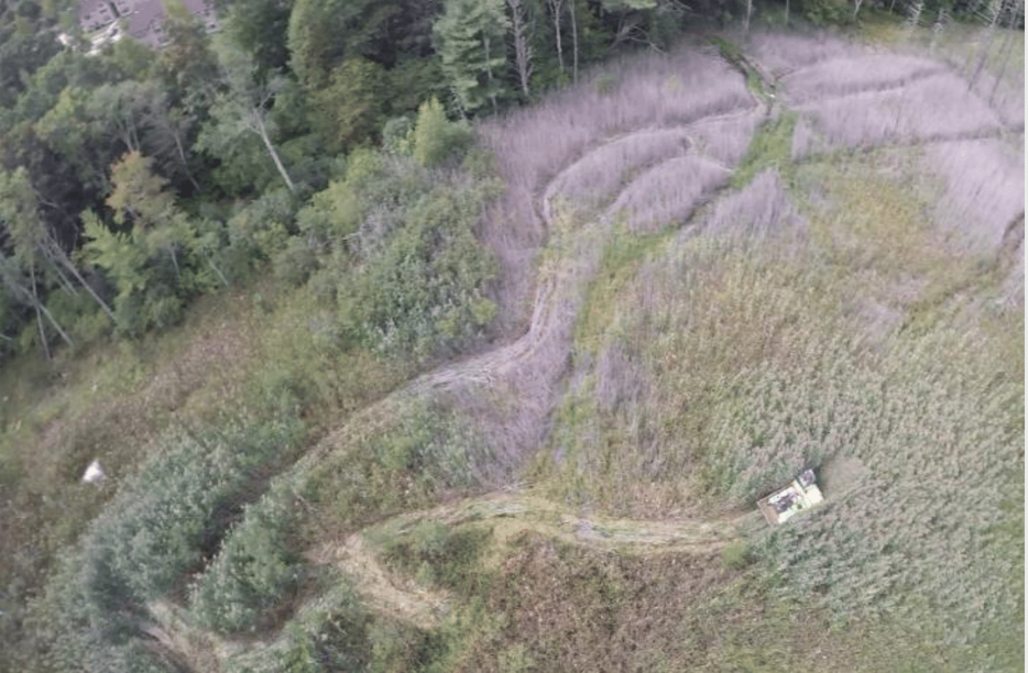
Even after ten years of monitoring and control, invasive species are still receiving extensive management attention. Common Reed and Japanese Stiltgrass are currently the most problematic invaders. They either form dense monocultures, which crowd out native species, or intersperse with native vegetation in isolated patches, which can be difficult to locate and treat without inadvertently impacting native vegetation. Japanese Stiltgrass is more problematic in the mitigation wetlands, and tends to intermix with other wetland plants. However, Common Reed is so prolific in some areas of the wetlands just north and west of the mitigation wetlands (Wetland C) that M&A has used a low impact, tracked vehicle to venture into the larger stands to apply herbicide with power sprayers (see Figure 7). The proximity of the Common Reed stands and the aggressive nature of invasives threaten the diverse plant communities of the mitigation wetlands, which is why continued monitoring and treatment of invasives will be imperative for long-term management of the site.
Highly variable weather periods post-construction appeared to affect the development of the mitigated wetlands during the first few years post-construction. The mitigation wetlands at higher elevations initially developed slower in response to dry periods post-construction; to the point where it was uncertain if areal compensation would be achieved.
Herbivory of planted shrubs and trees by deer and small mammals was especially problematic in the first few years post-construction. The development of scrub-shrub and forested wetlands, which have certain shrub/tree height and density characteristics, was delayed until adaptive management measures, like replantings and herbivore deterrents, were put in place. Because of this herbivory, the shrub/tree density ACOE Success Standard was not met in all scrub-shrub and forested swamp wetlands.
Socio-Economic & Community Outcomes Achieved
Economic vitality and local livelihoods:
The HEEP has provided and is expected to continue to provide many monitoring, educational, and research opportunities for UConn undergraduates, graduate students, and faculty.
Provision of basic necessities such as food, water, timber, fiber, fuel, etc.:
Leachate and contaminated sediment remediation measures have improved the quality of the surface water and groundwater discharged from the wetlands, which eventually reaches domestic wells and other drinking water sources.
Cultural dimensions such as recreational, aesthetic and/or spiritual:
The Hillside Environmental Education Park (HEEP) is a 65-acre conservation area that includes the mitigated wetlands and open space to the north and northwest. An official conservation agreement with CTDEP was formulated, granting long-term protection of the land and its responsible recreational and educational use. Walking trails, boardwalks and observation platforms, and educational signage were erected in the park for recreational and educational use by the local and UConn communities. In addition, UConn natural resource classes use the HEEP as an educational resource.
Regulation of climate, floods, disease, erosion, water quality, etc.:
The landfill closure and remedial actions have improved groundwater quality and increased the safety of drinking water originating from domestic wells near the former landfill, which was a primary concern among local community members.
Has the project had any negative consequences for surrounding communities or given rise to new socio-economic or political challenges?:
N/A
Key Lessons Learned
Thorough yearly monitoring of the mitigation wetlands post-construction and associated adaptive management were integral, and will continue to be integral, to the long-term success of this project.
Extensive hydrologic monitoring was important since precipitation can be highly variable from year to year. Periods of drought following construction resulted in slower wetland development in some wetland creation areas. M&A took precipitation variability into consideration before deciding to take adaptive management actions in case slower wetland development was merely a symptom of reduced precipitation and not impaired overall hydrologic function. Unnecessary management could have had negative effects on the development of the mitigation wetlands. In cases where wetland or vernal pool hydrology was indeed impaired, adaptive management strategies like minor corrective grading (ex. excavating or filling pools) and intermittent stream excavation (to drain certain areas and achieve certain hydroperiods) were utilized.
In response to deer and small mammal herbivory of planted shrubs and trees, M&A tried several herbivore deterrent methods, including: garlic sticks, deer repellent, small wire fence enclosures, and tree tubes. Small wire fence enclosures and tree tubes were the most effective methods. M&A also carried out supplemental tree and shrub plantings in the areas most heavily impacted by the herbivory.
Although using locally sourced soil amendments was a cost-effective strategy, M&A recommends conducting germination tests on the soil. It’s possible that some of the weeds and invasive species present in the mitigation wetlands, which in some cases required extensive control and supplemental planting effort, originated from the soil amendments.
M&A also recommends checking the quality of the seed mixes sold by nurseries. The seed mix M&A used had high upland weed content (especially clovers, Trifolium spp.) that could have influenced wetland plant establishment and in some cases required supplemental plantings. It is also important to make sure that plant material is not mislabeled. M&A discovered that around 20 shrubs labeled as native Speckled Alder (Alnus incana) were actually the very similar-looking, but invasive, European Alder (Alnus glutinosa). The European Alder were promptly located, cut down, and herbicide was applied directly to the cut stumps.
M&A also found that designing the mitigation wetlands with high habitat diversity was extremely effective at promoting wildlife habitat. Effective methods included mound and pool topography and the many aforementioned special habitat features.
Long-Term Management
An official long-term management plan is still being drafted and is set to be finalized in 2018. Long term management of the wetland restoration falls within the overall long term management of the HEEP. The Conservation Agreement (CA) requires preservation of the wetland mitigation areas within the HEEP (including the restoration and creation sites, designated open space, trails, boardwalks and observation platforms) “in perpetuity”. The HEEP CA requires that access be available to the public and that education, recreation and habitat conservation functions be preserved (among others). UConn’s Office of Environmental Policy and the UConn Forester have key stewardship roles in long term management of the HEEP. CTDEEP, the Town of Mansfield, and the public users of the HEEP are also important stakeholders. UConn plans to continue an adaptive management approach to address changing priorities. To fulfill its stewardship role, UConn envisions yearly monitoring and invasive species control, with periodic updates to the management plan. Monitoring of vegetation, water levels, wildlife use, and trail features is expected. Forest management is expected to include selective cutting. Promotion of successional habitats for biodiversity and education is likely to be continued using various methods. Long term management archival curation of data related to wetland restoration is anticipated to continue.
Sources and Amounts of Funding
Funding Source: University of Connecticut
Remediation + Wetland Mitigation = ~$12 million
Wetland Mitigation = ~$1.5 million
Planning, permitting, design, monitoring, and invasive species control related to wetland mitigation = additional ~$0.5 – 1 million
Other Resources
Link to the Landfill Remediation Project Reports:
https://reports.uconn.edu/landfill-remediation-project/
Link to the website of UConn’s Office of Environmental Policy:
https://envpolicy.uconn.edu
Hillside Environmental Education Park (HEEP) Website:
https://ecohusky.uconn.edu/hillside-environmental-education-park/
Related Research
UConn students and faculty are conducting research in the mitigated wetlands and throughout the HEEP on topics such as invasive species management, wildlife management and habitat enhancement, wetland mitigation, and vernal pool creation and management, among others.Primary Contact
Name:
Christopher O. Mason, PWS, President
Affiliation:
Mason and Associates, Inc.
City:
North Scituate
State:
Rhode Island
Organizational Contact
Name:
Richard Milller, Director; Paul Ferri, Project Manager
Affiliation:
UCONN Office of Environmental Policy
City:
Storrs
State:
Connecticut
Email:
[email protected]