Overview
The Onrus peatland is dominated by the plant palmiet (Prionium serratum), an endemic plant to Southern Africa and the only species in its family. This unchannelled valley-bottom wetland is 33ha in size and is situated near the coastal town of Hermanus, South Africa (Lat: -34.389527 & Lon: 19.227932. The Onrus wetland is underlain with peat and plays an important role in climate change mitigation. The Onrus catchment is home to the water supply dam of the town of Hermanus. The wetland is situated on the Camphill School’s property- a school for disadvantaged and physically impaired children. The Onrus wetland is upstream of the Onrus estuary – a key nursery ground for fish and recreational activities. A subsurface peat fire has been threathening the wetland since 11 January 2019. After various conventional fire fighting methods; an innovative technique is currently being implemented to extinguish the subsurface fire – with great success. The wetland will be assessed post fire to determine the extent of rehabilitation interventions required to restore functionality to the wetland and protect the intact and undisturbed section of wetland.
Quick Facts
Geographic Region:
Africa
Country or Territory:
South Africa
Biome:
Freshwater, Coastal/Marine
Ecosystem:
Freshwater Wetlands
Area being restored:
33 hectares
Project Lead:
Departmetn of Environmental Affairs with Overstrand Municipality playing a part in coordination
Organization Type:
Governmental Body
Project Partners:
Overstrand Municipality (a key Partner in coordinating efforts to date)
Working on Fire : Department of Environmental Affairs Natural Resource Management (DEA-NRM)
Working for Wetlands : Department of Environmental Affairs Natural Resource Management (DEA-NRM)
Enviro Wildfire Services (Private)
Hamilton Russell (Landowner)
Camphill School (Landowner)
Project Stage:
Planning / Design
Start Date:
4 March 2019
End Date:
not determined yet
Primary Causes of Degradation
Agriculture & Livestock, Dams & Hydrology, Fire & Weather Events, Invasive Species (native or non-native pests, pathogens or plants)Degradation Description
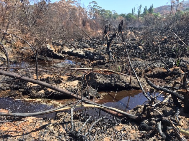
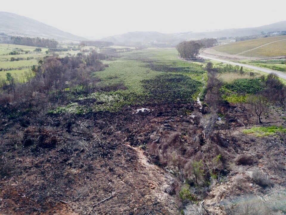
The Western Cape experienced one of its worst droughts in decades. The drought had a significant impact on water levels across the Province. The Onrus wetland is situated below the main water supply dam of the town of Hermanus. The wetland is also largely affected by mature stands of Blue gum trees, invasive to South Africa. Historical flow impediments along with the impact of alien invasive species resulted in dried out peat and a head cut migrating upstream into the wetland. It is also apparent that previous fires have occurred in the wetland. On 11 January 2019 a fire swept through the Onrus wetland. The dry conditions and blue gum debris on the floor of the wetland created the perfect environment for a sub-surface fire to take alight.
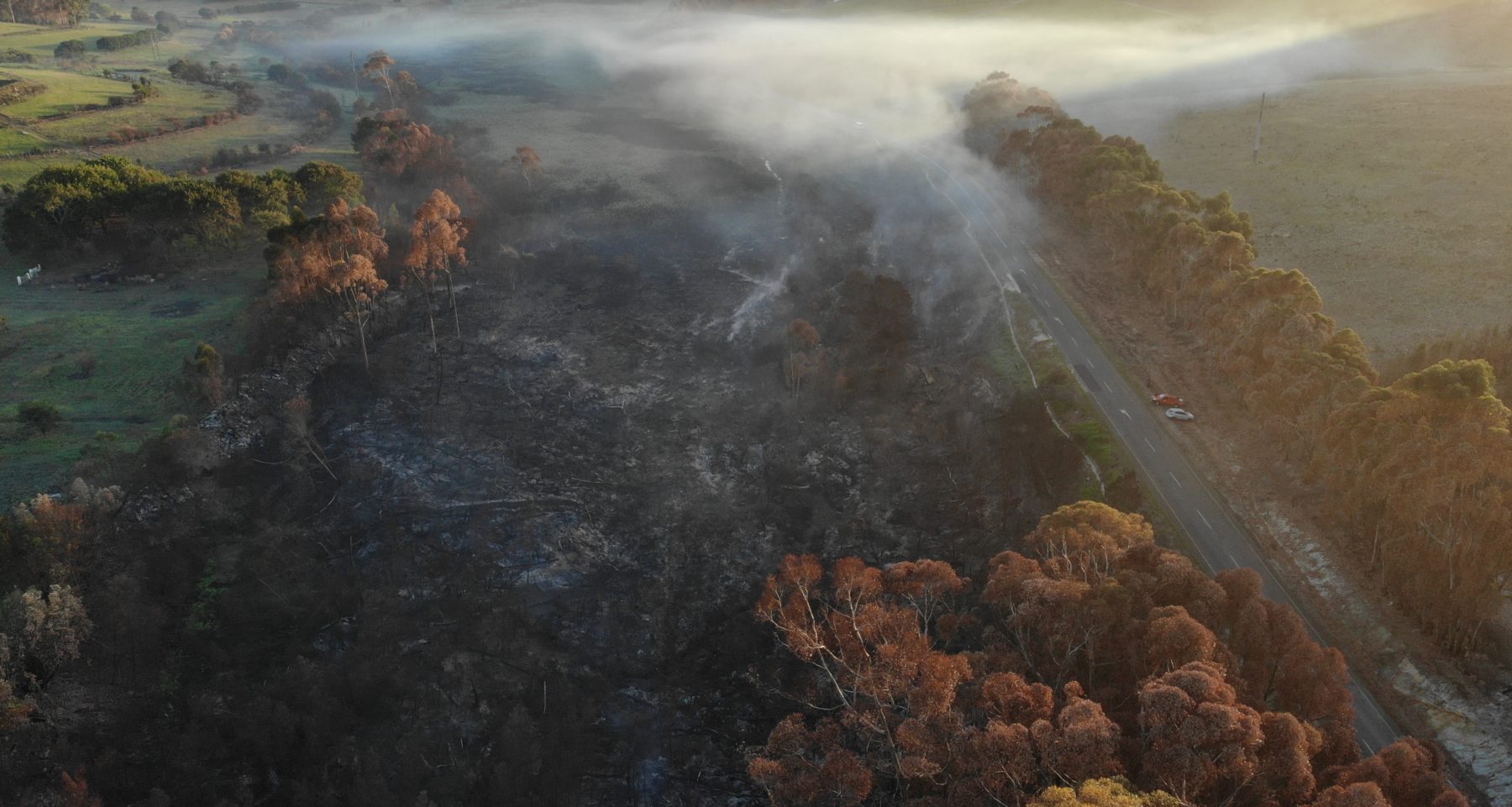
The Peat have been burning subsurface since 11 January 2019. The fire is hazard to the neighbouring Camphill School. Children have been evacuated from the grounds and moved to safer location in the town of Hermanus as there has been respiratory conditions reported – especially in the early hours of the mornings. Aside from the school being affected; the wetland is also a recreational corridor for cyclists and hikers making it dangerous for them to pass through. Furthermore the public road on the Eastern boundary of the wetland is under threat of collapsing. Previous fires have already led to maintenance work being carried out on the road.
The unburned wetland (24 ha in extent) had the following characteristics during the assessments: a. the vegetation was dominated by palmiet.b. Wetland soils were dominated by peat of up to 7.25 m. The upper peat profile was palmiet peat with the lower part (2.5 to 7.25 m) dominated by sedge-radicell peat. Sand was located at the bottom of the peat profile except towards the centre of the basin where the peat profile was deeper than the available sampling extensions. C. A 1 to 2m wide furrow was evident in this section feeding into the active head cut in this unburnt section dominated by palmiet.d. Low water levels were noted in the furrow with the levels 20 to 40 cm below the peat surface in the palmiet.e. Two diversion furrows were noted, feeding water across the width of the peatland and maintaining relatively high levels of inundation at the burning front (Figure 5).5. Therefore, having considered the abovementioned factors it is concluded that. This is a palmiet peatland in an unchannelled valley bottom HGM setting. It contains peat of more than 7.25 m thick, dominated by a lower thick sedge layer with a basal sand and not bedrock layer. This palmiet peatland is therefore unlike other palmiet systems and. The wetland is under severe threat of further degradation as it has been drained, eroded, the peat desiccated, and burned with AIP’s colonising degraded parts. As soon as the subsurface fires are extinguished the wetland should be rehabilitated to prevent further erosion and re-wet the peatland, under the supervision of a competent authority.
Note: Due to the drought the release of large volumes of water from the upstream dam was not an option. Alternative solutions had to be identified in the feat to stop the raging fire.
Defining the Reference Ecosystem
The reference ecosystem is based on diverse sources of information (e.g. multiple extant reference sites, field indicators, historical records, predictive data).Reference Ecosystem Description
This will be done in detail once full scope of Rehabilitation planning is in force.
Project Goals
- Short term goal:
- Extinguish the fire under the constraint of not having large volumes of water available due to the continued drought within the Western Cape.
- Source and Allocate funding towards detailed wetland rehabilitation planning (post fire).
- Medium term
- Awareness and Custodianship by local community and users.
- Source funding for implementation of the Wetland Rehabilitation plan for the Onrus wetland system.
- Initiate implementation of the Rehabilitation plan eg. Stabilise head cut with a structural intervention to stop further erosion upstream into the intact wetland
- Clear and manage invasive tree species
- Long term
- Maintenance and monitoring of wetland rehabilitation
- Re-wetting and
- Landscaping to allow for natural vegetation to return and soil structure to be returned to the area affected by the fire
- Restore functionality of the wetland.
Monitoring
Monitoring Details:
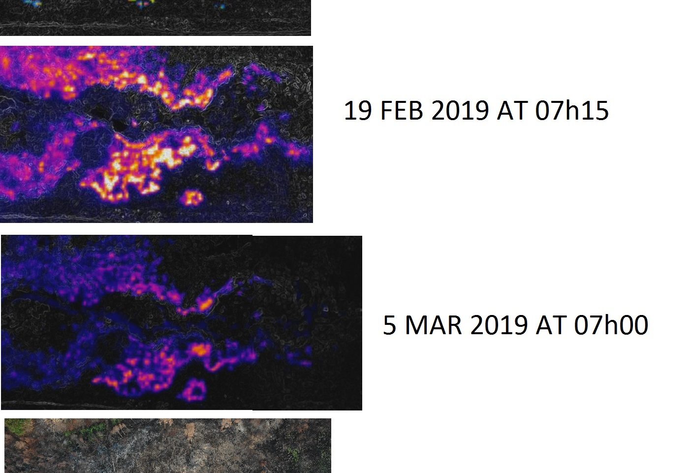
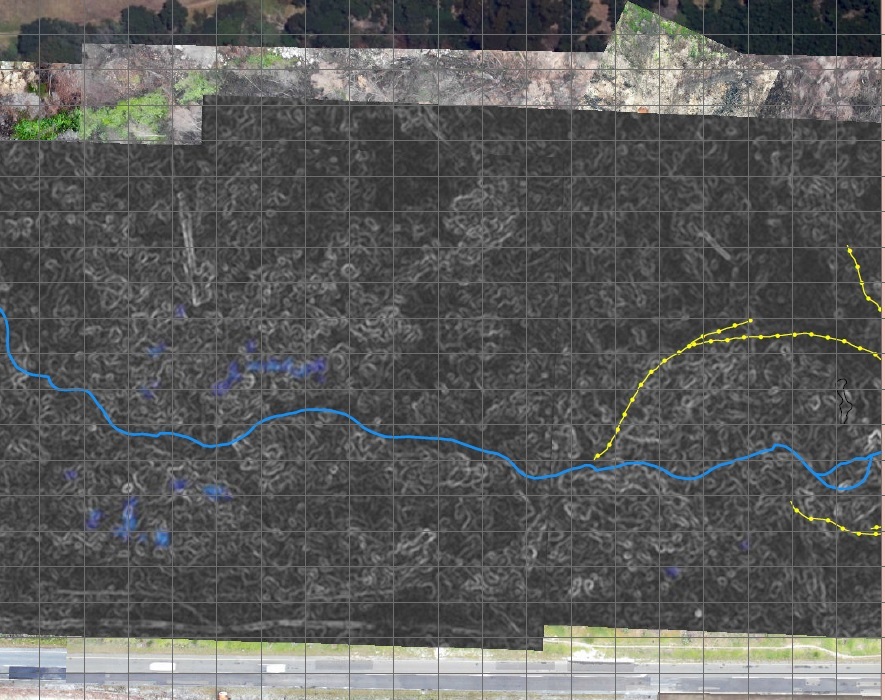
No formal monitoring plan is in place although FLIR (Forward Looking Infrared) imagery has been taken with a drone before firefighting activities commenced to determine hot spots within the wetland. The monitoring is continued during the fire fighting intervention to monitor success of the firefighting phase of the project. The FLIR imagery assisted to plan the fire fighting intervention as the wetland is not safe to walk through while burning subsurface.
Furthermore should funding be awarded a WET-Health assessment will be completed before further rehabilitation work. WET-Health describes the wetland condition based on hydrology, geomorphology and vegetation. The data will be used to measure the success of rehabilitation activities implemented.
Start date, including baseline data collection:
FLIR data was taken by Enviro Wildfire Services at their own expense approximately two months after the fire started to burn.
End Date:
FLIR data will continue until the fire has been extinguished 100% WET-Health monitoring and other associated monitoring will be set up at coordinated intervals pre and post rehabilitation.
Stakeholders
Overstrand Municipality Coordinated efforts to extinguish the subsurface fire and supports further rehabilitation
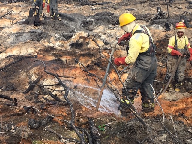
Working on Fire Programme: Deployed a team of 20 fire fighters to extinguish the subsurface fire by using a newly developed method for peat fires. A spike tool with multiple nozzles that is pushed into the soil and pushes water subsurface to roughly 1.5m. It is estimated that the fire should be extinguished completely by the second week of June 2019.
Working for Wetlands Programme: Conducted the initial assessments of the wetland and problem assessment. Made recommendations and will assess the wetland after the fire has been extinguished to determine the extent of rehabilitation required for wetland function to be maintained upstream as well as what to be done in the area affected by the fire. The Working for Wetlands Programme has already scheduled the initial phase but requires funding to assist with a complete rehabilitation plan and
Eviro Wildfire fighting service provider. Enviro Wildfire Services have been using a drone fitted with an infrared camera and self-funded the monitoring activity whilst sharing the imagery to be used in assessing the extent and intensity of the subsurface peat fire. This technology has not been applied on subsurface fires within South Africa before. It has been invaluable use to plan the fire fighting activities and monitor progress accordingly.
Landowners
How this project eliminated existing threats to the ecosystem:
The immediate threat to the Onrus wetland is the subsurface fire hence this will be the immediate threat: Extinguish subsurface fire – in process
Future: Removal and management of woody alien invasive species.
Stabilise erosion and head cut migrating upstream into the intact peat wetland.
How this project reinstated appropriate physical conditions (e.g. hydrology, substrate)",:
Future: Structural intervention required to stop head cut from upstream into intact wetland. Smaller intervention in degraded wetland to lift water table
Landscaping to allow for soil structure to return and retain moisture (currently soils are very hydrophobic.
3) achieve a desirable species composition
Will be determined during post fire Wetland assessment and detailed rehabilitation planning
How this project achieved a desirable species composition:
Will be determined during post fire Wetland assessment and detailed rehabilitation planning
How this project reinstated structural diversity (e.g. strata, faunal food webs, spatial habitat diversity):
Will be determined during post fire Wetland assessment and detailed rehabilitation planning
How this project recovered ecosystem functionality (e.g. nutrient cycling, plant-animal interactions, normal stressors):
Will be determined during post fire Wetland assessment and detailed rehabilitation planning
How this project reestablished external exchanges with the surrounding landscape (e.g. migration, gene flow, hydrology):
Will be determined during post fire Wetland assessment and detailed rehabilitation planning
Activities were undertaken to address any socio-economic aspects of the project:
Will be determined during post fire Wetland assessment and detailed rehabilitation planning
Ecological Outcomes Achieved
Eliminate existing threats to the ecosystem:
Will be determined during post fire Wetland assessment and detailed rehabilitation planning
Reinstate appropriate physical conditions",:
Will be determined during post fire Wetland assessment and detailed rehabilitation planning
Achieve a desirable species composition:
Will be determined during post fire Wetland assessment and detailed rehabilitation planning
Reinstate structural diversity:
Will be determined during post fire Wetland assessment and detailed rehabilitation planning
Recover ecosystem functionality:
Will be determined during post fire Wetland assessment and detailed rehabilitation planning
Reestablish external exchanges with the surrounding landscape:
Will be determined during post fire Wetland assessment and detailed rehabilitation planning
Factors limiting recovery of the ecosystem:
Will be determined during post fire Wetland assessment and detailed rehabilitation planning
Socio-Economic & Community Outcomes Achieved
Key Lessons Learned
Project not completed yet
Long-Term Management
Will be determined during post fire Wetland assessment and detailed rehabilitation planning
Sources and Amounts of Funding
What entities have provided funding and other support for the project? How much has been invested in the project to date? If know, what is the estimated cost per unit restored (e.g. cost per hectare, cost per river mile)?
The Overstrand Municipality played a key role in coordinating initial efforts to assist with problem identification and finding experts to assist in assessing the addressing the problem.
Working for Wetlands assessed the wetland and made recommendations accordingly which led to other stakeholders getting involved.
Enviro Wildfire services contributed by assisting successful planning of fire fighting activities with FLIR data taken at their cost.
Working on Fire deployed a team of 20 fire fighters to the Onrus wetland on 29 April 2019. At the time of this submission the were still on site using the spike tool to extinguish the subsurface fire.
Primary Contact
Name:
Heidi Nieuwoudt
Affiliation:
Department of Environmental Affairs
City:
George
State:
Western Cape