Overview
Beginning in 1988, the local council of Ille et Vilaine, France began restoring coastal dunes in north Brittany that had suffered severe degradation as a result of sand quarrying and heavy tourism following World War II. Sites chosen for restoration were first fenced to prevent further trampling and were then planted with marram grass (Ammophila arenaria) in hopes that original dune morphology and floristic communities would gradually be achieved. A monitoring study conducted 10 years after the project’s commencement showed that the restoration was satisfactory in terms of geomorphology–creating a dune front similar to reference pioneer dunes and a dune summit in the advanced stage of a mobile dune–and that marram grass proved an effective tool for restoring topography. However, the monitoring study also showed that abiotic factors such as salinity and sand accretion played a significant role in determining species richness and composition, and the dunes’ conservation value is yet to be fully restored.
Quick Facts
Project Location:
Ille-et-Vilaine dunes, 48.6676611, -1.9776337000000694
Geographic Region:
Europe
Country or Territory:
France
Biome:
Coastal/Marine
Ecosystem:
Coastal, Dune & Upland
Area being restored:
10.5 hectares
Organization Type:
Community Group
Location
Project Stage:
Implementation
Start Date:
1988-09-03
End Date:
2008-09-03
Primary Causes of Degradation
Mining & Resource Extraction, Urbanization, Transportation & IndustryDegradation Description
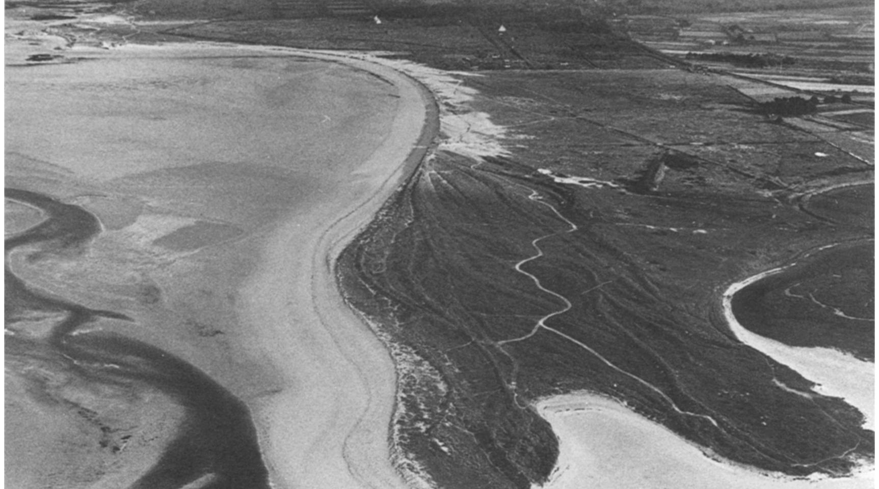
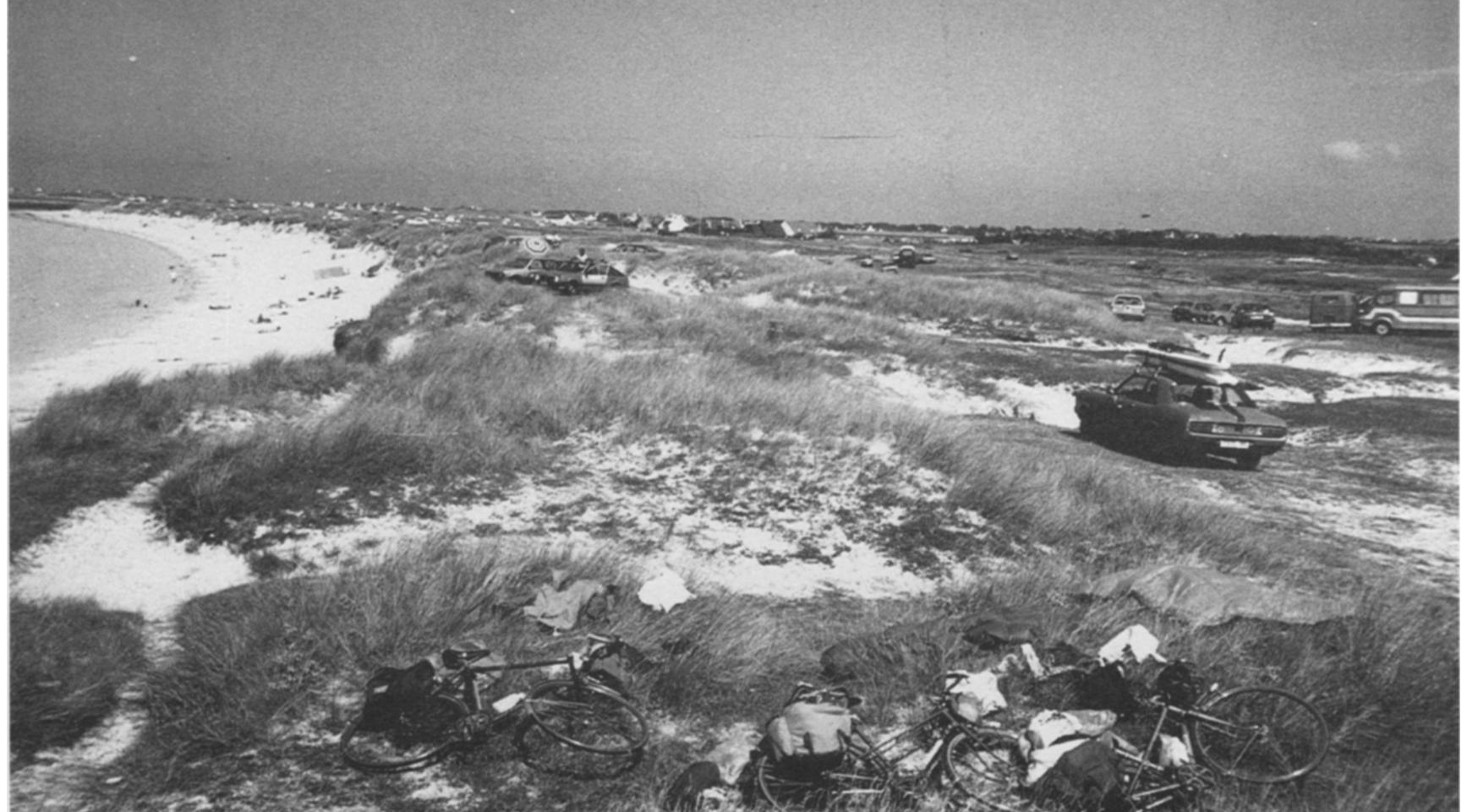
Western France, and particularly Brittany, is a region that has attracted very large numbers of tourists since the Second World War (Guilcher & HallégouÁ«t 1991). The dunes have been greatly disturbed by factors such as sand quarrying and erosion caused by trampling and automobile traffic. In fact, walking, camping, driving, and especially motorcycling have ravaged the dune vegetation and caused remobilization of the sand.
Reference Ecosystem Description
Because the original state of the Ille et Vilaine dunes is not precisely known due to the gradual nature of the degradation, the project’s aims were described in terms of European habitats. The “Mobile pioneer dunes,” adopted in version Eur 15 of the Natura 2000 habitats document (Romao 1996) under code 2110, is equivalent to the association Euphorbio x Agropyretum (Géhu 1994) (association characterized by Euphorbia paralias and Agropyrum junceum or Elymus farctus). It is an open, perennial grassland with E. farctus (Géhu & Tuxen 1975). The “Mobile coastal dunes with Ammophila arenaria,” listed as code 2120 in Romao (1996), is equivalent to the association Euphorbio x Ammophiletum (Géhu 1994) (characterized by E. paralias and Ammophila arenaria). This is a community that colonizes dunes after the pioneer dune stage and that persists with heavy accretion of sand (Géhu 1969). The fixed dunes described under the term of “Northern fixed dunes with a vegetation of Galio-Koelerion albescens, Corynephorion canescentis” (2131) (Romao 1996) belong to the association Hornungio x Tortuletum (Géhu & De Foucault 1978). Also called gray dunes or mossy dunes, they are typified by a carpet of bryophytes dominated by Tortula ruralis ssp. ruraliformis and colonize relatively unstable parts of rear dunes (Géhu & De Foucault 1978).
Project Goals
The aim of the restoration was to recreate the dune topography and facilitate the return to a landscape with all characteristics of an undisturbed ecosystem (including a pioneer dune, a mobile dune, and a stabilized dune with their associated plant communities).
Monitoring
The project does not have a monitoring plan.
Description of Project Activities:
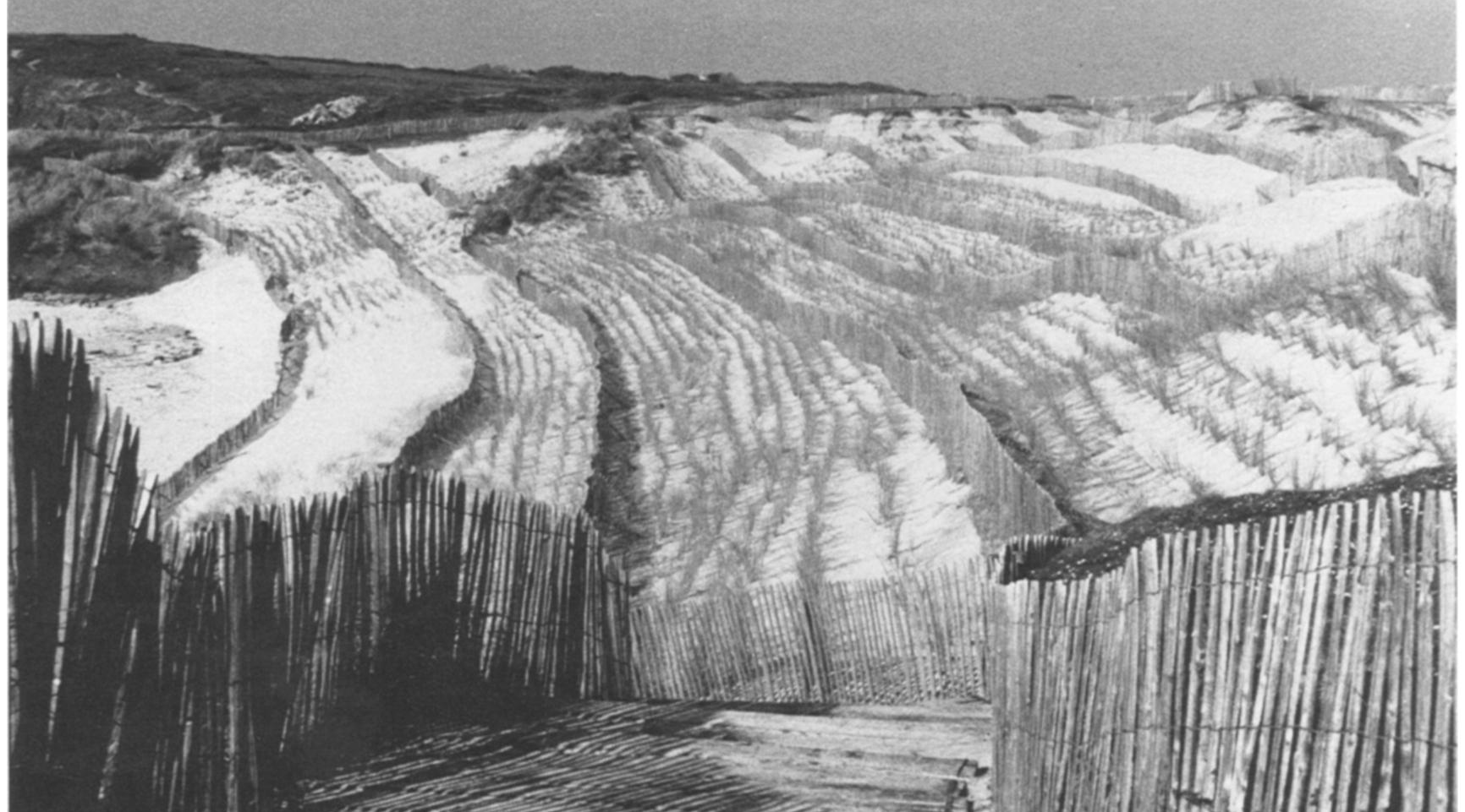
A restoration program has been implemented on the Les Chevrets, L'anse Du Guesclin and Le Verger dunes since 1988. Wooden fences have been installed, and marram grass (Ammophila arenaria) has been planted using standard methods (Jacamon 1975; Despeyrou 1984; Boucheron 1987; Klomp 1989; Van der Maarel 1997). In some cases, initial landscaping was conducted (Duffaud 1998). The dune morphology and the vegetation were monitored from 1989.
After installing picket fencing around the whole of each dune system without soil preparation, the enclosures were immediately planted with marram grass over their entire area. The plants were kept in place and planted during the management day (April 1988) without other treatments.
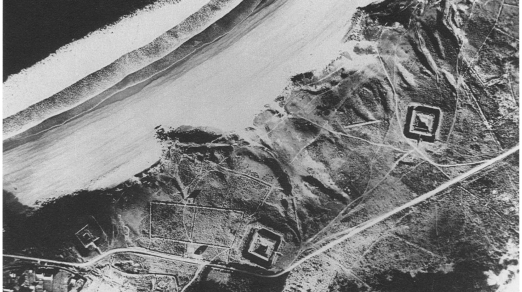
The Les Chevrets dune, with an area of about 4 ha, had been heavily degraded before 1988 by a campsite and was re-landscaped before the start of restoration. The L'Anse Du Guesclin dune, also with an area of about 4 ha, is bounded to the rear by a road and had a high visitor pressure. The Le Verger dune has an area of about 2.5 ha and had been subjected to extensive sand quarrying.
At each site, two lines measuring 50m in length were set up from the beach to the rear dune. Three permanent parallel transects were installed at right angles to each of these lines as a function of their topographical position in 1989: one in front of the dune, the second at the summit, and the third in the rear dune. Topographical measurements were made from 1989 to 1998 using a theodolite. These provided information on the accumulation of sand from the beach to the rear dune.
Every year in June, the vegetation was surveyed using the permanent transect method (Daget & Poissonet 1971; Gloaguen & Touffet 1974). This linear method was chosen because it is well suited to the vegetation structure and was more reliable than measurements on quadrats. One hundred permanent points were distributed at 10 cm intervals along these transects, whose ends were marked by posts. The vegetation was recorded as the presence or absence of each species at each point. The frequency of the species in the 100 points provided an estimate of their cover.
Ecological Outcomes Achieved
Eliminate existing threats to the ecosystem:
In terms of the dune topography, the installation of fences and the plantation of marram grass produced the desired results, as they have done elsewhere (Jacamon 1975; Despeyrou 1984; Boucheron 1987; Klomp 1989; Van der Maarel 1997). There was a progressive build-up of the topography in the front and at the summit of the dune. The very light sand accumulation in the rear dune significantly differentiated it from the front of the dune from 1992 and from the dune summit from 1993. The front of dune and the summit of dune became distinct in terms of sand accumulation from 1993, this being greater at the front of the dune than at the summit. This amounted to 2m in 9 years and could, in time, have formed a new dune ridge in front of the initial summit.
In addition to the geomorphological structuring of the landscape, the front of the dune, the dune summit, and the rear dune were distinguished by their plant composition and species richness. Analysis of the plant cover was unable to discriminate between the landscape units over the 10 years. The overall cover of the dune increased from 1989 and then reached a stable level, varying around 75%. The species richness was, however, distinguished between the landscape units from 1992, with the exception of 1997. The rear dune was clearly distinguished. The front of the dune, the poorest zone, was clearly distinguished from the rear dune. The dune summit was significantly different from the rear dune from 1992 to 1996 and had an intermediate species richness between the front and the rear dune from 1998.
The Front of the Dune -- The plant community at the front of the dune was dominated by two perennial grasses: Elymus farctus and Ammophila arenaria. After 10 years, E. farctus became dominant, despite a brief decline in 1998, and the community became similar to the pioneer dune described by Géhu and Tuxen (1975). Among the seven species encountered, five are listed in the surveys of the pioneer dunes by Géhu and Tuxen (1975). Leontodon taraxacoides is associated with fixed dunes (Géhu & De Foucault 1978), and Conyza canadensis is a ruderal that does not belong to the dune assemblage.
The Dune Summit -- Ammophila arenaria dominated the dune summit. Its cover increased until 1995 and then stabilized at about 60%. Elymus farctus increased in the early stages of restoration but declined from 1993 to 1994. The vegetation became more diverse in the later stages, with the appearance of Festuca arenaria, Calystegia soldanella, and Vulpia membranacea.
Because of the dominance of A. arenaria, this community is very close to that of the mobile dune described by Géhu and Tuxen (1975). Five of the 15 species recorded in 1999 also occurred in the mobile dune association (Géhu & Tuxen 1975), eight others in fixed dunes (Géhu & De Foucault 1978), whereas C. Canadensis and Sonchus oleraceus are ruderals.
The Rear Dune -- The rear dune saw the greatest changes during the 10 years. Ammophila arenaria persisted with a cover of about 20%, but E. farctus declined from 1992. The vegetation became more diverse, and Festuca rubra ssp. arenaria became dominant from 1998. Tortula ruralis ssp. ruraliformis appeared in 1996 and constituted the first component of the cryptogam layer.
Among the 20 species encountered, 13 are listed by Géhu and De Foucault (1978) in fixed dunes, two in pioneer dunes, and the other five species reflect a ruderal tendency. Ammophila arenaria was still present, but the dominance of Festuca rubra ssp. arenaria, accompanied by Ononis repens, V. membranacea, and T. ruralis ssp. ruraliformis, differentiates it from the mobile dune of Géhu and Tuxen (1975). Tortula ruralis ssp. Ruraliformis was present but did not yet form the mossy carpet that characterizes the fixed dune (Géhu & De Foucault 1978).
Factors limiting recovery of the ecosystem:
The variation in species richness and floristic composition from one zone to another can be explained by abiotic factors such as salinity and the accretion of sand. The front of the dune is characterized by strong salinity constraints, indicated by both the dominance of lyme grass and the scarcity of marram grass, a species much less tolerant of salt stress (Boucheron 1987). Marram grass is strongly related to sand accretion (Jungerius & Van der Meulen 1997). Its loss of vigor in the rear dune can be explained by the low rates of sand accumulation that were recorded. In the rear dune the constraints related to being close to the sea and the instability of the soil decrease. Less specialized species appear, and the species richness increases.
Both in terms of diversity and structure, the rear dune remained clearly different from the association defined by Géhu and De Foucault (1978). Tortula ruralis ssp. ruraliformis was present but with a low cover that did not result in the formation of the moss and lichen carpet characteristic of fixed dunes. A species richness of about 13 species in a few square meters was described by Géhu (1997), but species richness did not exceed 11 species on average on project transects. At this part of the dune profile, the floral composition greatly depends on the local context. The occurrence of some nitrophilous plants that do not belong to the reference association reflects the strong human interference in the past. The lack of species typical of fixed dunes can be explained by the depleted seed bank after many years of degradation and isolation from seed sources--that is, intact fixed dunes.
Socio-Economic & Community Outcomes Achieved
Key Lessons Learned
For a long time the aims of dune management were concentrated on fixing moving sand. The proximity of human economic interests made it essential to control large-scale geomorphological phenomena and, especially, the drifting of sand into inland areas. The fixing of dunes is now well controlled, but a new challenge has come to the fore: the conservation of the natural character (Gadgil & Ede 1998). In dune restoration Sabino et al. (1993) distinguished two objectives: the restoration of the dune profile and the restoration of the original vegetation. Monitoring the restoration processes on the dunes of the Ille et Vilaine showed that these two mechanisms are independent. The implementation of restoration measures quickly led to a good plant cover in all the landscape zones. However, the conservation value and diversity only returned slowly, and the rate of return varied from one site to another.
The return to reference ecosystems involves a rehabilitation in which the succession passes through a transitory ecosystem: in this case, a plantation of marram grass. Marram grass provides a quick soil cover and builds up the dune height by trapping sand (Ku¨ hnholtz-Lordat 1923). It is very effective at restoring dune ridges, but it seems to slow the vegetation succession in the rear dune. This phenomenon was reported by Lemauviel (2000) and Lemauviel et al. (2003) in France, by Webb et al. (2000) in Australia, and by Poulson and McClung (1999) in Indiana with the American species, Ammophila breviligulata. The presence of marram grass is undesirable in a semi-fixed or fixed dune, where the preservation of conservation value is paramount. This plant helps maintain instability by trapping sand and by disturbing the soil by the movements of its leaves. Its presence indicates that the soil is not sufficiently stabilized. Marram grass is a good tool for restoring the topography, but it will take a very long time to restore the conservation value of the dune.
Long-Term Management
These restoration procedures resulted in a vegetation cover on what previously had been bare soil and gave a conservation value to protected sites by combating degradation factors and visitor pressure. However, a return to a reference state (sensu Aronson et al. 1993, 1995) has not yet been completed. At the landscape scale the structures and the communities of pioneer dunes and mobile dunes have been restored. On the other hand, at the ecosystem scale, although the pioneer and mobile dunes have been restored, the fixed dune restoration is not complete but is in a correct trajectory toward restoration. Continued monitoring will be needed.
Sources and Amounts of Funding
The project has been conducted by the Ille et Vilaine local council.
Other Resources
Rozé, Franúoise, and Servane Lemauviel, 2004. Sand Dune Restoration in North Brittany, France: A 10-year Monitoring Study. Restoration Ecology 12(1) 29-35.
Guilcher, André, and Bernard HallégouÁ«t, 1991. Coastal Dunes in Brittany and Their Management. Journal of Coastal Research 7(2) 517-533.
Franúoise Rozé
Université de Rennes 1, Equipe “Dynamique des communautés,” U.M.R.
ECOBIO 6553, Complexe scientifique de Beaulieu, 35042 Rennes cedex, France.
email [email protected]