Overview
A forest restoration project is being implemented on a privately owned land in hilly area, at Wan-kusawade, Taluka Patan, District Satara in Maharashtra, India. It is part of hilly region locally known as Sahyadri, the Northern Western Ghat. This area forms catchment of Koyna backwaters, one of the largest hydro-electric projects and adjacent to Koyna wildlife sanctuary.
Being part of Western Ghats, the climatically climax ecosystem is ‘semi-evergreen tropical forests’, with very high rainfall average annual 5,500 mm, average altitude 897 m from MSL. Sahyadri mountain ranges have been popular as land of ‘hill forts’ and have housed very small human population since beginning owing to resource availability, mainly low cultivable land and water sources. These ranges have been abundant in forests and high biological diversity.
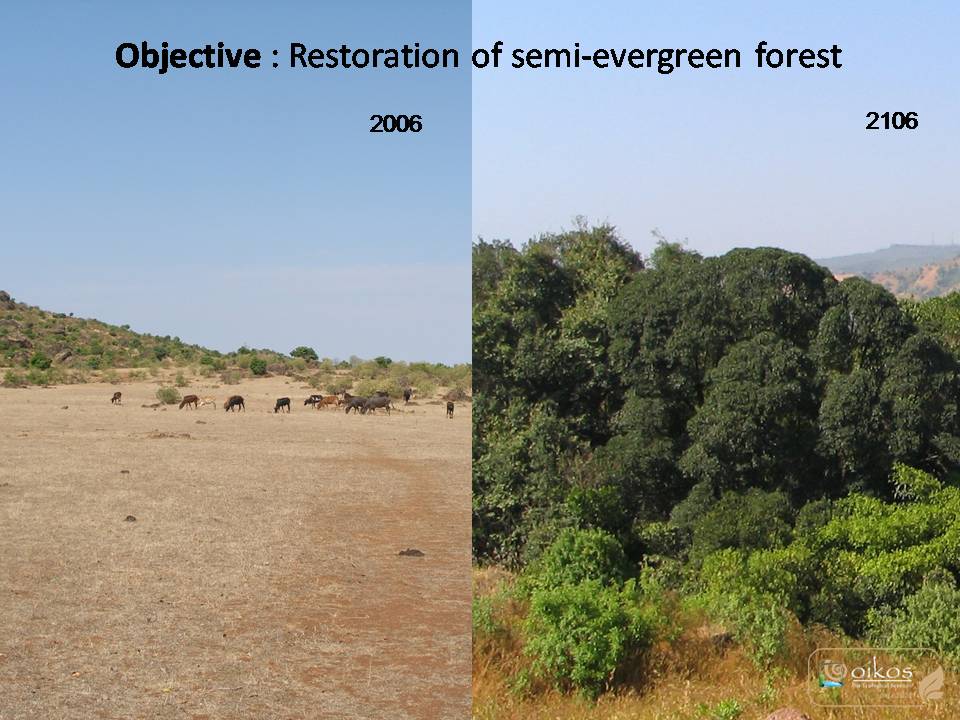
Considering the degraded lands in overall region & project catchment, it was decided to set the goal for land development as ‘Restoration of semi-evergreen forest’ with ‘assisted natural regeneration’ that will strengthen the natural resources and follow ecological succession to become sustainable project in a long run. Now after 15 years, one can see that the natural regenerative capacity of land has improved while building much required resilience in the system.
Quick Facts
Project Location:
Unnamed Road, Kusavade, Maharashtra 415014, India, 17.5218683, 73.8221441, 7, ChIJD52ZFGcYwjsRJt4wBtJkXCg, Unnamed Road, Kusavade, Maharashtra, MH, 415014, India, IN
Geographic Region:
Asia
Country or Territory:
India
Biome:
Tropical Forest
Ecosystem:
Tropical Forest - Moist Broadleaf
Area being restored:
9.6 ha
Project Lead:
OIKOS for ecological services, PUNe
Organization Type:
Consultant / Consulting Company
Project Partners:
1. OIKOS, Pune an eco-consultancy working in the field of eco-management since 2002.
2. Land owners: Atul & Geetanjali Kulkarni, Dheeresh & Snehal Joshi, and the Kulkarni family.
3. Adhiwas Foundation, a public trust, working mainly with research and documentation
Location
Project Stage:
Post-Implementation Maintenance
Start Date:
2005-06
End Date:
2030-12
Primary Causes of Degradation
Agriculture & Livestock, Dams & Hydrology, Deforestation, FragmentationDegradation Description
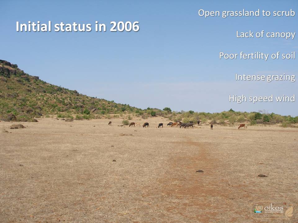
The land and surrounding areas have been under intense human utilization roughly since 1960. As per the socio-ecological setting and local people, during old times, there was a very dense forest in this area with key species like The Indian Gaur or Bison (Bos gaurus), The Bengal tiger ( Panthera tigris tigris). Eventually for various reasons like wood extraction, cultivation, grazing, fuel wood cutting; the forests slowly degraded to present condition of scattered shrubs, scrub & grassy patches. This also initiated soil erosion in form of gullies, loss of soil fertility and soil moisture. This region has been blessed with natural springs on which the local livelihood depends, now with slight decrease in spring discharge volume. With this overall degradation, the streams have lost their riparian vegetation & habitats. So, currently hardly any area is seen under original semi-evergreen forest cover, with some exceptions as government forest and sacred groves protected by the eco-wise tradition by the communities in the name of their local deities.
The local community have been largely agrarian and depended upon the rice cultivation in river valley, shifting cultivation on hill slopes, cattle, NTFP from surrounding forests. It is hard to live in hills with forests and high rainfall due to the limiting factor of availability of year-round water sources. So, the human population of these remote regions that not connected to main economic centers, is very low.
After the Koyna dam construction in 1964, the river valley was submerged, destroying cultivable areas of these hill communities. Some of the villagers then shifted to resettlement areas and some to the higher slopes. This triggered increase in shifting cultivation on slopes and more and more land started becoming open with continual loss of original forest cover.
Defining the Reference Ecosystem
The reference ecosystem is primarily based on contemporary reference sites or existing analogues of the pre-degradation ecosystem.Reference Ecosystem Description
The reference ecosystem is based on diverse sources of information (e.g. multiple extant reference sites, field indicators, historical records, predictive data)
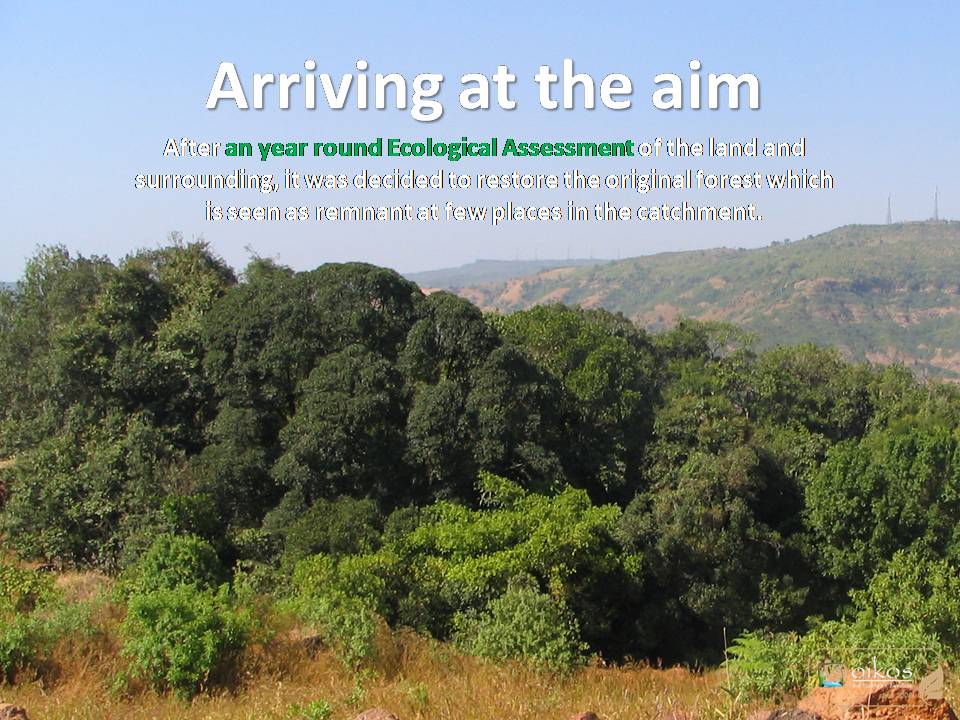
The reference ecosystem of the area is restricted mainly to the government protected wildlife sanctuary, some in-accessible patches of forests and sacred groves protected by the communities. It is semi-evergreen tropical forest with regionally special species of flora. The forest character varies from plateau to slopes depending upon environmental conditions and strata. The biodiversity of such forest ecosystem is well documented by researchers and government departments like Botanical survey of India, Zoological survey of India. This region is dominated by laterite rock and deep lateritic soils.
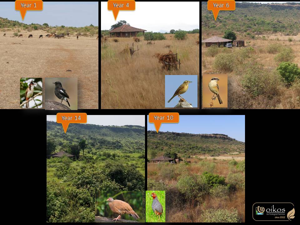
The seral stages in ecological succession from open soil conditions to a forest are clearly seen in the landscape and shows steps by which the ecosystem restoration will progress. There are 4 to 5 key stages in restoration like clump forming grass community, then shrub clusters, then sparse dwarf tree canopy, dense tree canopy and finally the mature semi-evergreen forests. Each stage has specific set of floral community and associated faunal diversity, which act as indicators of restoration progress.
All these seral stages and reference ecosystem areas were studied in detail to understand the process. When project was initiated, main objective was to improve the physical structure by controlling soil erosion, improving organic matter, increasing soil fertility and soil moisture. Focus on plantation is kept to minimum, just to increase the diversity of area specific flora. Otherwise, it is aimed to increase the natural regenerative capacity of land so that process of restoration will happen passively after initial physical work. A thorough understanding of social practices, traditional knowledge of locals, their time-tested techniques helped in planning the restoration activities and techniques. This decreased external inputs required in the effort and also reduced ecological footprint of the work.
A close monitoring of the process and results have helped in changing some activities like period of plantation, fencing options or species selection.
Project Goals
Broad objective of the project is ‘to establish model of eco-restoration in Western ghats for private lands’ along with restoration of near original forest cover on land. It will benefit local landscape by providing a safe habitat for small fauna, collection of local plants, reduction in soil erosion and soil temperatures and a carbon sink. Categorical use of local, low cost techniques will make them easily replicable locally while being a showcase for conservation and restoration. Local community also will get benefitted by providing employment at village level.
Monitoring
Monitoring Details:
Regular visits for documentation, result monitoring & troubleshooting or changes to restoration activities.
Stakeholders
The land being owned by city dwellers, they are the main stakeholders in this project apart from natural elements for which the effort is being taken. The owners have been actively involved in the entire process write from basic eco-assessment. The goal setting and entire planning was done with their inputs and they have strongly supported throughout implementation process. Their vision to give back to nature is the main driving force behind this work and their active involvement in spreading the word about achievements is greatly appreciated by society. Together with the implementing agency, they have been involved in awareness creation about eco-restoration as a tool to achieve conservation of nature.
The owners visualize this land to be dedicated for the cause of conservation perpetually and strive to make the necessary arrangements to maintain the land use as forest, not to be converted to any other anthropocentric land-use. The project has gained good publicity through various outreach events like talks, online sessions, field visits, articles in newspapers.
How this project eliminated existing threats to the ecosystem:
The purchase of land from local villagers to urban owners changed the land use from cultivation & resource extraction to conservation. And then protection from all negative human activities was done through a thorn fence combined with live hedge.
How this project reinstated appropriate physical conditions (e.g. hydrology, substrate)",:
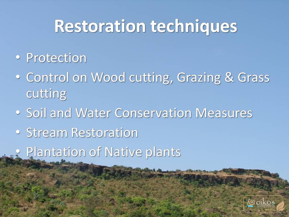
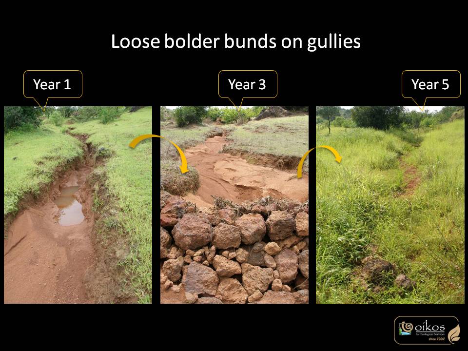
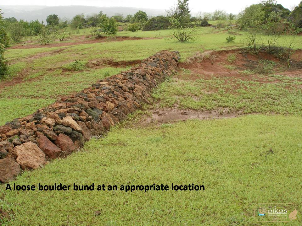
Stream restoration through appropriate stone structures, plantations was initiated in first phase of physical work. Then site specific measures to control soil erosion, gully formation, sheet flow, were installed. Both these measures used local stone and local people. Thirdly to restore soil structure, mulching of local grass cover was aided with protection to vegetation & biomass from grazing & fire.
How this project achieved a desirable species composition:
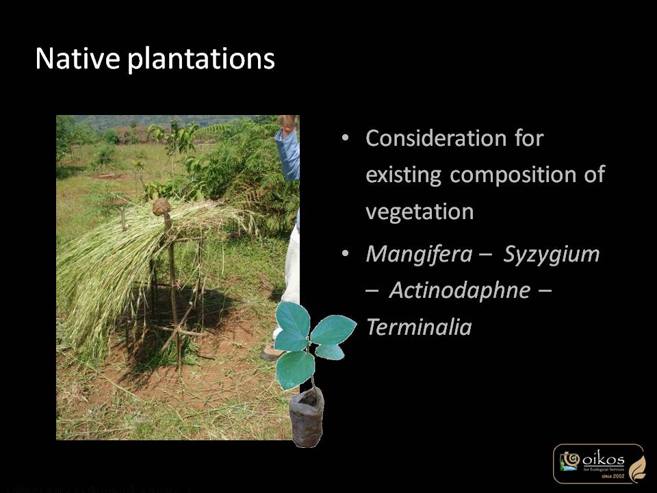
Plantation of local forest trees with specific percentage as seen in reference forest patches, has been a focus since beginning. This has helped in introducing correct species at correct locations that will finally form the higher canopy. Apart from this, the focus is on natural regeneration that goes hand-in-hand with soil structure improvement and changing soil conditions.
How this project reinstated structural diversity (e.g. strata, faunal food webs, spatial habitat diversity):
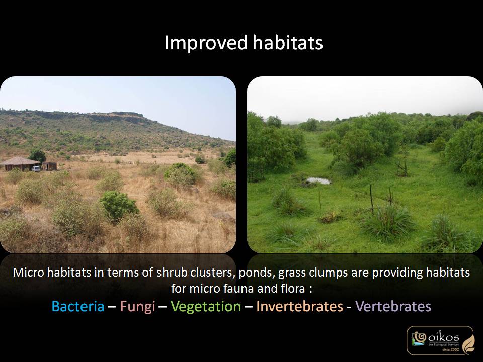
The land has deep, fine soil cover that has been a focus for quality improvement which can be seen in indicator species. Central policy was to arrest soil erosion and addition of local biomass. So as the restoration work progresses faunal chains will get established. The topography and small land features when protected becomes various microhabitats. Some small habitats like ponds, brush piles, mounds were categorically planned to increase the habitat diversity.
How this project recovered ecosystem functionality (e.g. nutrient cycling, plant-animal interactions, normal stressors):
Protection to vegetation, and letting nature’s process take place was the main strategy that have worked well.
How this project reestablished external exchanges with the surrounding landscape (e.g. migration, gene flow, hydrology):
The land is a small functioning unit of entire landscape. To keep it as is, hard boundaries were avoided, diversion of streams was never planned but streams are restored so as to retain the connection. Gully formation is controlled for soil erosion control.
Activities were undertaken to address any socio-economic aspects of the project:
Involvement of local villagers in various ways has been planned since beginning. Right from employing those for various land works to conducting specific sessions for their awareness creation have been undertaken. This helps connecting them to activities happening on land for conservation. It has helped to certain extent for tackling issues like cattle grazing control, general support of village for the work, etc.
Ecological Outcomes Achieved
Eliminate existing threats to the ecosystem:
Protection by local means have worked well over these years since 2006 and have effectively stopped the threats like cattle grazing, fire, and cutting completely.
Reinstate appropriate physical conditions",:
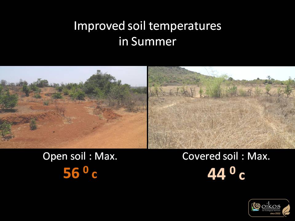
Measures taken to arrest soil, increase it’s fertility and moisture have worked well. This in totality has helped restoring soil, soil moisture and hydrology. The indicators are seen in biodiversity, water flows and soil properties. Even the soil organic carbon shows a positive trend across various habitats than the control sample.
Achieve a desirable species composition:
Since this is an ongoing process, project is yet to achieve the final ecosystem structure and will take long time. But existing species composition is indicating the present seral stage of dense shrubbery which is the desirable output at this point in time. Local composition of shrub clusters is now present with seasonal diversity.
Reinstate structural diversity:
There is steady change in indicator species groups from open conditions to dense shrubbery. Presence of key faunal species like insectivorous reptiles, birds indicate increase in insect species & numbers, establishing initial food chains. More complex food chains & webs will get strengthened as the years progress. A variety of micro habitats all over the land attract diversity of species.
Recover ecosystem functionality:
The mulching of biomass grown naturally during monsoon has helped in restoring nutrient cycling. This has also shown that natural processes have been established that increase the plant diversity, retains whole life cycle of all plant species, offering various associations like butterfly host plants.
Reestablish external exchanges with the surrounding landscape:
Considering that the area of project is very small for the immediate landscape of the village catchment, very few exchanges are possible. One of them is reinforcement of local hydrological structure. The streams passing through land are well protected and do not initiate soil erosion. Also, some specific faunal species are seen just on project land otherwise absent in immediate surrounding. Gully plugging & vegetation growth have reduced soil erosion.
Factors limiting recovery of the ecosystem:
Continuous maintenance of dry thorn fence is required that keeps grazing cattle outside. Fire is another limiting factor in restoration here, so yearly work of making fireline is much needed to protect from fire in dry season. As the fire is induced by locals, it is necessary to keep a continuous dialogue with them for more awareness creation.
Socio-Economic & Community Outcomes Achieved
Economic vitality and local livelihoods:
As a policy, we have always preferred involving local individuals in restoration work that generates some income for them. This land of 24 acres supports one family completely and owners have also come forward to support the education of children of the family.
Provision of basic necessities such as food, water, timber, fiber, fuel, etc.:
Work on land has ensured recharging of borewell that is the sole source of water for the land. Production of good quality fodder from the land is extracted by the caretaker for his cattle, so supplying it’s yearly need of fodder. But apart from this, it is not allowed to extract anything at this point since it is vital source for restoring land processes. Eventually once the ecosystem is fully restored, controlled extraction might be allowed.
Cultural dimensions such as recreational, aesthetic and/or spiritual:
The land owners completely enjoy the process and learn through the progress. A restoring land looks different than outside with more cover & greenery, and functionality which is appreciated by locals, owners & visitors.
Regulation of climate, floods, disease, erosion, water quality, etc.:
Soil erosion from this land has completely stopped now, so it doesn’t contribute to siltation of Koyna dam. Even the water flowing through is crystal clear even in high intensity monsoon as compared to adjacent lands, which is a great achievement. Lowering of soil temperatures locally means this land is not adding to global temperature rise. It is also acting as a carbon sink. All this work has improved the micro-climate to great extent.
Has the project had any negative consequences for surrounding communities or given rise to new socio-economic or political challenges?:
There is one apprehension in local people’s mind that this work will attract more wild animals like wild boar, leopard or bear and increase human-wildlife conflict. This could be a potential threat to their agriculture or cattle. Otherwise, they appreciate the efforts of planting various species and increase in fodder availability.
Key Lessons Learned
This process of restoration have been a learning curve for the team, testing patience of owners at all times in understanding the slower rate of nature reestablishment, and why ecological restoration is a better approach than plantations for landscape level restoration. Continuous documentation of the process has also helped in understanding natural succession, entry-exit of species, indicators of various stages, etc. It helped in changing the strategies planned in first year like species selection, use of local materials or addition of nutrients, etc.
It also triggered a thought process for handling deliberate negative actions by anti-social elements, like fire and tested the resilience of land that is in place due to this slow successional restoration.
The data gathered so far can substantiate many research subjects and provide insights to ecological succession.
Long-Term Management
Current status of project is post-implementation maintenance and monitoring. After understanding the long-term requirements of such restoration projects, the owners and consultants have jointly worked out a plan to safeguard the land and restoration work. The plan is, handing over the land to a trust so that it can form a field station for experiments in restoration, education and research. This could be most effective way apart from keeping the land-use unchanged. With this, various funding sources like CSR, individuals, research funds can be explored for future actions.
Sources and Amounts of Funding
Since beginning of project, the land owners have taken complete responsibility of funding every stage of project, i.e. planning, implementation and monitoring. Till March 2021, the total amount invested is in order of INR 25,00,000 /- towards all implementation activities by owners. Average cost per hectare per year comes out to be INR 9,500 /- for restoration work done till March 2021.
Above this, the team of consultant has invested their time, & expertise in documentation, research and awareness creation.
Other Resources
Check project Ranwa on https://oikos.in/html/project-turn-key.html
Primary Contact
Name:
Manasi Karandikar
Affiliation:
Founder and Managing Partner at OIKOS for ecological services
Organizational Contact
Email:
[email protected]