Overview
Burns Bog is a 3,000 ha raised bog located in southwest British Columbia, Canada. Beginning in the 1930s, the bog underwent 50 years of industrial peat extraction, resulting in an extensive network of drainage ditches that lowered the water table and allowed the establishment of trees and other non-bog plant species. Much of the original margin of the bog has been converted to other land uses, such as industrial operations and agriculture. In 2004, Burns Bog was purchased by four levels of government for ecological conservation and is being actively restored with ditch blocking. Long-term monitoring since 2005 has shown a gradual increase or stabilizing of the water table across most of the bog. The edges of the bog continue to be drained by ditches adjacent to farms; restoration efforts are now being focused on these areas. Invasive species are being actively managed, and experimental tree removal is taking place. Greenhouse gas fluxes are being monitored to assess the ability of the bog to sequester carbon in the long term. In 2013, Burns Bog was designated as a Ramsar Wetland of International Importance.
Quick Facts
Project Location:
Burns Bog, Delta, BC, Canada, 49.1436662, -122.92976820000001
Geographic Region:
North America
Country or Territory:
Canada
Biome:
Temperate Forest
Ecosystem:
Freshwater Wetlands
Area being restored:
3000 ha
Project Lead:
City of Delta
Organization Type:
Governmental Body
Project Partners:
City of Delta
Metro Vancouver Regional Parks
British Columbia Ministry of Environment & Climate Change Strategy
Environment and Climate Change Canada
University of British Columbia
University of Victoria
Simon Fraser University
Royal Roads University
British Columbia Institute of Technology
Location
Project Stage:
Implementation
Start Date:
2001-01
End Date:
ongoing
Primary Causes of Degradation
Invasive Species (native or non-native pests, pathogens or plants), Mining & Resource ExtractionDegradation Description
Peat was extracted from Burns Bog during the 1930s-1980s. The operation involved the installation of an extensive network of drainage ditches, as well as removal of vegetation and peat across the majority of the bog. The drainage ditches resulted in a lowering of the water table in the bog, leading to the establishment of trees and a reduction in the coverage of Sphagnum mosses. The edges of the bog were converted to other land uses such as agriculture and industrial operations. Although a large-scale ditch blocking program is taking place in the interior of the bog, part of the bog margin remains at risk of drainage due to adjacent farm ditches.
Defining the Reference Ecosystem
The reference ecosystem is based on diverse sources of information (e.g. multiple extant reference sites, field indicators, historical records, predictive data).Reference Ecosystem Description
Based on surveyors’ notes from the late 1800s and 1927, as well as paleoecological studies in the late 1970s, Burns Bog was historically characterized by open heath (including Rhododendron groenlandicum, Vaccinium oxycoccos, Vaccinium uliginosum, Kalmia microphylla spp. occidentalis, Eriophorum chamissonis, Rhynchospora alba, and Gaultheria shallon), Sphagnum mosses, and scrub Pinus contorta var. contorta. About 29% of Burns Bog that was not directly disturbed remains in this condition today, and much of the area that was disturbed by peat extraction activities and drainage appears to be regenerating towards this condition. The major difference from historic conditions is that there were limited forest stands before the 1940s; pine and birch trees have established and spread in areas where the bog is adjacent to drainage ditches. Another major change has been the loss of lagg (bog margin) plant communities, as a result of conversion of these margin lands to other uses. Despite encouraging signs of regenerating bog vegetation, it may be necessary to adjust our expectations of future water levels and plant community composition because climate change has resulted in lower than normal total precipitation during the moisture deficit season in this region (April-October). The bog has also been reduced in overall size and there are permanent incursions into the bog (e.g. highways, roads, landfills).
Project Goals
The primary ecological goal is to restore the bog as close to historic conditions as possible, with the appreciation that the overall area of the bog has been reduced and climate change may result in a somewhat altered ecology and hydrological regime. The main objective is to raise the water table to be similar to typical bog conditions. By raising the water table, bog vegetation will have the opportunity to outcompete non-bog species. Other objectives that will lead towards the ultimate restoration goal include control of invasive species and management of the encroaching forests. The primary socio-economic goal is to educate local citizens on the importance of this wetland in terms of its ecosystem services and its inherent value as a rare ecosystem and habitat for hundreds of bird and animal species.
Monitoring
Monitoring Details:
Water levels
Water chemistry
Outflow
Vegetation
Start date, including baseline data collection:
2005
End Date:
ongoing
Stakeholders
The primary stakeholders are the purchasing partners: City of Delta, Metro Vancouver, the BC Ministry of Environment and Climate Change Strategy, and Environment and Climate Change Canada. Metro Vancouver and the City of Delta manage the bog on a daily basis. Metro Vancouver hosts meetings of the Burns Bog Scientific Advisory Panel, formed in 2005, who advise the land managers on the management of the bog using the best science of the day.
Other stakeholders are the Burns Bog Conservation Society (NGO), farmers who operate in the lands adjacent to the bog, Fortis BC (regional natural gas provider), BC Hydro (regional electricity provider) and the general public. These parties are informed of activities in Burns Bog on an as-needed basis. Metro Vancouver and the City of Delta have hosted a number of public open houses to update local residents on the restoration progress. Both organizations also host websites with updates relating to Burns Bog. Metro Vancouver has produced several educational videos about the management, restoration, and research activities in Burns Bog, and the City of Delta occasionally provides updates on social media. The City of Delta produced an educational guide to Burns Bog for Grade 7 teachers.
How this project eliminated existing threats to the ecosystem:
The first threat elimination was the purchase of most of Burns Bog by government in 2004 and designation of those lands as an ecological conservancy area.
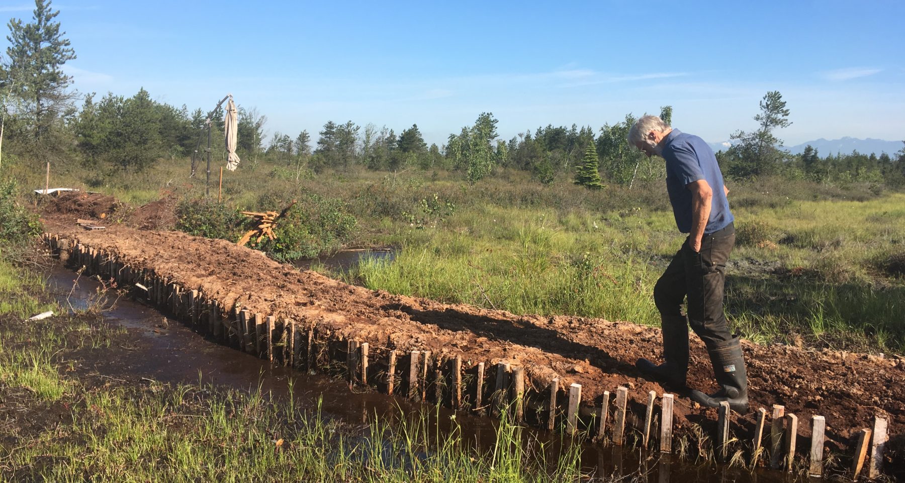
Over 110 km of drainage ditches were installed in Burns Bog during the peat extraction operations (1930s-1980s). These ditches have been progressively blocked by the City of Delta since 2001, although many of the ditches have also been blocked by beavers. To date, over 450 dams have been installed in the ditches, mostly by hand.
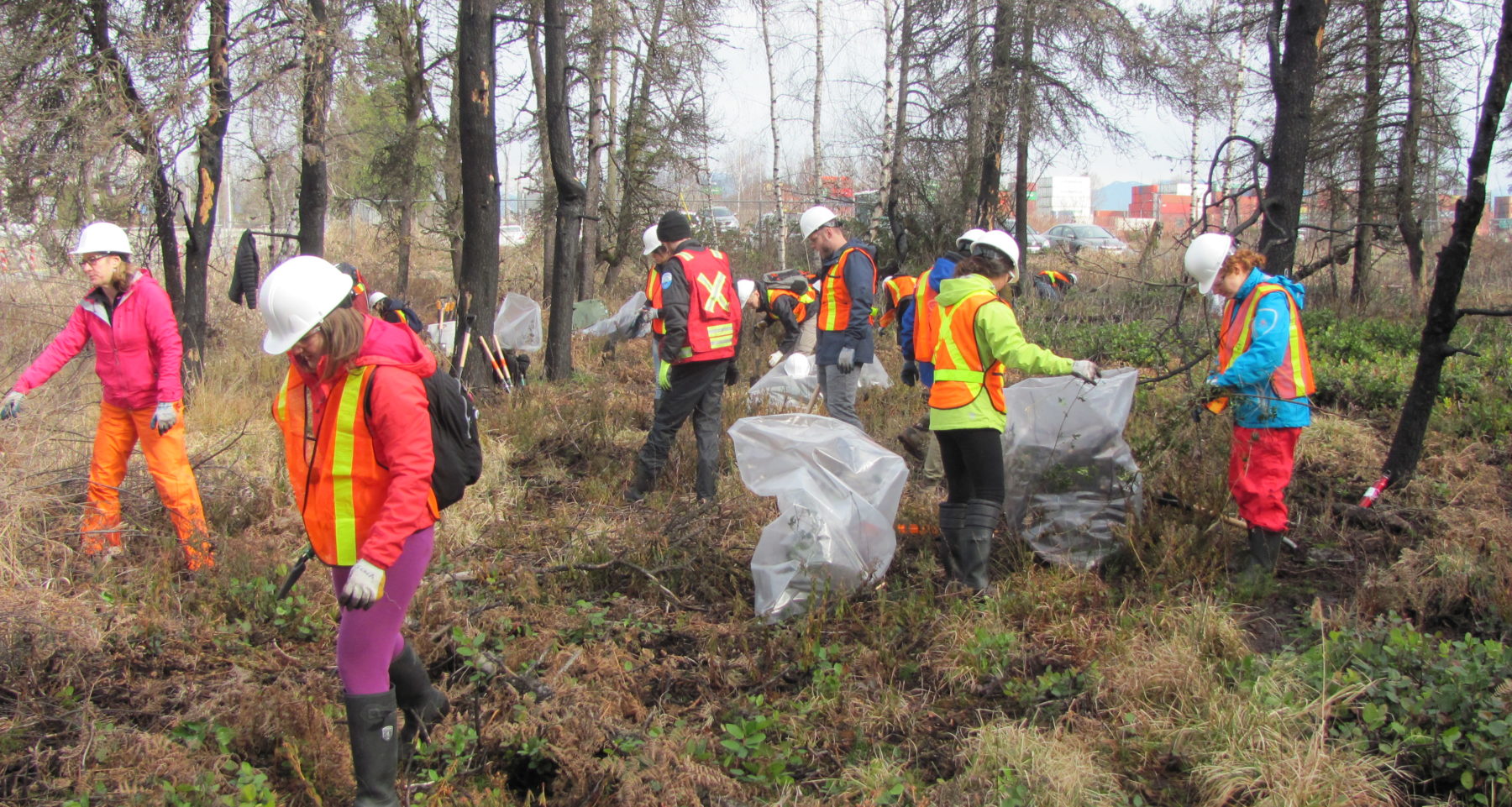
Invasive species are being managed by physical removal and use of herbicides. While it may not be possible to eliminate all invasive species from the 3,000 ha site, efforts are being made to manage the species of greatest concern and to keep other species from spreading.
Tree encroachment as a result of historic drainage is another threat to the bog ecosystem. Tree removal is being considered as a possible additional tool for both hydrological restoration and vegetation management. A tree-removal test plot is being monitored and tree seedlings are being removed from a recently burned site.
How this project reinstated appropriate physical conditions (e.g. hydrology, substrate)",:
As noted above, the hydrological conditions of the bog interior are being restored by blocking the ditches.
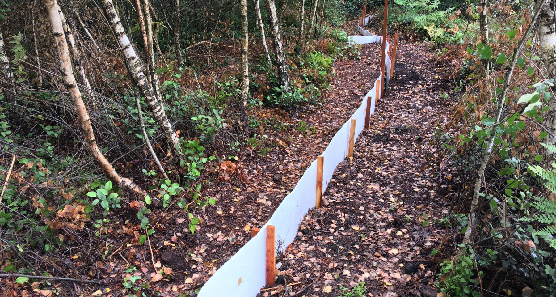
At the edge of the bog, where the wetland meets drainage ditches of adjacent farms, a different solution will be required to ensure that adjacent farmland is not flooded by bog water. An “underground wall”, which is essentially sheet piling, is being tested in one segment of the bog margin to determine if it is a feasible solution to the edge drainage threat.
Since only 1-2 m of surface peat was removed during the industrial peat extraction operations, a thick (5 m) layer of peat remains throughout most of Burns Bog. This provides the peat substrate and hydrochemical conditions (e.g. low pH) required for bog restoration. As the water table is restored, Sphagnum mosses will establish and restore the surface substrate conditions appropriate to a raised bog, i.e. a porous upper layer of peat known as the acrotelm.
How this project achieved a desirable species composition:
The ultimate goal of raising the water table is to achieve a desirable species composition, i.e. Sphagnum mosses and an open heath plant community. Invasive species are being managed and tree seedlings are being removed to encourage the spread of native species.
How this project reinstated structural diversity (e.g. strata, faunal food webs, spatial habitat diversity):
As the water table rises and Sphagnum and open heath plant communities establish, it is expected that structural diversity typical of a raised bog ecosystem will naturally follow.
How this project recovered ecosystem functionality (e.g. nutrient cycling, plant-animal interactions, normal stressors):
Ecosystem functionality is being indirectly restored through the blocking of ditches, raising of the water table, and restoration of characteristic raised bog vegetation. This work has been made possible because of the protection of the bog as an ecological conservancy area.
How this project reestablished external exchanges with the surrounding landscape (e.g. migration, gene flow, hydrology):
As a raised bog, which by definition only receives water from precipitation, Burns Bog is naturally somewhat isolated from the surrounding landscape in terms of hydrology in that it receives essentially no water inputs from the surrounding landscape. Historically, drainage from the bog was radial from the centre outwards and ultimately flowed north to the Fraser River and south to Boundary Bay. The peat extraction activities altered the drainage conditions in the bog so that approximately 70% of the bog’s drainage now leaves the bog from a single outflow point north to the Fraser River. Since farming and industrial uses have overtaken the historic lagg (margin) of the bog, it will not be possible to restore the external hydrological connections to historic conditions. However, a long-term goal of restoring Burns Bog includes establishing a new lagg around the perimeter of the bog within the current protected area boundary; observations in this and other local bogs suggest that this may be possible.
With respect to wildlife movement, Burns Bog is largely surrounded by highways and wildlife fencing. This limits the movement of large mammals (e.g. bear, deer, coyote), although there are some areas where these species are able to access farmland and other natural areas such as the Fraser River and Boundary Bay. Movement of small mammals is restricted but not entirely limited by the perimeter highways. Birds are able to continue moving between other important habitat areas in the region. To date, no efforts have been made to improve wildlife movement from the condition on the date of purchase. Since the date of purchase, additional highways and roads have been constructed at the bog margin, further limiting wildlife movement; one of these projects included a handful of wildlife tunnels, which met with limited success.
Activities were undertaken to address any socio-economic aspects of the project:
Burns Bog is highly susceptible to wildfire. With nearby operations including a major natural gas pipeline, regionally significant power lines, highways, wood products processing, and industrial facilities using large quantities of chemicals, management of fires in Burns Bog is of extreme socio-economic importance. The managing agencies have prepared a fire management plan for the bog, including operational maps and annual training for fire crews, and there are strict regulations in place to limit activities that are at high-risk for causing fires.
Ecological Outcomes Achieved
Eliminate existing threats to the ecosystem:
Designating most of Burns Bog as an ecological conservancy area in 2004 protected the lands from being used for agriculture and other purposes that would have resulted in further degradation to the ecosystem. Other parcels of the bog have been designated as conservation lands as well, with more expected to follow in future years. However, some privately-owned parcels in Burns Bog continue to be threatened with conversion to agriculture and industrial operations.
The installation of more than 450 dams in the drainage ditches has largely eliminated the threat of drainage in the bog interior, although the drainage at the margin of the bog has not yet been sufficiently addressed.
Some species (e.g. knotweed) are being successfully managed through herbicide application. Other species (e.g. garlic mustard, reed canarygrass, blackberry) will require further intervention.
A study on the effect of tree removal from 0.3 ha in Burns Bog on the local water table was inconclusive due to the small size of the trees that were removed. It has been observed, however, that desirable bog shrubs are establishing in the clear-cut area. The pine seedlings have not required further management, but birch regrowth was rampant in the clearcut site. The managing agencies are currently investigating methods for managing birch (e.g. cutting, pulling, herbicide injection/spraying).
Reinstate appropriate physical conditions",:
The water table is being raised and stabilized throughout the bog interior as a result of ditch blocking and beaver dams. The success of the underground wall pilot project at the bog margin will not be known for several years. Sphagnum mosses are establishing in many disturbed areas, but large-scale mapping is required to determine how widespread the restoration has been. Current research in Burns Bog using UAVs to map the spectral signatures of different Sphagnum species may allow land managers to answer this question.
Achieve a desirable species composition:
As the water table has increased and stabilized over the past 17 years of ditch blocking activities, Sphagnum mosses and other desired bog species have begun to reestablish in the peat-extracted fields. Removal of invasive species and trees should allow for further spread of desirable bog vegetation, although these vegetation management activities are more recent and have not yet produced the desired results on a large scale.
Reinstate structural diversity:
Due to the slow growth of bog vegetation, many of the peat-extracted fields are still in the early stages of recovery. However, observations suggest that these fields, which are currently mostly dominated by Sphagnum mosses and graminoids, will eventually progress to the open heath community that is typical of the undisturbed areas of Burns Bog.
As the water table is raised near the drier bog edges, it is expected that the trees will be replaced by Sphagnum and open heath communities. Some trees have already died off as a result of a higher water table in certain areas.
Recover ecosystem functionality:
As Sphagnum mosses continue to spread in the peat-extracted fields, it is expected that typical raised bog hydrological functionality will be restored. These are slow processes and it could be decades before we are able to determine that the restoration efforts have been successful. Extensive hydrological observations since 2005 suggest that hydrological functionality is returning to the peat-extracted fields. However, many studies in other restored bogs have shown that complete restoration of hydrological functionality may not occur, or at least not for many decades.
Since 29% of the bog was not directly disturbed by the peat extraction operations, it is believed that many biotic processes (e.g. plant-animal interactions) will be able to recover quickly once the extracted fields have recovered to a more typical bog vegetation. However, the focus to date has been on re-establishing the hydrological processes. Other aspects of the ecosystem have so far received less monitoring and research emphasis. More work is expected in this area in future.
Reestablish external exchanges with the surrounding landscape:
Since most historic hydrological connections with the surrounding landscape have been irreversibly altered from historic conditions, land managers plan to restore the hydrological, hydrochemical and vegetative conditions of a natural lagg within the current protected area of the bog. Further research is required prior to undertaking this major restoration project.
Factors limiting recovery of the ecosystem:
Climate change appears to be causing longer, drier, hotter summers in the region in which Burns Bog is located. Not only are wildfires increasingly prevalent in the region, but reduced precipitation has resulted in a lower summer water table in the bog in recent years. While unable to significantly impact global climate change processes, local land managers are hoping to buffer Burns Bog from these effects by raising the water table and promoting resilient bog plant communities.
The sheer size of Burns Bog is another factor limiting its recovery. As invasive species and trees continue to spread in the areas of the bog most affected by disturbance and drainage, the limited resources available to the land managers may not be enough to encourage bog species to recover in these areas. It is hoped that raising the water table will allow many bog processes to reestablish on their own, but it is recognized that further resources may be required.
Socio-Economic & Community Outcomes Achieved
Economic vitality and local livelihoods:
Hydrological restoration and vegetation management activities have created employment opportunities for several contractors. Funding has also been made available by the land managers and external agencies for several graduate student research projects.
Provision of basic necessities such as food, water, timber, fiber, fuel, etc.:
Restoration of Burns Bog does not provide basic necessities to humans.
Cultural dimensions such as recreational, aesthetic and/or spiritual:
One area of Burns Bog, the Delta Nature Reserve, is open to the public for recreation. There are gravel trails and boardwalks in the area that are popular for cycling, dog walking, running, walking, and bird-watching. The Burns Bog Conservation Society hosts an annual pilgrimage to raise awareness about Burns Bog; they also host nature day camps for children and a fun run to support their charity. None of the restoration activities have directly contributed to these benefits; however, ensuring the long-term survival of the bog through restoration indirectly supports these cultural dimensions.
Regulation of climate, floods, disease, erosion, water quality, etc.:
One major benefit of restoring Burns Bog is that intact bogs are excellent carbon sinks. Based on research by the University of British Columbia, Burns Bog is currently a carbon sink and a methane source. It is believed that, once the peat-harvested fields recover fully and change from their current state (Sphagnum and graminoids) to the desired state (Sphagnum and open heath), there will be less methane production and the bog will once again act as a carbon sink.
Has the project had any negative consequences for surrounding communities or given rise to new socio-economic or political challenges?:
To our knowledge, there have been no negative consequences of the restoration activities.
Key Lessons Learned
Management of undesirable birch trees in bogs is challenging because, once established, birch is tolerant of a high and fluctuating water table and has the ability to coppice when cut at the base. Pulling out small seedlings and the use of herbicide on larger trees are the management techniques being used in Burns Bog at this time. However, the long-term success rate of these techniques is not yet known.
Ditch blockages generally only raise the water table within about 15-30 m of the ditch. Depending on the historic effects of the ditch (e.g. drainage, tree encroachment, peat subsidence), it may not be possible to fully counteract the past effects of the ditch by blocking it. Other restoration actions, e.g. active vegetation management, may be required.
Long-Term Management
A long-term monitoring program was established in 2005, shortly after the purchase of Burns Bog and designation of the lands as an ecological conservancy area. The City of Delta monitors a network of water level stations across the bog on a monthly basis, while Metro Vancouver monitors dozens of permanent vegetation plots annually. The monitoring data provide these managing agencies with the information needed to focus restoration efforts (e.g. ditch blocking) on the areas requiring the greatest intervention. Restoration activities are expected to continue until the ecosystem has been determined to be stable and recovering on its own.
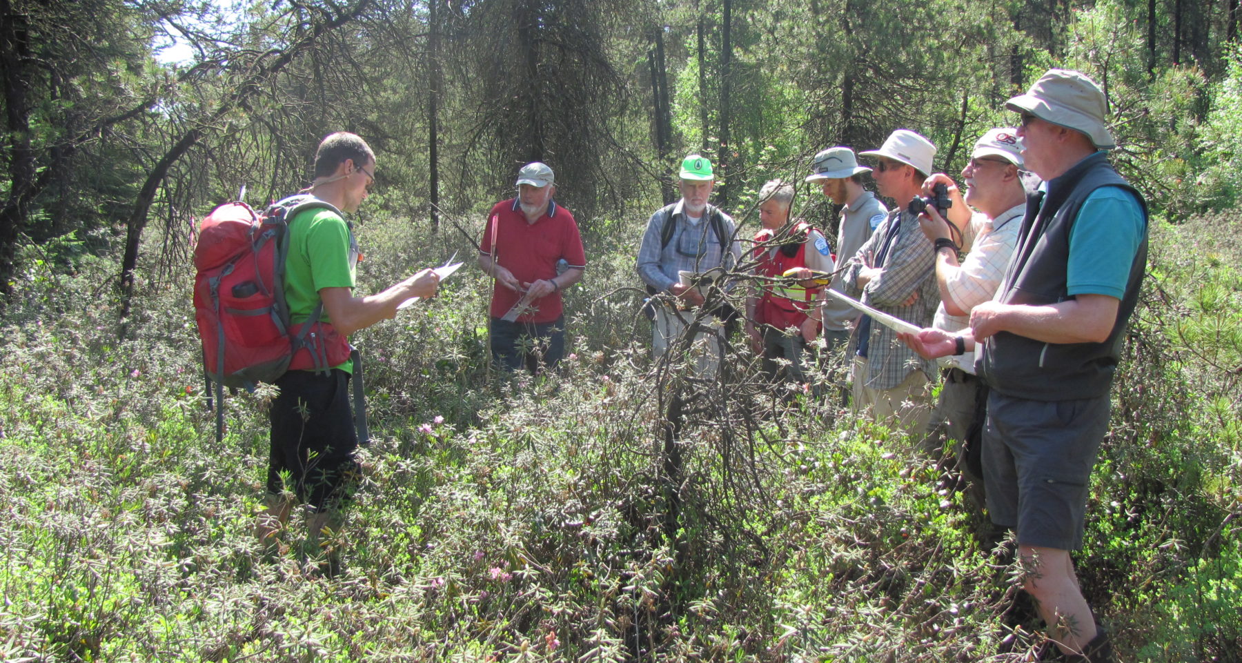
The Burns Bog Scientific Advisory Panel has been meeting with the managing partners since 2005, and will continue to advise the management team into the foreseeable future.
Related Research
Several peer-reviewed articles have been published about this project. Research is ongoing.Primary Contact
Name:
Sarah Howie
Affiliation:
City of Delta
City:
Delta
State:
BC