Overview
Situated on the southern coast of Maine is the town of Wells. Within 1600 acres of the Wells National Estuarine Research Reserve is Drakes Island tidal marsh. Presently, a road runs through the marsh leading to houses comprising a small community and Drakes Island Beach. Due to development in the area and the historical restrictions of the road and culvert originally installed in 1848, the marsh’s health greatly deteriorated. Vegetation composition, surface elevation, water levels and wildlife were all negatively impacted. In an effort to restore these aspects and reduce the impacts to the surrounding community (i.e. flooding), NOAA, the Town of Wells, the Wells National Estuarine Research Reserve and multiple other partners sought to install a less restrictive culvert to increase the tidal flow into the marsh. Monitoring efforts post restoration each year from 2005 up until present day revealed that several issues are still associated with the project including irregular flooding events. As a result, the final restoration status of the marsh is under debate.
Quick Facts
Project Location:
Wells, Maine, 43.3222329, -70.58052090000001
Geographic Region:
North America
Country or Territory:
United States of America
Biome:
Coastal/Marine
Ecosystem:
Coastal, Dune & Upland, Estuaries, Marshes & Mangroves
Area being restored:
77 Acres
Project Lead:
Wells Estuarine National research Reserve
Organization Type:
NGO / Nonprofit Organization
Project Partners:
-NOAA Community-based Restoration Program.
-Wells National Estuarine Research Reserve
-The Gulf of Maine Council
-Reserve Management Authority
-Town of Wells, Maine
-Conservation Law Foundation
-Restore America’s Estuaries
-Rachel Carson National Wildlife Refuge
-Corporate Wetlands Restoration Partnership
-Maine Coastal Program
-U.S. Fish and Wildlife Service
Location
Project Stage:
Monitoring & Evaluation
Start Date:
2003-03
End Date:
2007-12
Planning \ Design:
36
Implementation:
12
Post-Implementation Maintenance:
24
Monitoring & Evaluation:
36
Primary Causes of Degradation
Agriculture & Livestock, Dams & Hydrology, Fragmentation, Urbanization, Transportation & IndustryDegradation Description
1848 is the year noted for the initial restriction of the marsh due to the creation of a dike directly across the marsh. A road built on top of the dike and the placement of a box culvert underneath the road followed about 70 years after which further diminished the marsh quality. Also during the mid-1800’s, the marsh was drained and converted to hay fields and a pasture for livestock, a much too common occurrence back then that led to drastic losses of wetlands throughout New England. This caused a cascade of detrimental effects including reduced salt water inflow, little to no tidal exchange due to the greatly undersized culvert, and tidal flooding reduced to a maximum of about one foot across the marsh. Up until 1988 when the initial box culvert installed in the 1950’s broke, the marsh was nearly converted to a freshwater and brackish ecosystem. Although tidal flow was lowered, flooding was more prominent towards the houses near the marsh, especially during spring tide events, as the water did not exit the marsh quickly enough. Decreased tidal flow also reduced the influx of sediment into the marsh. The coupling of lower tidal flow and influx of sediment eventually led to soils oxidizing at a higher rate, ultimately leading to subsidence of the marsh.
The culvert is also a hindrance to biotic aspects of the system as it limits movement of fish and other estuarine animals into and out of the marsh. One major effect that occurred due to decreased tidal exchange is lowered salinity levels and subsidence of the marsh overall, which allowed the common invasive reed (Phragmites australis) to establish and the native cattail Typha latifolia to spread. The invasion further led to unsuitable habitat and lower abundances of native fish and nekton such as the mummichog (Fundulus heteroclitus) that were previously abundant
Defining the Reference Ecosystem
The reference ecosystem is based on diverse sources of information (e.g. multiple extant reference sites, field indicators, historical records, predictive data).Reference Ecosystem Description
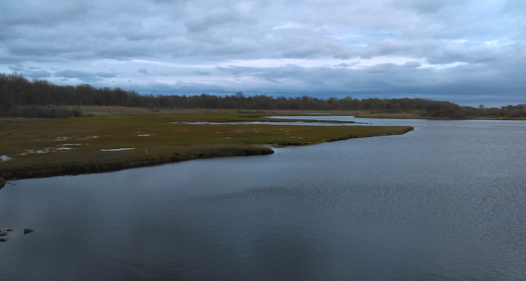
The marsh on the west side of the impoundment (Drakes Island Road) was used as a pre-disturbance reference for restoration measures. This marsh, is directly downstream of the impacted marsh of Drakes Island and connects to the Webhannet River. Species composition, water levels, and species densities, as well as abundances, are all included as a basis for restoration of the impacted marsh. The reference marsh was composed of primarily high marsh habitat with creek channels and pools in a mosaic throughout the area. Sedimentary records were also examined along with assessing the reference marsh to infer the impacted marsh was several feet higher than pre-disturbance.
Project Goals
- Improve tidal flow to establish previous salinity levels and natural tidal patterns in the marsh to limit spread of Phragmites australis.
- To increase high marsh habitat and increase population of Spartina patens. Flow will be increased but high tidal flow will be limited.
- Manage water levels for nesting areas of Saltmarsh sparrow (Ammodramus caudacutus)
- Subsequently improve habitat for native fish and nekton communities
- Reduce flooding in surrounding developed areas
Monitoring
Monitoring Details:
Two years before any decisions were made, several studies were conducted on the marsh to assess its status and composition. Stakeholder opinions were taken into account along with hypothetical modeling of different scenarios on actions to take for the marsh. The best model to benefit all equally was based on the idea to reinstall a less restrictive culvert and self-regulating tide gate (SRT). Monitoring efforts were also conducted immediately before the installation and after the installation for the following two years.
The Rachel Carson National Wildlife Refuge led the monitoring using wildlife (including nekton and the salt marsh sparrow), vegetation composition, and hydrologic characteristics such as groundwater levels and salinity as the main ecosystems attributes to measure success.
Monitoring is still ongoing yearly with efforts focusing primarily during the growing season.
Start date, including baseline data collection:
Three years prior to initial start date.
End Date:
Ongoing
Stakeholders
The Town of Wells, Rachel Carson National Wildlife Refuge, The Wells National Estuarine Research Reserve, and the community of residents that reside on Drakes Island were all the primary stakeholders in the project. All major stakeholders were involved in the project from the start and communication through meetings, press releases, and general news circulation was administered throughout the project’s time line. The opinions of all people working on the project were included in the creation of management and monitoring plans, especially those of the community residents. In particular the views of the residents led the maintenance decisions post construction of the new culvert and tide gate.
Description of Project Activities:
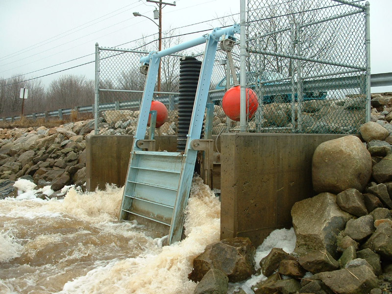
Restoration began with the removal of the old culvert, which measured approximately 0.9 meters in width, underneath Drakes Island Road and the installation of a new 1.5 by 1.2 meter box culvert. As well as the new culvert a self-regulating tide gate (SRT) was also implemented on the southern side of the road along with flashboards on the northern side to be able to physically manage the water levels coming into and out of the marsh. The size of the culvert was an important decision as these measurements would only allow for a partial restoration but not a full restoration.
How this project eliminated existing threats to the ecosystem:
The new culvert would potentially allow more tidal flow into the marsh, increasing the salinity overall and thus hopefully causing the die back of Phragmites australis and Typha latifolia.
How this project reinstated appropriate physical conditions (e.g. hydrology, substrate)",:
A less restrictive culvert would reinstate a more natural tidal regime into the marsh and so restore the hydrology that has been previously disrupted. The restoration of a natural regime would also hopefully raise the level of the marsh by increasing inundation periods which would eventually cause the soils to change back to anaerobic conditions and reduce subsidence and decomposition of the vegetation.
How this project achieved a desirable species composition:
Construction of an SRT and wider culvert would be expected to alter the species composition to a more salt-tolerant and high marsh composition similar to that of the reference marsh downstream. Species found in this area include Spartina alterniflora, Plantago maritima, Distichlis spicata, and Limonioum carolinianum.
How this project reinstated structural diversity (e.g. strata, faunal food webs, spatial habitat diversity):
N/A
How this project recovered ecosystem functionality (e.g. nutrient cycling, plant-animal interactions, normal stressors):
Low lying pools within the marsh will become more accessible during tidal events where water level is higher, reducing discontinuity of nekton use throughout the marsh. Cycling of nutrients from the downstream marsh and estuary should also be improved from an increase in tidal flow.
How this project reestablished external exchanges with the surrounding landscape (e.g. migration, gene flow, hydrology):
A new culvert will reestablish the flow that has been constrained by the impoundment of Drake Island Road between the impacted marsh and the downstream marsh as well as flow to the Webhannet estuary nearby. With the culvert being the only primary passage into the upstream marsh, wildlife passage will also be improved.
Activities were undertaken to address any socio-economic aspects of the project:
The self-regulating tide gate and flashboards installed would allow adjustments of water into and out of the marsh. This approach will allow accommodation for community members and town officials to control the water to desirable outcomes.
Ecological Outcomes Achieved
Eliminate existing threats to the ecosystem:
Phragmites australis and Typha latifolia continue to persist in the marsh post construction. Tidal levels were not increased enough in the first year after the new culvert was installed and so led to drier conditions across the marsh and some spread of the invasives.
Reinstate appropriate physical conditions",:
Groundwater levels eventually increased up to 14.4 cm below the surface in the last few years of noted monitoring which was higher than the reference marsh. Pool levels and their salinity levels remained much lower and failed to reach management goals. Total flow levels were recorded as 13 centimeters lower than the set goal in the management plan and because of this do not reach areas of the marsh that would provide sufficient flooding to maintain a salt marsh habitat.
Achieve a desirable species composition:
The second year of monitoring showed a positive increase in growth of high marsh plant species, yet, tidal flow was still restricted enough to allow expansion of Phragmites due to the lowered salinities throughout the marsh. Composition of nekton and fish species varied slightly from the reference marsh but it was significantly observed that the densities of species and abundancies were much lower in the impacted marsh. Salt marsh sparrow numbers were also seen to decrease yearly since pre-construction and still remain lower than in the reference marsh.
Reinstate structural diversity:
In the first year post construction, pools throughout the marsh resembled those of the downstream marsh in habitat complexity more than before. This did not last long and the most current monitoring concludes that structure of the reference and impacted marsh are not uniform in comparison.
Recover ecosystem functionality:
The result of lower tidal flooding caused many of the pools to lose functionality as numerous pools dried up completely and others were diminished in size. One major negative consequence of this was the lowered fish and nekton utilization of these pools. Even though it was not focused on in monitoring efforts, nutrient flow in and out of the marsh is assumed to be hindered. Fish and nekton are important components in nutrient cycling and decomposition of matter in a salt marsh.
Reestablish external exchanges with the surrounding landscape:
The wider culvert allows better passage for fish and nekton communities into and out of the marsh but the hydrology is still inhibited. Although wildlife use is being observed, longer term trends of use and residency in the marsh will have to be recorded to make a better determination of the functionality of the restored marsh. Especially during spring and neap tide events, water is being held upstream of the impoundment and causing longer inundation periods than usual.
Factors limiting recovery of the ecosystem:
Even though a new larger culvert and regulating tide gate was installed, the water flow is still somewhat restricted based on recent research. Due to the tide gate being improperly installed at the wrong elevation, poor drainage is an issue in the marsh and water is being held for extended periods within the marsh. The present state of the marsh is considered low marsh due to the dominance of S. alterniflora compared to the reference high marsh downstream. Along with varied zonation across the marsh, this outcome was not intended for one of the project goals.
Public opinion of residents on Drakes Island and the stakeholders were in opposition to fully restore historical tidal regimes to the marsh due to the likely possibility of people’s homes being flooded.
Socio-Economic & Community Outcomes Achieved
Economic vitality and local livelihoods:
While not officially stated, opinions from stakeholders have suggested an increase in recreational benefits in the marsh such as kayaking and fishing, as well as positive change in overall appearance of the marsh. Flooding of houses has generally decreased due to continual adjustments of the culvert. The project has been also seen to reduce the risk of flooding and damage during storm events of Drakes Island Road itself.
Has the project had any negative consequences for surrounding communities or given rise to new socio-economic or political challenges?:
A consensus from the community is still in question as to whether the project was a success. Concerns are still being voiced to make further adjustments to the culvert and tidal levels but they contradict with the ecological outcome of the marsh.
Key Lessons Learned
The Drakes Island Marsh restoration project demonstrated the importance of cooperative actions and views of all present stakeholders. Ecological and community driven goals conflicted with each other to a degree in this project. While all goals couldn’t be completely accomplished, both sides suffered drawbacks. For example, the marsh has lower tidal levels in pools than the established goal and the community’s concern about high tide levels during spring and neap tides. Compromising proved to be a solution in this project to reach the majority of goals.
Research and monitoring allow a quantitative assessment for the state of the restoration and will eventually provide information on how to better manage the system. Yet, because of the extended time it takes to conduct monitoring and research efforts, knowing which actions to take and when to take them was not immediately apparent. Many responses to adjustments (in this case from the SRT) such as vegetative composition, would not be substantially seen in the marsh for weeks to months at a time and perhaps longer. This conflicted with the communities and Town’s reasoning to make adjustments faster than the ecosystem would respond. It is greatly important to have concrete goals in mind at the start of a project and even more importantly to follow those goals until an outcome is achieved.
Long-Term Management
Long-term maintenance of the Drakes Island Marsh ecosystem so far is based around the self-regulating tide gate and succeeding adjustments to it and the accompanying flashboards. No other active management methods are in place for the marsh but continuing monitoring of salinity, surface, and groundwater levels are being done annually. Wildlife and vegetative surveys are also done throughout the year by members and volunteers of the Rachel Carson Wildlife Refuge. The Wells Estuarine Reserve is also aiding in the long term monitoring while the Town of Wells and its Technical Advisory Committee are responsible for maintenance of the tide gate.
Sources and Amounts of Funding
~$753,816 USD. Contributions for funding was provided by the Conservation Law Foundation, Restore America’s Estuaries, Reserve Management Authority, Wells National Estuarine Research Reserve, Gulf of Maine Council, Town of Wells, and NOAA (National Oceanic and Atmospheric Administration).
$277,287 was provided by NOAA while the remaining funds were a composite from the other listed entities previously stated.
Primary Contact
Name:
Susan C. Adamowicz
Affiliation:
U.S. Fish and Wildlife Service - Wildlife Biologist
City:
Wells
State:
MA
Organizational Contact
Name:
Kyle M. Lemoine (Author of this case study)
Affiliation:
Undergraduate Student - University of Rhode Island
City:
Kingston
State:
RI
Email:
[email protected]