Overview
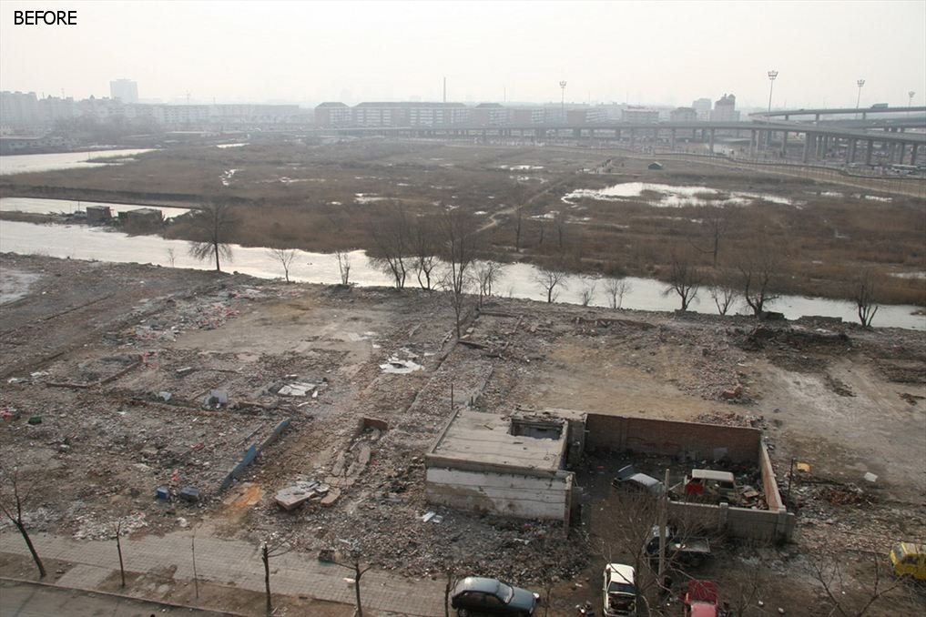
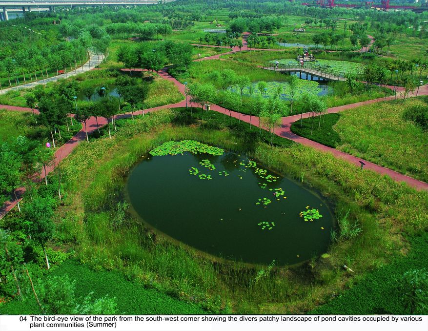
In 2005, in response to calls from residents to improve a 22-hectare deserted shooting range used as a garbage dump, the municipal government of Tianjin, China decided to create a park. The government contracted landscape architecture firm Turenscape to create The Bridge Park in downtown Tianjin. Rather than just create a traditional park, the design aimed to use adaptive regeneration to restore a self-producing ecosystem to the landscape and in addition to a beautiful urban park. Simple filling-cutting technology was used to create micro-topography to form landscape “sponges,” letting nature do the work of collecting acidic rainwater, neutralizing alkaline soils, repairing urban brownfields, and ultimately reintroducing the processes and structure of the native wetland predominant in the area. The guiding principle was to combine the processes of ecological restoration and ecosystem services. The natural process of plant adaptation and community evolution transformed the greyfield into a low-maintenance urban park; providing diverse nature’s services for the city including containing and purifying stormwater; improving the saline–alkali soil, providing opportunities for environmental education and creating a cherished aesthetic experience.
Quick Facts
Geographic Region:
Asia
Country or Territory:
China
Biome:
Freshwater
Ecosystem:
Freshwater Wetlands
Area being restored:
22 hectares
Project Lead:
Turenscape
Organization Type:
Consultant / Consulting Company
Project Partners:
Tianjin municipal government
Project Stage:
Completed
Start Date:
2005
End Date:
2008
Primary Causes of Degradation
Contamination (biological, chemical, physical or radiological), Urbanization, Transportation & IndustryDegradation Description
The site was first used as a shooting range. The site was low and there were some fish ponds. Rapid urbanization changed the peripheral shooting range into a garbage dump and drainage sink for urban stormwater. The site became heavily polluted, littered, deserted, and surrounded with temporary rickety structures. The site was covered with garbage, the sewage was flowing, and the salinization was very serious. The soil was contaminated and highly saline and alkaline. The site area is densely populated at the south and east boundaries, the site is bounded on the west and north sides by a highway and an overpass.
Defining the Reference Ecosystem
The reference ecosystem is based on diverse sources of information (e.g. multiple extant reference sites, field indicators, historical records, predictive data).Reference Ecosystem Description
Tianjin is bordered by Yanshan in the north of the Bohai Sea. Plains, tidal flats, wetlands, low altitudes and saline-alkali land are the most widely distributed and common natural landscapes here along the northeastern coastal region of China. The groundwater level in the area is high and the water system is developed. This geographical environment brings inspiration and inspiration to the park design. Thus, the reference ecosystem has flat, wild grass landscapes full of wetlands and salt marshes with highly diverse water and alkaline-sensitive native vegetation. Minor elevation changes will bring about changes in the physical and chemical properties of the ground soil, including water and salinity, which will ultimately be reflected in the plant community.
The benchmarks used to evaluate restoration success is measuring soil contamination concentrations before and after implementation, specifically reduction in soil salinity and alkalinity. The successful return and survival of native vegetation and fauna such as weasels to the site will also indicate restoration success.
Project Goals
- Improve soil quality by remediating the contamination of the site caused by the garbage dump and urban runoff solve the problem of soil salinization.
- Retain stormwater in the depressions.
- Eliminate the threat of habitat destruction in the area and restore the native wetland habitat of the area to protect native biodiversity.
- Provide diversified ecosystem services for the city, including rainwater harvesting, noise reduction, pollution treatment, and providing good recreation space.
- Utilize the natural process to let nature do work and repair the ecosystem.
- Form an efficient and low maintenance ecological park.
- Create an educational space where residents can learn about the native landscape through outdoor teaching.
- Create a low-maintenance park by creating an adaptive landscape which utilizes the natural plant community to stay wild and “messy” while cleaning soil and water.
- Allow nature to co-design the landscape
- Create a landscape that acts as a carbon sink
- Pollution treatment
- Waste recycling
Monitoring
Monitoring Details:
The environmental restoration performance of Tianjin Bridge Park was measured by calculating the stormwater captured by the park in wetland depressions. The calculation was done by adopting the rainfall data of Tianjin Station (data from China Meteorological Science Data Sharing Network, China Ground Climate Standard Value Annual Value Data Set (1971-2000)), according to different material runoff coefficients, combined with topography and zoning map before and after construction. The resulting formula can be used to obtain the amount of rainwater collected by the Bridge Park. A SWMM simulation was used to generalize the watershed before and after the construction of the park, and a model was built to understand the impact of the wetland park.
Soil alkalinity and pH levels were also monitored before and after project implementation.
Stakeholders
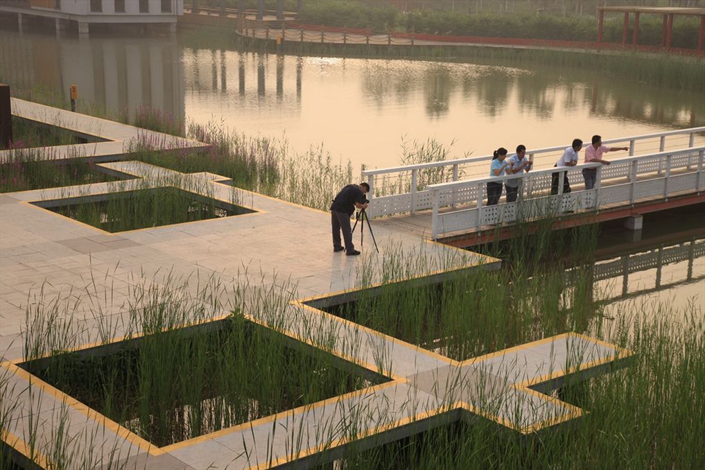
The surrounding community has a population of nearly 300,000. Red-colored asphalt paths that weave through the palettes with interpretive signs and wood platforms that extend above the ponds and cavities were installed to allow visitors to engage with the restored native wetland.The nearby residents to the park were asked to answer questionnaire surveys about how the park implementation and educational opportunities altered their conception of ecological restoration. Tourists visiting the park were also surveyed about their experiences. Educational signage with scientific explanations for each type of natural system in the park including information about water, vegetation, and species, were installed to help visitors gain knowledge about the local natural system while experiencing the beauty of the native landscape. Commentary cards were also made available to understand the effectiveness.
How this project eliminated existing threats to the ecosystem:
A large threat to the site area previously was habitat destruction. The practitioners used the framework of “emergency service bionic restoration technology” to restore habitat to the project area. The design strategy mainly includes two aspects: one is to set up a set of artificial wetland system through terrain design to collect and filter rainwater; and the other is to use the collected rainwater to form water quality and water quality with different pH. Native plants and constructed wetland landscapes to achieve ecological restoration on saline-alkali land. The first strategy is the urban rainwater management green sponge technology described in 6.3 of this chapter, but it is also an important basis for realizing the biomimetic restoration technology of ecosystem services.
How this project reinstated appropriate physical conditions (e.g. hydrology, substrate)",:
The original site of Qiaoyuan Park was severely salinized. Native vegetation and topography that encourages soil infiltration was used to lower the pH of the soil and water, improving overall conditions.
How this project achieved a desirable species composition:
Through the ecosystem service bionic repair technology module, 48 species of arbor, 91 species of herbs, and 6 species of animals were selected and added to the wetland park. These species were selected as an “adaptation palette” such that they would create a “messy” natural aesthetic to the park, acting as a foundation for adaptative regeneration, to mimic the natural seasonal changes that would occur in the historic native wetland. Seeds of mixed ground cover and wetland species were sowed initially, and other native species were allowed to grow wherever they took root. Selected species included: Rosmarinus officinalis, Melampodium Lemon Delight, Caragana sinica, Ageratum conyzoides, Erigeron annuus, Catsia tora Linn Ligularia sibirica (L.) Cass., Herba Polygoni Perfoliati, etc. The clustered forest population is arranged between the blisters, and the most abundant willow tree in the area is used as a key tree species for the landscape.
How this project reinstated structural diversity (e.g. strata, faunal food webs, spatial habitat diversity):
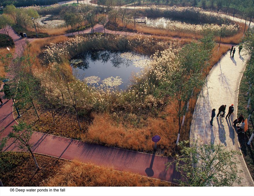
The project reconstructed the site area terrain using different depths of pits and ponds with the objective of collecting and purifying rainwater, while simultaneously promoting the natural succession of plants to create a variety of habitats.
The core of Habitat's habitat design lies in the design of micro-topography and the design of water network. Through the terrain design, 21 pits and depressions with a radius of 10-30m and an altitude of 1-5m are formed. These pits and ponds are used to collect all the rainwater on the site. Each depression has different elevations. The altitude difference is 10cm. It is deep and shallow. Some deep waters are 1.5m deep and are directly connected to groundwater. There are shallow blisters; seasonal blisters are only in the rainy season. There is stagnant water; some are above the hills, forming a dry land. Different depressions have different water and saline conditions, forming habitats suitable for the growth of different plant communities. In the process of creating the terrain, the domestic garbage of the site is used locally for terrain reconstruction.
Ecological Outcomes Achieved
Eliminate existing threats to the ecosystem:
Seasonal changes in plant species occur and integrate the create a beautiful and "messy" native landscape. The park also successfully balances the constraints of the urban landscape and thousands of visitors to the park a year with preserving the integrity of the delicate native vegetation and wetland habitat quality by using elevated platforms extended over the habitat.
Reinstate appropriate physical conditions",:
Improved soil alkalinity in the dry ponds and water quality in the wet ponds as evidenced by field measurements. Three samples of water and soil were taken from the site in November 2011, August 2012 and December 2012, respectively, and the pH value was tested. The results showed that the pH of the water was reduced from 7.7 to 6.8 in 2012. Soil pH decreased from 7.7 and now fluctuates around 7.2. Water pH levels dropped from 7.4. to 7 or less. Overall, soil and water quality improved.
Achieve a desirable species composition:
The restoration increased the habitat value of the site. After implementation, the water-sensitive adaptive communities that were introduced to the new wetland landscape were able to survive and fluctuate across the four seasons. The number of herbaceous plant species increased from 5 on the existing site to 58 following park construction, to 96 two years after the park opened. Ducks, geese, foxes, hedgehogs, rats, and weasels have been observed on the site.
Reestablish external exchanges with the surrounding landscape:
2,950 shady trees and 8997 m2 reeds absorb about 539 tons of carbon per year, worth about 4.55 million yuan or $7,200.
The annual collection of rainwater from surrounding roads and roofs totaled about 1.16×10⁸L, and the total amount of groundwater replenished was about 1.0×10⁷L; the accumulation of accumulated rain and flood reached 7.8×10⁷L; the reduction of rainwater runoff was nearly 100%, nearly 3.2×10⁷L. The results showed that after the completion of the construction, the evaporation was reduced by more than half; the surface runoff was reduced by more than half; the amount of rainwater infiltration increased, which was more conducive to replenish the groundwater
Socio-Economic & Community Outcomes Achieved
Economic vitality and local livelihoods:
Today, the Bridge Park has become an important tourist destination in Tianjin. Every year 350,000 people visit the park, of which over 50% are senior citizens and 40% are children. The park improves access to green space for the 20,000 nearby residents who can now walk to a park in less than 15 minutes. The park is also served by 26 bus routes.
The low-resource demands of natie vegetation compared with the traditional park green space which requires heavy irrigation, this park can save nearly 959,000 yuan per year. According to the original site relics, the site pavement 84.5m3 was transferred to the original sleepers, saving about 160,000 yuan in paving costs. The park ecological wetland bubble based on the ecosystem service bionic repair technology module does not require weeding, trimming, irrigation and fertilization for maintenance and management, and can save 118,000 yuan per year in maintenance costs. The use of native vegetation for planting and planting is not only conducive to the repair of water problems such as rain and water, water quality, but also saves 31,000 yuan per year. The commercial building on the south side of the park can be rented for 700,000 yuan per year. Additionally, the project saved approximately $25,500 in lumber costs by reusing 84.5 cubic meters of old railroad ties in the construction of the observation platforms and bridges.
Cultural dimensions such as recreational, aesthetic and/or spiritual:
In addition to the ecosystem restoration objectives, the Bridge Park is aesthetically sensible and designed to incorporate educational components. About 600 children and 500 students from nearby schools and educational organizations can participate in the park's environmental education experience mission.
According to a questionnaire survey, the surrounding 20,000 households generally improved their awareness of the improvement of the ecological environment, and about 83.2% of the tourists agreed with the ecological design of the park.
The recreation experience of the surrounding residents has been improved. The residents surveyed spend at least 15 minutes a day on this urban green space for leisure walks. A trail system with elevated platforms over the wetlands and resting places were introduced into the park design.
Regulation of climate, floods, disease, erosion, water quality, etc.:
The park's noise reduction capability can reduce noise from 70dB to 50dB. The wetland park is designed to collect stormwater runoff and filter water, which will aid in flood control and water quality.
Key Lessons Learned
- This is a successful example of a design approach to reestablish natural functions and let the dynamic processes of adaptation and succession occur. The project was successful in creating diverse habitats that require minimal management in an urban area while still allowing for people to visit and engage with the landscape.
- Key steps in the design process included: careful planning and plant selection, experimentation with species, monitoring of progress during the construction phase as plants became established, and adjusting the design accordingly to achieve the best performance.
- The interconnected pedestrian paths that surround each of the ponds are a defining feature of the site. However, this dispersed pedestrian network makes circulation, privacy, and group activities challenging compared to a site with more selectively-place trails.
Sources and Amounts of Funding
$14.1 million USD
Other Resources
Rottle, Nancy, and Delia Lacson. “Tianjin Qiaoyuan Park: The Adaptation Palettes.” Landscape Performance Series. Landscape Architecture Foundation, 2011. https://doi.org/10.31353/cs0180
The Contemporist – March 30, 2012
Turenscape – Tianjin Qiaoyuan Wetland Park
ASLA Honor Award for General Design, 2010
World Architecture Festival Awards Completed Landscape of the Year, 2009
China Housing and Urban and Rural Construction Ministry, National Habitat Award, 2008
Primary Contact
Name:
Kongjian Yu
Affiliation:
Turenscape