Overview
The South Paraíba Valley, Brazil, is one of the more degraded areas of the Atlantic forest regions. It’s probable that the occupation of the valley by sugar cane farms, coffee plantations and cattle fields promoted isolation between the Sea Mountains and the Mantiqueira Mountains over the last 300 years. The more recent industrialization and urban occupation of the valley has exacerbated this isolation.
The company Eletrobrás FURNAS S.A, a regional public utility, has made investments in restoration projects in the area. Moving forward, it is essential to direct these projects to permanent protected areas (APP) and national parks, with the goal of connecting remaining fragments.
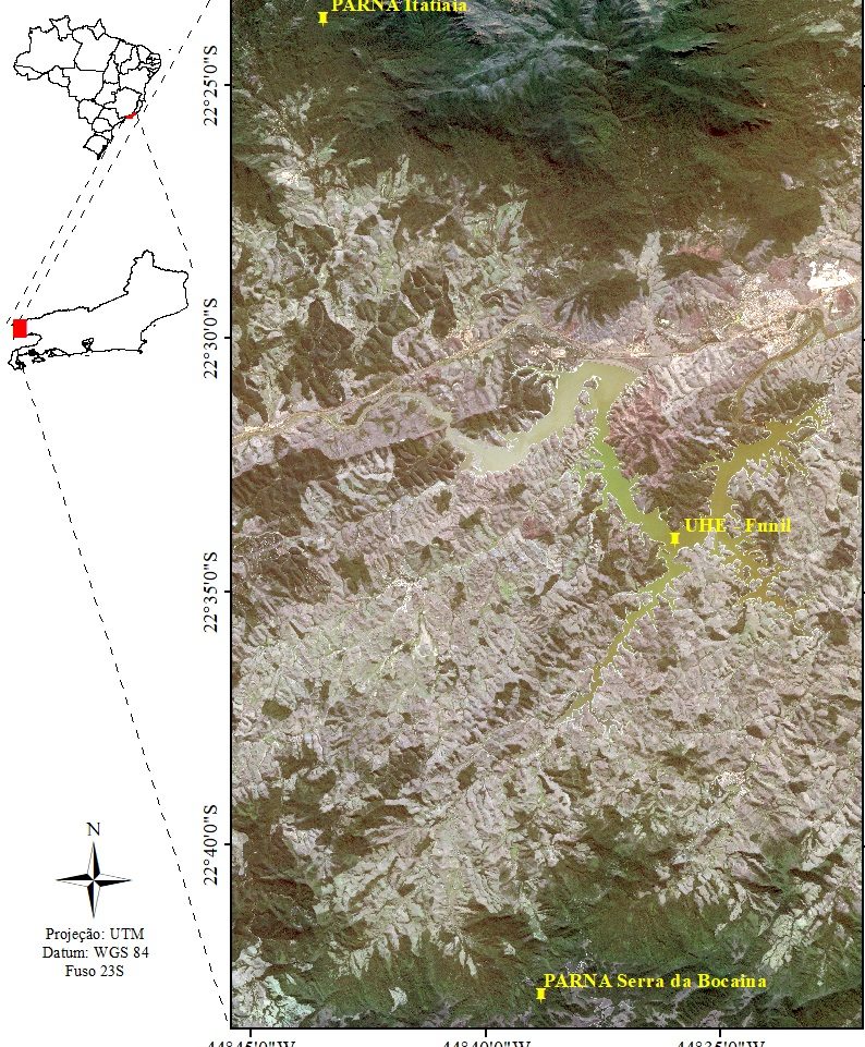
In the Sea Mountains and Mantiqueira Mountains, there are two National Parks of imperative importance, the National Park of Itatiaia and the National Park of Bocaina Mountains. The objective of this project is to create an ecological corridor linking these two national parks using the APP of rivers and reservoir owned by Eletrobrás FURNAS S. A. This project identified the path of the corridor and calculated the necessary area of restoration of the ecological corridor.
Quick Facts
Project Location:
Unnamed Road, Resende - RJ, Brazil, -22.563590920893002, -44.59236351015625
Geographic Region:
Latin America
Country or Territory:
Brazil
Biome:
Tropical Forest
Ecosystem:
Tropical Forest - Moist Broadleaf
Area being restored:
A corridor that connects two National Parks, and crosses an artificial reservoir
Project Lead:
Federal University of Lavras
Organization Type:
University / Academic Institution
Project Partners:
Eletrobrás FURNAS S. A.
National Park of Itatiaia
National Park of Bocaina Mountains
Prof. Dr. Eduardo van den Berg – Federal University of Lavras
Msc. Flávia Freire de Siqueira – Federal University of Lavras
Location
Project Stage:
Planning / Design
Start Date:
2017-04
End Date:
2022-04
Primary Causes of Degradation
Agriculture & Livestock, Dams & Hydrology, Deforestation, Fragmentation, Urbanization, Transportation & IndustryDegradation Description
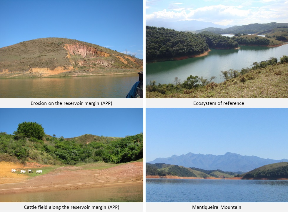
The degradation of the South Paraíba river’s basin began early in Brazil’s history, starting with the exploitation era of the Brazilian colony, where the gold route and creation sugar cane farms, coffee plantations and rice paddies degraded the meadows of the South Paraiba river. Later in the 1940s, the coffee production was replaced with cattle fields and eucalyptus plantations.
In addition to resource extraction and land use change, the area also functioned as a “natural path” through the interior of Brazil’s Southeast region. The 1951 inauguration of the President Dutra Highway, connecting the capital cities São Paulo and Rio de Janeiro, increased industrialization and real estate occupation in the region, factors that resulted in further environmental degradation.
Defining the Reference Ecosystem
The reference ecosystem is primarily based on contemporary reference sites or existing analogues of the pre-degradation ecosystem.Reference Ecosystem Description
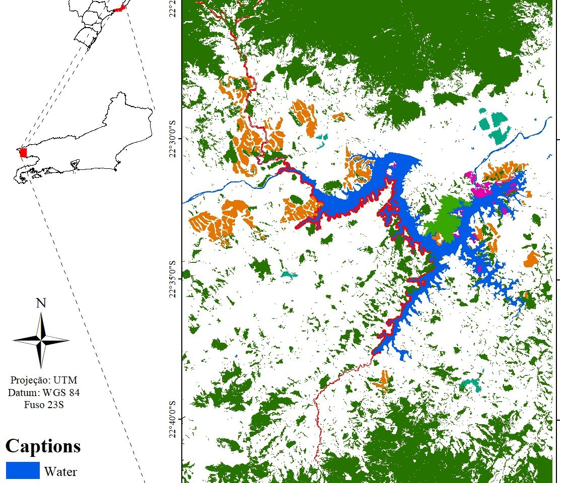
Six reference fragments were selected and categorized into three different successional stages, three age classes were set: Class 1 (young forests within 10 to 20 years), Class 2 (intermediate forests within 30 to 40 years) and Class 3 (older forests, with more than 60 years), each class had two fragments.
We sampled 3,460 trees classified in 39 families and 168 species. The older fragments (more than 60 years) of the reference ecosystem presented a higher richness of species then the fragments of 10 to 20 years old. The young fragments showed a higher rate of pioneer species 39.6%, followed by early secondary 48.9%, and late secondary 11.5%. The fragments within 30 to 40 years old showed 21.05% of pioneers, early secondary 64%, and late secondary 14.4%. Fragments with more than 60 years old presented 6.9% of pioneers, 54.4% of early secondary and late secondary 38.4%. In terms of forest structure, older fragments (more than 60 years old) showed a higher canopy height 10m +2, trees per parcel 88+2 and basal area 1.1m2/hectare +0.1
Project Goals
- Diagnose the situation of the area between the national parks using landscape metrics;
- Propose a species list for the restoration that follows the composition of the referential ecosystem;
- Propose an ecological corridor that uses the APP and connects the National Park of Itatiaia and the National Park of Bocaina Mountains.
Monitoring
The project does not have a monitoring plan.
Stakeholders
Eletrobrás FURNAS S.A. have a nursery garden with capacity to produce 120,000 plants seedlings per year – all of them natives from the Atlantic Forest. This production can be streamlined to give the necessary support to the restoration of the priority area (ecological corridor). However, FURNAS is not the owner of all the APP that surrounds the reservoir, about 80% of this area is third party owned. One way to encourage public and private support of this restoration project would be promoting the corridor in an inclusive way.
With the promotion of this project, it is possible to attract private companies that may have an obligation to recover areas due environment debts, or those that have an interest in contributing to the first corridor between the Sea Mountains to the Mantiqueira Mountains and reconnecting fragments after 300 years of isolation.
Ecological Outcomes Achieved
Socio-Economic & Community Outcomes Achieved
Key Lessons Learned
The necessity of choosing species that are from the regional forest to achieve success on the recovery of plantations.
The chosen area to plant must be well delimited and should contemplate priority areas like the corridor, as well as those close to remaining fragments.
Long-Term Management
The future directions must involve both national parks to collaborate with the maintenance of the corridor. This service should focus on the control of invasive species, fire, cattle and guarantee the respect of the corridor delimitation.
To expand the visibility of the project, it is necessary to involve the industrial companies from the region, that can assist with marketing campaigns, provide logistical/financial support and help with the implementation and maintenance of the corridor.
Sources and Amounts of Funding
Eletrobrás FURNAS S.A. has funded some projects in the area of its reservoir, but not any action in the corridor area.
Primary Contact
Name:
Eduardo van den Berg
Affiliation:
Federal University of Lavras
City:
Lavras
State:
Minas Gerais