Overview
In October 2012, the one hundred-year storm Hurricane Sandy hit New England causing severe ecological and infrastructural damage to coastal communities. In accordance with the Disaster Relief Appropriations Act of 2013, the U.S. Department of the Interior granted the state of Rhode Island $6,849,591 for projects to restore and improve coastal and estuarine resilience to storms. $1,400,000 was allocated by the U.S. Fish and Wildlife Service in collaboration with The Nature Conservancy to restore a parcel of saltmarsh within Narragansett’s John H. Chafee National Wildlife Refuge, along the Narrow River. The marsh had been suffering from extended periods of water inundation from sea level rise, as well as erosion from boat wakes, resulting in the die-off of lower marsh species and the shrinking of high marsh habitat. The goals of the restoration project are to increase the site’s resiliency to sea level rise by elevating the marsh by six to twelve inches, to improve fish and wildlife habitat, and to increase tidal flow of Pettaquamscutt cove, thereby improving water quality and river navigability for recreational boaters. Restoration work was officially completed in June 2017 and is currently being evaluated.
Quick Facts
Project Location:
Narrow River, Rhode Island, USA, 41.4930364, -71.44774689999997
Geographic Region:
North America
Country or Territory:
United States of America
Biome:
Coastal/Marine
Ecosystem:
Estuaries, Marshes & Mangroves
Area being restored:
12 hectares
Project Lead:
U.S. Fish and Wildlife Service
Organization Type:
Governmental Body
Project Partners:
Audubon Society of R.I.
National Oceanic and Atmospheric Administration
Natural Resource Conservation Service
Pinelands Nursery and Supply
R.I. Coastal Resources Management Council
R.I. Department of Environmental Management
R.I. Division of Fish & Wildlife
Save The Bay
The Narrow River Preservation Association
The Nature Conservancy
Town of South Kingstown
Town of Narragansett
U.S. Army Corps of Engineers
U.S. Environmental Protection Agency
University of Rhode Island
Location
Project Stage:
Monitoring & Evaluation
Start Date:
2013-07
End Date:
2017-06
Planning \ Design:
24
Implementation:
24
Post-Implementation Maintenance:
180
Monitoring & Evaluation:
180
Primary Causes of Degradation
Climate Change, Urbanization, Transportation & IndustryDegradation Description
Degradation is largely due to sea level rise, and erosion from boat wakes. The low marsh was consistently waterlogged, suffocating the lower saltmarsh species. Within the Narrow River estuary scientists estimate that approximately twelve acres of saltmarsh has been lost due to sea level rise, and 39% of saltmarsh habitat is dominated by stressed vegetation and bare pans. The decline of the lower marsh species would eventually contribute to a cascade effect as wildlife habitat was lost.
Defining the Reference Ecosystem
The reference ecosystem is primarily based on historical information about ecological attributes at the site prior to degradation.Reference Ecosystem Description
Aerial imagery from 1939 was used to determine historical acreage of pools and pans, and aerial imagery from 1939, and 1986 were used to identify drainage ditches, which were categorized as functioning and non-functioning. In addition, historical coastal survey maps from 1986 were used to identify historical salt marsh abundance and distribution.
The historic ecosystem was more complex. With a wider elevation range, the estuary was better able to support habitats at higher and lower elevations, providing a more diverse landscape. In the river, “deeper habitat areas” were able to support more fish, even with fewer eelgrass beds. The 1896 coastal survey maps showed 12 more acres of saltmarsh and 18% more salt marsh vegetation. There were also 40% fewer pools and pans. Many of the pools and pans from the historical ecosystem are still present. With deeper and more well-developed banks they are able to persist through the summer heat, supporting a higher density of fish, including mummichog, killifish, and stickleback compared to newer pools and pans.
Historically, the channel was located in the middle of the river, and had clear secondary channels.
The restored estuary will have increased flushing of Pettaquamscutt Cove to improve water quality, deeper basins and channels that will support eelgrass habitat and serve as thermal refugia and corridors for fish, and will include more tidal flat habitat. The saltmarsh will have enhanced bank stability and drainage, increased elevation, and an expanded low marsh. A gradual slope to higher elevations will increase the site’s resiliency to sea level rise. Shallow pans and pools will be removed, leaving the deeper, and more ecologically functional pools and pans. The healthier marsh habitat will support the nesting and foraging of aquatic birds such as saltmarsh sparrows, egrets, and black ducks. Overall, the restoration should result in a more resilient, heterogeneous landscape that supports greater biodiversity.
Project Goals
The project’s ecological goals are to prevent and reduce habitat degradation, increase the site’s resiliency to sea level rise and climate change, increase ecological health by improving fish and wildlife habitat, and water quality. Socioeconomic goals include enhancement of flood control and production of commercially important wildlife, and improvement of river navigability for recreational boaters.
Monitoring
Start date, including baseline data collection:
Baseline data on habitat composition, elevation, and drainage were collected using aerial imagery and field surveys from 2011. Boat wake data was collected in 2008-2010, and shoreline stability data was collected in 2011-2012. Baseline data was supplemented with data from ongoing long-term water quality, fisheries, and nekton monitoring.
End Date:
Monitoring of fisheries, nekton, and water quality are ongoing. The monitoring of tidal flow and volumes, living shorelines, saltmarsh elevations, and low marsh creation will be culminated in 2019, while monitoring of degraded saltmarsh elevation capital, and marsh migration will end in 2020.
Stakeholders
Primary stakeholders in the project include residents and recreational users of the Narrow River, as well as special interest groups such as the Narrow River Preservation Association, and river-dependent business owners. Restoration practitioners provided primary stakeholders with a 30-day review period of the draft environmental assessment, a public hearing, and invited stakeholders to participate in the restoration through plug planting. Communication with stakeholders was maintained throughout project implementation, and the Rhode Island Coastal Resources Management Council provided timely updates on project status. Following project completion, restoration practitioners presented an overview of the project to the public.
How this project reinstated appropriate physical conditions (e.g. hydrology, substrate)",:
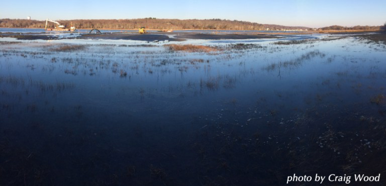
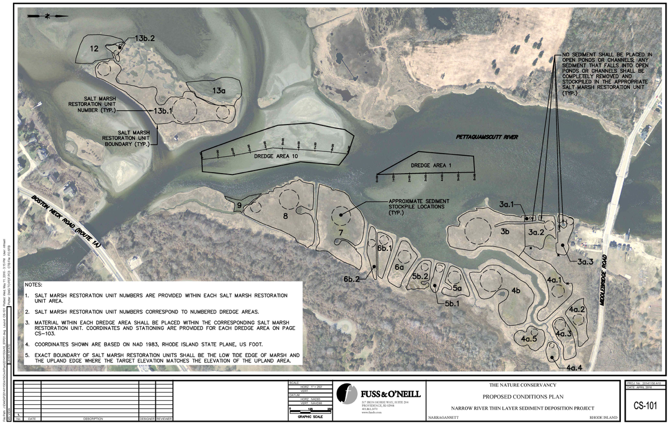
Material from the riverbed was excavated to deepen basins and the channel, as well as shift the channel back to its historical placement at the river’s center. A 1,300-foot tube attached to the dredge, transferred 24,000 yd3 of excavated material for thin-layer deposition. Overall, marsh height was increased by six to twelve inches, gradually increasing in elevation away from the shoreline. Shallow pools and pans were filled in with sediment, and runnels were formed in the marsh surface to enhance drainage.
How this project achieved a desirable species composition:
35,000 local plugs of S. patens and S. alterniflora were planted with the help of 200 volunteers.
How this project reestablished external exchanges with the surrounding landscape (e.g. migration, gene flow, hydrology):
Material was dredged from the Northeast and Southwest openings to Pettaquamscutt Cove to improve tidal flushing.
Activities were undertaken to address any socio-economic aspects of the project:
In order to alert boaters to the shift in the channel, buoys were placed along the channel’s edge.
Ecological Outcomes Achieved
Socio-Economic & Community Outcomes Achieved
Cultural dimensions such as recreational, aesthetic and/or spiritual:
The deeper channel is safer for boaters, as there is less incidence of boats hitting bottom and damaging their propellers.
Key Lessons Learned
During implementation of the project, restoration practitioners noted the value of working with SumCo Eco-Contracting, a full-service ecological contracting company based in New England that is specialized and highly-experienced in restoration work.
Long-Term Management
Long term monitoring will be necessary to track the marsh’s recovery so as to apply adaptive management as necessary. The new plantings will be monitored annually during the month of August. In addition, the groundwater will be tested every two months, and the net change in marsh elevation will be monitored yearly. USFWS will be responsible for the long-term management of the site.
Sources and Amounts of Funding
After Hurricane Sandy, the U.S. Department of the Interior through the Disaster Relief Appropriations Act of 2013 provided funding for a cooperative effort between the Nature Conservancy and the USFWS to improve saltmarsh resiliency in Rhode Island. A total of $1.4 thousand U.S. dollars was allocated towards the John H. Chafee Resiliency Restoration. Other support for the project includes the 200-strong volunteer force that aided in the saltmarsh planting.
Other Resources
- U.S. Fish and Wildlife Service Rhode Island National Wildlife Refuge Complex DRAFT ENVIRONMENTAL ASSESSMENT
- U.S. Fish and Wildlife Service Rhode Island National Wildlife Refuge Complex Draft Environmental Assessment APPENDICES
- U.S. Fish and Wildlife Hurricane Sandy Resilience and Recovery Projects
- John H. Chafee Wildlife Refuge Restoration Press Release
- John H. Chafee Thin-Layer Deposition Fact Sheet
Related Research
If you are interested in using the site in the study, please contact Dr. Jennifer White of the U.S. Fish and Wildlife Service (contact information below).Primary Contact
Name:
Jennifer White, Ph.D.
Affiliation:
U.S. Fish and Wildlife Service
State:
RI
Organizational Contact
Name:
Charles E. Vandemoer
Affiliation:
U.S. Fish and Wildlife Service
State:
RI