Overview
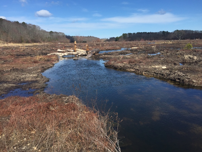
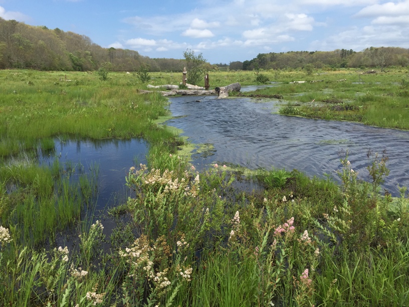
Prior to restoration activities, Tidmarsh Farms was a commercial cranberry farm in Plymouth Massachusetts. In 2010, approximately 200-acres of farmland was taken out of production on the east side of the property (Tidmarsh East) and placed under a conservation easement through the USDA NRCS Wetland Reserve Program. The owners, with the help of the Massachusetts Department of Ecological Restoration and other partners, completed assessment, design, and implementation phases over the next six years. The goal was to transform the site into self-sustaining freshwater wetlands and stream network through a “process-based” approach focusing on the movement and storage of water on the land. Restoration actions completed in 2016 included dam removals, stream reconstruction, ditch plugging, planting, and wood installations. Beaver Dam Brook is now open from its headwaters to Cape Cod Bay for the first time in over a century. Native plants and wildlife are returning to the site. The progress of this restoration will be monitored for decades by Living Observatory, a learning collaborative formed in parallel with the restoration project. Tidmarsh East was purchased by Mass Audubon and opened as a wildlife sanctuary in 2017, providing recreational and educational opportunities to the community. The western side of the farm was purchased by the Town of Plymouth and restoration is scheduled for 2019.
Quick Facts
Project Location:
Plymouth, Massachusetts, USA, 41.9584457, -70.66726210000002
Geographic Region:
North America
Country or Territory:
United States of America
Biome:
Freshwater
Ecosystem:
Freshwater Wetlands, Freshwater Rivers & Streams
Area being restored:
101.171 hectares
Project Lead:
Massachusetts Department of Fish and Game, Division of Ecological Restoration (DER)
Organization Type:
Governmental Body
Project Partners:
Tidmarsh Farms, Inc. (landowners), Massachusetts Division of Fish and Game (DFG), Division of Ecological Restoration (project manager), USDA Natural Resources Conservation Service (NRCS), U.S. Fish and Wildlife Service (USFWS), National Oceanic and Atmospheric Administration (NOAA), Massachusetts Environmental Trust, American Rivers, Gulf of Maine Council on the Marine Environment, Massachusetts Bays Programs, Town of Plymouth, MassWildlife, Living Observatory, Inter-Fluve, Inc. (project engineer), Sum Co Eco-Contracting (construction contractor), Mass Audubon, Manomet Center for Conservation Sciences, UMass Boston, UMass Amherst, MHC Restoration Ecology Program, MIT Media Lab, Salicicola, M.I.T., Boston University, Rising Tide Charter School
Location
Project Stage:
Monitoring & Evaluation
Start Date:
2010
End Date:
2016
Planning \ Design:
48
Implementation:
12
Post-Implementation Maintenance:
0
Monitoring & Evaluation:
240
Primary Causes of Degradation
Agriculture & Livestock, Dams & HydrologyDegradation Description
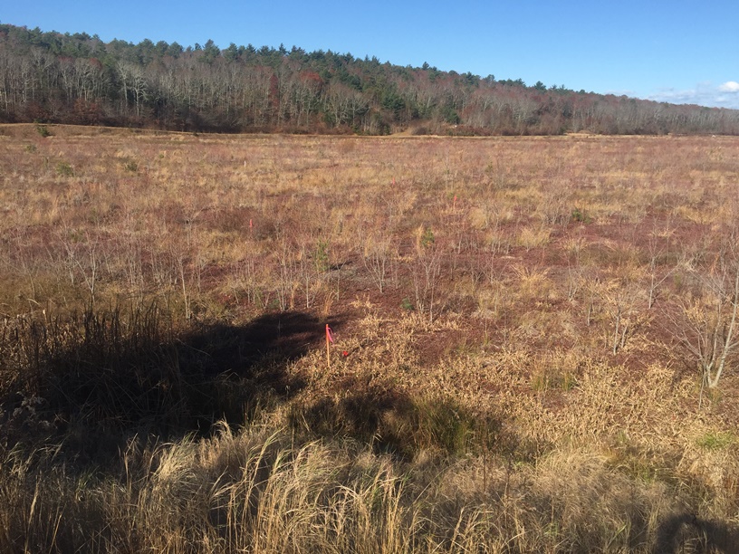
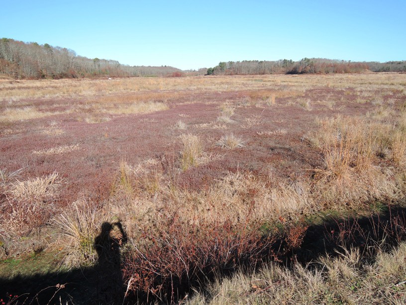
The land was purchased by the Manomet Cranberry Company in the 1890s, and has been used for agricultural production since then. Over the more than 100 years of cranberry farming on site, Beaver Dam Brook was altered by damming, ditching, and straightening. The former wetland surface was also altered significantly. After removal of native vegetation and grading to establish the original cranberry beds, a thin layer of sand was added every few years. After over a century of this common industry practice, several feet of compacted sand had accumulated over the native peat soils. The sand “fill” led to the separation of the ground surface from the water table, causing a gradual transition away from wetland plant communities. These combined practices led to significantly degraded wetland conditions on site, and these legacy impacts were targeted by the restoration project for active intervention to re-establish wetland hydrology on site. Additional impacts came from farming practices such as the use of fertilizers, herbicides, pesticides, and management for mono-culture. Upon cessation of farming in 2010, these practices came to an immediate end.
Defining the Reference Ecosystem
The reference ecosystem is based on diverse sources of information (e.g. multiple extant reference sites, field indicators, historical records, predictive data).Reference Ecosystem Description
This project focused on removing stressors and restoring processes that will create and maintain a self-sustaining wetland ecosystem. Although there was not a specific target wetland community in mind, the team gathered historical evidence and concluded that some form of forested swamp with deep kettle hole peat deposits was previously present. With an overarching goal of restoring hydrology that would support a self-sustaining wetland in the future, the project team did not hold any one vision of wetland development in mind. This gives the site flexibility to naturally heal over time, and be dynamic in response to future change. As project manager, Alex Hackman, stated, “The initial outcome is not the final product, but the beginning of the restoration trajectory”.
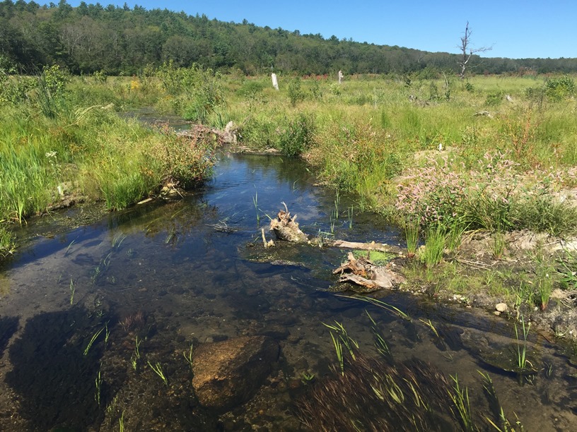
Historical maps show Beaver Dam Brook as a meandering freshwater stream that flowed northerly, to Bartlett Pond and emptied into Cape Cod Bay prior to the 1890s. This stream was important for the dispersal of wildlife, organic matter, and sediments. There are historical records documenting that Beaver Dam Brook and Fresh Pond (a natural 68-acre kettle pond on the site) formerly supported an anadromous fish run. The project already succeeded in restoring connectivity in the Beaver Dam Brook watershed. It has been returned to its original meandering path from its headwaters to Cape Cod Bay. Alewife (Alosa pseudoharengus), American eel (Anguilla rostrata) and blueback herring (Alosa aestivalis) have already been observed moving through the waterway.
Tree stumps and peat layers found in portions of the site, along with historic documents, suggest that sections of the site were once forested swamp. The downstream area of the current project site is mature red maple (Acer rubrum) swamp, an ecosystem common in headwater streams like Beaver Dam Brook, that are fed by springs or seeps. These swamps are usually dominated by red maple, but include other tree species, such as Atlantic white cedar (Chamaecyparis thyoides). Their dense shrub and herb layers provide important habitat for wildlife, such as understory birds and small mammals. Seasonal flooding provides breeding habitat for amphibians, and resting areas for migrating waterfowl. Forested wetlands provide many services such as flood protection, water purification, and groundwater recharge.
The Massachusetts NHESP mapped two areas of the project site as priority habitats for the Eastern Box Turtle (Terrapene carolina), a Massachusetts Species of Special Concern. The site is surrounded by forested uplands to the west and south, creating a buffer of 80 to 1,500 feet. This buffer is primarily composed of Eastern white pine (Pinus strobus), pitch pine (Pinus rigida), and oak (Quercus) species, and provides an important method of dispersal for wetland dependent species, such as turtles and amphibians. Actions that eliminated the steep and artificial transitions between the wetlands and uplands will facilitate the movement of these species.
Project Goals
This project sought to holistically restore an approximately 200-acre site from retired, degraded cranberry bogs to self-sustaining, high quality, freshwater wetlands and a cool-water stream network. This process based approach focused on removing limiting factors and regaining ecosystem function.
The primary objectives of the project were:
- to encourage the development of a self-sustaining, complex, productive, and dynamic (resilient) system of high-quality streams and native wetlands;
- to establish a refuge for diverse native plant and animal communities, including a restored herring run;
- to enhance connectivity, expand biological diversity, and promote conditions for self-sustaining wetland communities; and,
- to increase the connection between people and the land by providing a beautiful, protected area for public use and enjoyment.
Monitoring
Monitoring Details:
The Living Observatory plans to document the property’s recovery for 20 years or more.
Start date, including baseline data collection:
2010
End Date:
2030 or longer
Stakeholders
The landowners are extremely involved, as they initiated the project. They were involved in planning, implementation, and monitoring. One of the owners started Living Observatory, a learning collaborative formed in parallel with the restoration project, to monitor the progress of the restoration for decades to come. Although this was private land, the neighborhood had become adjusted to public uses, such as recreation, over many decades. Concerns about construction period impacts were raised. Several well-attended public meetings were held, and the project was closely followed in the local press.
How this project eliminated existing threats to the ecosystem:
When this site was taken out of production in 2010, many of the stressors caused by farming were eliminated such as the use of pesticides, herbicides and fertilizers, management for mono-culture, and active sanding of the bog surface. The project itself addressed the legacy impacts of agriculture that would have otherwise presented an on-going threat to wetland hydrology.
How this project reinstated appropriate physical conditions (e.g. hydrology, substrate)",:
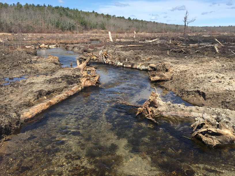
The project focused on re-naturalizing the movement and storage of water on the land, with an expectation that other physical processes would also be repaired (e.g. the movement and storage of sediment, organic matter, and organisms). Removal of the sand layer on site was not feasible, so a number of actions were implemented to help elevate the water table and increase soil moisture including:
• Filling perimeter irrigation ditches
• Plugging interior (lateral) irrigation ditches
• Reconstructing a sinuous stream channel with large wood (increasing hydrological residence time)
• Using two in-stream features (essentially constructed riffles) to slightly elevate upstream water elevations
• Mechanically breaking apart the dense cranberry mat to encourage the expression of springs on the restored wetland surface
How this project achieved a desirable species composition:
• Activation of native seed bank across the bog surface
• Supplemental planting to increase diversity (i.e., Atlantic white cedar trees, red maple, fen, grassland, transitional)
• Restore processes that drive formation of diverse plant communities
• Invasive species management
How this project reinstated structural diversity (e.g. strata, faunal food webs, spatial habitat diversity):
• Reconstructing main channel and tributaries
• Addition of large wood to channels and bog surfaces
• Creation of microtopography on bog surface
How this project recovered ecosystem functionality (e.g. nutrient cycling, plant-animal interactions, normal stressors):
All of the above
How this project reestablished external exchanges with the surrounding landscape (e.g. migration, gene flow, hydrology):
• Removal of dams to return drained impoundments to free-flowing streams (longitudinal reconnection)
• Removal of interior water control structures and agricultural-related berms
• Enlarge/replace culvert
• Slope perimeter to facilitate wetland to upland wildlife movement (lateral reconnection)
• Naturalization of upland-wetland transitions
Activities were undertaken to address any socio-economic aspects of the project:
• Retention of walking trails and an existing access route
• Bridge replacement to facilitate visitor circulation
• Mass Audubon purchased this site with plans to make it an educational and recreational resource to community
Ecological Outcomes Achieved
Eliminate existing threats to the ecosystem:
Contaminants from legacy pesticides are still present, but efforts were taken to minimize new exposure and uptake routes.
Reinstate appropriate physical conditions",:
• Increased soil moisture
• The area is now a functioning wetland
Achieve a desirable species composition:
• Native plants are reestablishing including little blue stem (Schizachyrium scoparium), wild indigo (Baptisia tinctoria), Juncus species, and sedges.
• Wetland bird species such as Sora (Porzana carolina), Marsh Wrens (Cistothorus palustris), and Swamp Sparrows (Melospiza georgiana) have been observed nesting on the property.
• Alewife (Alosa pseudoharengus), American eel (Anguilla rostrata), and blueback herring (Alosa aestivalis) have been observed moving through the waterway.
• There are still a number of invasive species colonizing, including reed canary grass (Phalaris arundinacea), Phragmites australis, black locust (Robinia pseudoacacia), autumn olive (Elaeagnus umbellate), and purple loosestrife (Lythrum salicaria) that will need continued management.
Reinstate structural diversity:
Microtopography, and large wood installations have added complexity to the land.
Recover ecosystem functionality:
Movement of organisms, water, sediment and organic matter has been reestablished.
Reestablish external exchanges with the surrounding landscape:
• Beaver Dam Brook has been opened from its headwaters to Cape Cod Bay for the first time in over 100 years.
• Alewife and blue herring have already been observed moving through the waterway.
Factors limiting recovery of the ecosystem:
The wetland portions of the site benefit from a protected forested buffer that keeps most development away from the restored areas. However, significant development pressure exists in the region, which could lead to future impacts.
Socio-Economic & Community Outcomes Achieved
Economic vitality and local livelihoods:
By converting out-of-service cranberry bogs to a wetlands preserve, the project will create a recreational resource that will attract visitors to the Town of Plymouth, which has the potential to improve the local economy. The Town of Plymouth Open Space and Recreation Plan (ORSP) noted that, “Cranberry growing has become less profitable in recent years and many growers are faced with difficult financial situations leading some to sell their land for development, or to mine their land for sand and gravel.” The proposed project is an example of a positive alternative for cranberry farm owners who need to convert their business.
Cultural dimensions such as recreational, aesthetic and/or spiritual:
One goal of the project was to increase the connection between people and the land by providing a beautiful, protected area for public use and enjoyment. This will be carried out when Mass Audubon reopens the site to the public as a wildlife sanctuary in late 2017. The property will be open for low impact outdoor recreation, and will eventually provide educational programming for the community.
Regulation of climate, floods, disease, erosion, water quality, etc.:
Forested wetlands provide many services such as flood protection, water purification and groundwater recharge.
Has the project had any negative consequences for surrounding communities or given rise to new socio-economic or political challenges?:
The site was temporarily closed for recreational use during implementation phase.
Key Lessons Learned
- A science-based framework, articulated up front, facilitates key early decisions and brings landowners and partners together.
- Simple visual tools help bring data together and develop alternatives.
- Keep things simple to communicate your design and intentions.
- Vigilance and collaboration help identify risks and opportunities in the field, and create conditions for rapid adaptation and adjustment.
Long-Term Management
Tidmarsh East is now owned by Mass Audubon. All of their wildlife sanctuaries are covered by an ecological management plan that “identifies the conservation assets provided by a sanctuary and prescribe actions necessary to maintain or enhance those assets in the face of 21st century challenges”. Being such a new property, they have not finalized a management plan for the Tidmarsh Wildlife Sanctuary. After speaking with the sanctuary director, Lauren Kras, it seems that follow-up years of native planting and invasive species management may be involved in this plan. This project was designed with the goal of the site self-healing over time with adaptive management. The western side of the farm was recently purchased by the Town of Plymouth for public open space. Also slated for future restoration, the Town is now working with DER, NRCS, Ducks Unlimited, and others on preliminary designs. Implementation on the west side is scheduled for approximately 2019. Living Observatory, created by owner Glorianna Davenport, is a learning collaborative of scientists, artists, and wetland restoration practitioners engaged in the documenting, interpreting, and revealing aspects of change as it occurs prior to, during, and following the Tidmarsh Farms Restoration Project.
Sources and Amounts of Funding
Over $3 million dollars; USDA’s Wetland Reserve Program, state, landowners, Mass Audubon, donations
Other Resources
- http://geo.salicicola.com/tidmarsh/
- http://www.livingobservatory.org/
- https://www.nytimes.com/2017/07/04/us/cranberry-bog-wetlands-restoration-climate-change.html?smid=pl-share
- http://www.habitat.noaa.gov/highlights/returningacranberrybogtoathrivingwetland.html?utm_medium=email&utm_source=govdelivery
- http://www.mass.gov/eea/docs/dfg/nhesp/natural-communities-facts/red-maple-swamp-fs.pdf
- https://www.des.nh.gov/organization/commissioner/pip/factsheets/cp/documents/cp-21.pdf
- http://plymouth.wickedlocal.com/news/20161122/everything-you-wanted-to-know-about-tidmarsh-farms
- https://www.massaudubon.org/get-outdoors/wildlife-sanctuaries/tidmarsh
Related Research
Ongoing research will be done through the Living Observatory.Primary Contact
Name:
Alex Hackman
Affiliation:
Division of Ecological Restoration, Massachusetts Dept. of Fish & Game
City:
Boston
State:
MA
Organizational Contact
Name:
Lauren Kras
Affiliation:
Mass Audubon Tidmarsh Farms Wildlife Sanctuary
City:
Plymouth
State:
MA
Email:
[email protected]