Overview
In 2003, the National Oceanic and Atmospheric Administration (NOAA), New York Department of Environmental Conservation, U.S. Fish and Wildlife Service, and the Town of North Hempstead restored a 0.8-acre salt marsh in Bar Beach Lagoon, North Hempstead, New York, as part of a natural resource damage assessment (NRDA) settlement addressing natural resource injury damages that had occurred as a result of the release of contaminants into Hempstead Harbor. Restoration activities included the removal of substantial volumes of fill consisting of sand, gravel, concrete and solid waste debris from the site, as well as the physical removal of approximately 0.2 acres of common reed (Phragmites australis). Each of the fill removal areas was excavated to sub-grade, backfilled with clean soils, and planted with native wetland and coastal upland plant species.
As part of the NRDA settlement, a 5-year monitoring program was implemented to assess the extent of success of the restoration project. Performance criteria were established and a reference marsh, located 600 feet to the northeast of the restoration site was selected. The reference marsh was also a fringing marsh and of similar size as the restoration site.
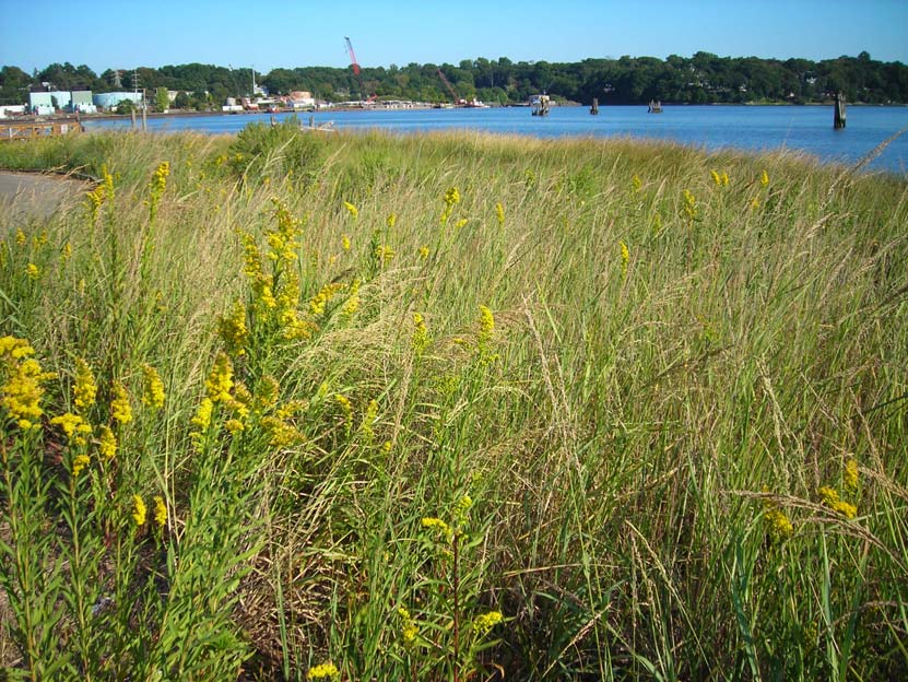
Monitoring results indicate that restoration performance has been successful in reestablishing a salt marsh community similar to the nearby reference marsh community. The planted salt marsh grasses are well established and flowering. The coastal shoreline zone in particular, had greater native marsh vegetation cover than in previous years. Fish, benthic, and avian communities at Bar Beach are comparable or trending toward those of the reference site, although it is recognized that marsh restoration may require multiple decades to achieve the full functionality of natural, unaltered wetlands. All of the performance criteria specifications had been met when monitoring was completed.
The information presented in this case study reproduces and draws heavily upon the restoration plan (Attachment 1) developed by the Trustees and monitoring reports produced by The Louis Berger Group through a NOAA contract task order.
Quick Facts
Geographic Region:
North America
Country or Territory:
United States of America
Biome:
Coastal/Marine
Ecosystem:
Estuaries, Marshes & Mangroves
Area being restored:
0.8 Acres
Project Lead:
National Oceanic and Atmospheric Administration (NOAA)
Organization Type:
Governmental Body
Project Partners:
National Oceanic and Atmospheric Administration (NOAA), New York Department of Environmental Conservation, U.S. Fish and Wildlife Service, the Town of North Hempstead, New York
Project Stage:
Completed
Start Date:
2003-05-27
End Date:
2008-05-27
Primary Causes of Degradation
Contamination (biological, chemical, physical or radiological)Degradation Description
The Applied Environmental Services (AES) Superfund Site is a 3.2 – acre site located at Glenwood Landing, Nassau County, New York, on part of a peninsula surrounded by the waters of Motts Cove and the eastern shore of Hempstead Harbor, a sub-estuary of Long Island Sound. Since 1939, numerous petrochemical operators had used the site for disposal. Beginning in 1974, part of the property was used for distribution and storage of chemical solvents. Between 1980 and 1983, a hazardous waste facility operated on the site. AES accepted many types of hazardous waste, including waste oil, chlorinated organic solvents, acids, paints, benzene, toluene, heavy metals and a variety of other organic chemical compounds. Shore Realty and New York State Department of Environmental Conservation (NYSDEC) performed a site cleanup during 1985 and 1986. Clean-up activities included removing hazardous waste stored in drums, containers and tanks contaminated with toluene, ethylbenzene, naphthalene, and polychlorinated biphenyls (PCBs). Subsequently, the site was designated as a federal Superfund site in 1986. In 1991, the U.S. Environmental Protection Agency (EPA) selected a remedy to directly address contaminants in the groundwater and soils of the site, thereby indirectly addressing contaminants migrating to the sediments, surface water, and air.
Releases of site-related hazardous substances were documented. Sampling demonstrated the presence of toxic levels of volatile organic compounds, semi-volatile organic compounds and metals in the aquatic environment. Bioassessment results indicated that leachate migrating from the site adversely impacted estuarine biota in Motts Cove and the Harbor. The greatest impact has occurred in the mudflats and saltmarsh adjacent to the AES Site on Hempstead Harbor. Approximately 2 to 3 acres of mudflat and saltmarsh cordgrass (Spartina alterniflora) were severely impacted as a result of site releases.
Bar Beach Lagoon lies 0.6 km northwest across Hempstead Harbor and was the location chosen for off-site restoration to compensate for natural resources and services that were lost or adversely affected by releases from the AES Superfund Site. The fringing wetland at this location had been degraded by urban filling, erosion, and invasive plant colonization.
Reference Ecosystem Description
This 5-acre tidal cove is located on the western shore of Hempstead Harbor, immediately east of West Shore Road in Port Washington, New York, and across the harbor from the Applied Environmental Services (AES) site. The project area consists of a mosaic of intertidal mudflat, sandflat, patchy low salt marsh dominated by smooth cordgrass (Spartina alterniflora), and shellfish beds dominated by ribbed mussel (Modiolus demissus) and eastern oyster (Crassostrea virginica).
The Hempstead Harbor mudflats and marshes provide important spawning, nursery and foraging areas for numerous aquatic species. Anadromous, catadromous, euryhaline and marine finfish and invertebrates use the Harbor and Motts Cove; some of these species have commercial and recreational value (NOAA, 1991). The importance of these waters to the aquatic community is demonstrated by the fact that they have been designated as Essential Marine Habitat for 15 species by the NOAA/National Marine Fisheries Service (NMFS, 2000).
Hampstead Harbor, along with the waters of Manhasset Bay and Little Neck Bay to the east and adjoining portions of Nassau County shoreline are significant habitat areas for wintering waterfowl and wading birds. This area supports an average of more than 10,000 scaup (a migratory waterfowl species), representing 26% of New York’s wintering population (National Audubon Society, 1998). The Harbor also supports significant numbers of canvasback, and American black duck, along with Canada goose, brant, common goldeneye, oldsquaw, bufflehead, red-breasted merganser, and American widgeon.
Project Goals
Restoration activities were deemed necessary as natural recovery to baseline conditions in Motts Cove and the Hempstead Harbor inlet adjacent to the AES Superfund site was not expected in the short-term, and possibly the long-term. This is because intertidal elevations in this area were not conducive to sustainability and survival of salt marsh vegetation that otherwise might naturally colonize available substrate.
The restoration project’s primary goal was to compensate for natural resources and services that were lost or adversely affected by releases from the site. Restoring the ecologically similar habitat at the site across the harbor from the injured wetland communities provided compensation for the loss of ecological services. The restored wetland has improved fish and shellfish habitat and detrital export function of this tidal community. It also attracts migratory birds including wading birds, shorebirds, waterfowl and passerines. These resources are similar to those injured at the site. In addition, the project has provided an opportunity for the public to enjoy this ecosystem due to its proximity to the Bar Beach Park and Hempstead Harbor Shoreline Trail.
Monitoring
The project does not have a monitoring plan.
Stakeholders
Under the provisions/authority of the Comprehensive Environmental Response, Compensation and Liability Act (CERCLA), the National Oceanic and Atmospheric Administration (NOAA) of the U.S. Department of Commerce, the U.S. Fish and Wildlife Service (USFWS) on behalf of the U.S. Department of the Interior (DOI), and the New York State Department of Environmental Conservation (NYSDEC) were designated as natural resource trustees. The Trustees act on behalf of the public to investigate releases of hazardous substances, establish liability, assess injury to natural resources, seek damages from responsible parties, and ensure that funds recovered from responsible parties are used soley to restore, replace, or acquire the equivalent of the injured natural resources. In August 1992, the State of New York, the United States, and the Performing Parties Group (the “PPG”which includes cooperating past and current owners, operators, and generators) entered into a Consent Judgment settling claims under CERCLA relating to the existence, release, or threat of release of hazardous substances at or from the site. Under this judgment, the PPG was required to perform remedial activities, pay natural resource damages and perform or fund restoration activities to settle their liability under CERCLA.
The Trustee negotiations with the PPG led to a settlement that funded restoration implementation and restoration monitoring to compensate for injuries to natural resources at the AES. The Trustees identified and evaluated a suite of restoration alternatives. Restoration plans were reviewed by experts from industry, agency restoration scientists, and interested members of the public. Offsite restoration of portions of a 5-acre salt marsh in Bar Beach Lagoon (across the harbor from AES) was chosen instead of salt marsh restoration adjacent to AES because it was deemed more sustainable than restoration adjacent to the site.
Decisions guiding restoration implementation and monitoring were developed as a part of a settlement agreement and subsequent modifications between the Trustees and responsible parties. The monitoring program was developed collaboratively by the Trustees.
Description of Project Activities:
Salt Marsh Restoration
This task involved removing pea gravel and other non-native fill material from a peninsula in the northwest corner of the tidal cove. An area of approximately 0.15 acres of low saltmarsh had been filled in this location. An average 3- to 3.5-foot excavation depth was needed to return this area to appropriate intertidal elevations capable of supporting the growth and colonization of planted smooth cordgrass and other native salt marsh vegetation.
A topographic survey tied into vertical benchmarks with known tidal datum was performed. More than 3,000 cubic yards of fill material was excavated using a backhoe and front end loader. Before beginning excavation a silt fence was installed at mean high water (MHW) to minimize sedimentation to the nearby marsh and saltflat. The peninsula was subgraded 6 inches and backfilled with clean plantable soils to avoid gravel or other debris in the final grade elevation. More than 6,000 low and high marsh plugs [smooth cordgrass (Spartina alterniflora), salt meadow grass (Spartina patens), and spike grass (Distichlis spicata)] were planted in the final graded area by local volunteers in 2003. An additional 2,000 plugs were planted in the high marsh and spring tide zones in 2004.
Coastal Shoreline Restoration
This task involved removing and regrading the northern shore of the tidal cove, which consisted of removal of concrete rubble, other solid waste debris, and fill historically placed in this location as part of the construction of the adjacent parking area for Bar Beach Park. The specific shoreline area addressed was approximately 400 feet long. Fill was removed and the coastal bank was regraded using clean soil and then stabilized with plantings of native wetland and coastal upland plant species.
The work involved excavating debris and regrading an area of approximately 0.25 acres. Silt fencing was properly installed at mean high water (MHW) before excavation began. A backhoe was used to complete the excavation, caution was exercised to prevent significant disturbance to the low saltmarsh community at and below MHW. Where possible, rubble was removed manually.
When debris/poor soils were encountered, these locations were subgraded to a maximum depth of 1 foot below final grade and backfilled with clean, plantable soils to the depicted final grades. Once the excavation and grading was complete, the coastal bank area was covered with jute mesh to minimize erosion. A rapid-germinating, salt-tolerant seed mix was applied to minimize potential erosion.
Once all grading was completed, shrubs, trees and emergent plants were installed to approximate a zoned coastal shoreline community. Native species and regional stock were used and included beach plum (Prunus maritima), groundsel tree (Baccharis halimofolia), high tide bush (Iva frutescens), switch grass (Panicum virgatum), and seaside goldenrod (Solidago sempervirens).
Invasive Plant Control
This task involved removing and controlling common reed (Phragmites australis), an invasive, undesirable species that dominated the western and southwestern portions of the tidal cove shoreline. This invasive plant had taken over the relatively narrow high marsh (irregularly flooded) zone within the tidal cove and varied from 10 to 50+ feet wide. Its colonization and growth was attributed to freshwater inputs (groundwater and surface runoff) from the upland slopes immediately adjacent to the marsh. Phragmites is generally intolerant of pore-water salinity levels greater than 20 parts per trillion (ppt), and is generally intolerant of regular flooding by full-salinity seawater.
The control of Phragmites at this site, within an area of approximately 0.2 acres, was accomplished through excavation activities that removed roots and rhizomes and lowered the substrate elevation, thereby decreasing the suitability of the addressed habitat for recolonization by Phragmites. Some manual removal was undertaken in subsequent years. These activities also increased natural colonization by desirable species and decreased the available seed stock and rhizomes of Phragmites extending into other restored areas of the Bar Beach Lagoon. A rapid-germinating seed mix was applied to upland disturbed areas to prevent erosion. More than 8,000 plugs of Spartina, other high- and low-marsh species, and upland species were planted after meeting the specifications for the final grading in 2003 and 2004.
Ecological Outcomes Achieved
Eliminate existing threats to the ecosystem:
Permanent shoreline transects and saltmarsh plots were chosen for assessments. Photographs of each area were taken at designated locations. Measurements were collected to assess the extent of plant survival and growth and improvement in marsh functions. The assessments included one reference location in the vicinity of the restoration project (Attachment 2). Specifically the components monitored were survival and growth of the salt marsh and shoreline plantings, physical stability of substrate, and surveys of macroinvertebrates, fish and birds using the marsh and stabilized shoreline. The performance criteria for the restoration project were: (1) 90% survival of Spartina alterniflora plantings after two full growing seasons; (2) 90% survival of planted shoreline vegetation after two full growing seasons; (3) 85% cover of the restoration area (marsh and stabilized coastal shoreline) within 5 years of initial planting; (4) minimal re-establishment of Phragmites australis and other undesirable invasive vegetation to 10% or less of the total restored area; and (5) species abundance, richness, and composition of macroinvertebrates, fish, and birds similar to (i.e. demonstrating strong positive trend toward or not significantly different from) reference marsh.
Monitoring results indicated that the restoration efforts have been successful in establishing a diverse population of salt marsh plant and animal species. The planted salt marsh grasses were well established and flowering. The coastal shoreline zone has a dense cover of native grasses and shrubs. Three years after initial planting, the restoration site met the 85% native species vegetative cover, 90% survival, and the <10% re-establishment of invasive plant species requirements. In year five, mean vegetative cover was 90.6% compared with 22.5% prior to restoration. Invasive species (Phragmites) cover approximately 1.0% of the restoration site area, as compared to 25% pre-restoration. The avian abundance, richness and diversity at the restoration site was higher than the nearby reference site although these conditions may reflect in part the configuration and location of the fringe marsh reference site and proximity to a public parking lot. Over the 5-year monitoring period, 49 bird species were recorded in the restoration area compared to 24 in the reference area. These differences were attributed to the difference in habitat surrounding the restoration and reference sites. The density, abundance, and diversity of the fish component of the nektonic community at the restoration site were slightly lower than that of the reference site, while grass shrimp abundance and density were higher at the restoration site. The macroinvertebrate community, dominated by ribbed mussels and mud snail was more diverse at the restoration site than the reference site, whereas species richness was the same for the two sites, and abundance was considerably lower at the restoration site than at the reference site. Lower abundance of macro-invertebrates in the restoration site was most likely due to mature substrate and the presence of well-established beds of ribbed mussels and higher densities of mud snails at the reference site.
Factors limiting recovery of the ecosystem:
The stipulations outlined in the performance criteria have been met by the restoration. Ecological recovery of the restoration site is on a trajectory towards the conditions measured and demonstrated at the reference site.
Socio-Economic & Community Outcomes Achieved
Economic vitality and local livelihoods:
The restored mudflats and marshes provide important spawning, nursery and foraging areas for numerous aquatic species some of which have commercial and recreational value. Both songbirds and waterbirds utilize the restoration site providing wildlife viewing opportunities. In addition, the project has provided an opportunity for the public to enjoy this ecosystem due to its location within the Bar Beach Park and close proximity to the Hempstead Harbor Shoreline Trail.
Key Lessons Learned
Additional plantings were needed to augment the initial plantings where mortality, erosion, and fill compaction occurred. Switch grass (Panicum virgatum) plugs were planted in the upland to address areas that did not respond well to initial seeding due to droughty banks soils. Herbivore-exclusion fencing was also erected to protect new plantings until they were well established and could withstand grazing. The town of Northhempstead applied glyphosate herbicide in 2008 to eradicate some recolonizing Phragmites and manually removed multiflora rose, Japanese knotweed, Norway maple, and common mugwort. They also installed more than 100 native shrubs and 1,500 grass plugs to further minimize the spread of invasive plants.
Long-Term Management
Control of non-native invasive plant species (e.g., mugwort, common reed, Japanese knotweed muliflora rose, porcelainberry, Norway maple) will need to be pursued aggressively on an annual basis or these species will most likely re-colonize and/or expand throughout the site.
Sources and Amounts of Funding
254,896+ USD PPG-Trustee NRDA settlement – ~$160,000; PPG funded design – $35,000 +; Town of North Hempstead Match (goods and services) – $32,584; Volunteer Match (labor) – $2,400; NOAA/NMFS/RC Community-Based Program Grant Award to North Hempstead – $24,912
Other Resources
–References–
National Audubon Society. 1998. Important Bird Areas in New York.
National Oceanic and Atmospheric Administration (NOAA). 1991. Preliminary Natural Resource Survey, Finding of Fact. Seattle: Hazardous Materials Response and Assessment Division, NOAA.
National Marine Fisheries Service (NMFS). 2000. Guide to Essential Fish Habitat Designations in the Northeastern United States.
The Louis Berger Group, Inc. and National Oceanic and Atmospheric Administration. 2011. Bar Beach Salt Marsh Restoration, Fifth Year Monitoring Report.
–Case Team Contacts–
Lisa Rosman
National Oceanic and Atmospheric Administration
Office of Response and Restoration
290 Broadway
New York, NY 10007
212.637.3259
Fax: 212.637.4206
[email protected]
James Turek
National Oceanic and Atmospheric Administration
Restoration Center
28 Tarzwell Drive
Narragansett, RI 02882
401.782.3338
Fax: 401.782.3201
[email protected]
Kathryn Jahn
U.S. Fish & Wildlife Service
New York Field Office (Region 5)
3817 Luker Road
Cortland, NY 13045
607.753.9334
Fax: 607.753.9699
Gwendolyn McCarthy
NOAA Office of General Counsel
55 Republic Drive
Gloucester, MA 01930
978.281.9297
Fax: 978.281.9111
–Links–
Case Documents associated with the Bar Beach Saltmarsh Restoration including consent judgment, restoration plan and monitoring reports can be found at http://www.darrp.noaa.gov/northeast/shorerealty/index.html
–Attachments–
Attachment 1-Restoration Plan
Attachment 2-Vicinity Map
Attachment 3- Photos of Restoration Activities and Results from NOAA