Overview
The Central Kalimantan Peatlands Project (CKPP) grew out of an increasing recognition at the local, national and international levels of the urgency of halting and reversing degradation of the peatswamp forests of Central Kalimantan, Indonesia. Drainage, illegal logging and fire have devastated the area’s peatswamps in recent decades, and the impacts on local livelihoods, the broader economy and critical wildlife habitats have been staggering. Moreover, the annual contribution to global greenhouse gas emissions has been massive, as the decomposing peat releases stored CO2 at an alarming rate. In response to the mounting crisis, the CKPP was developed as a large-scale restoration programme aimed at rehabilitating these vital ecosystems and safeguarding the region’s rich biodiversity. Implemented by a local five-member consortium, the project focused on damming drainage canals to restore natural hydrologic conditions, revegetating denuded areas with commercially-important native tree species, and taking steps to improve local socio-economic conditions while introducing sustainable agricultural techniques. The pilot phase completed in late 2008 provides a strong foundation for future conservation and restoration activities in Central Kalimantan and serves as a basis for other, similar activities in the rest of Indonesia and elsewhere in the tropics of Asia.
Quick Facts
Project Location:
-2.2736008, 113.9299795
Geographic Region:
Asia
Country or Territory:
Indonesia
Biome:
Tropical Forest, Freshwater
Ecosystem:
Freshwater Ponds & Lakes, Tropical Forest - Moist Broadleaf
Area being restored:
2 million hectares
Project Lead:
Central Kalimantan Peatlands Project
Organization Type:
Governmental Body
Project Partners:
Central Kalimantan Peatlands Project
Location
Project Stage:
Completed
Start Date:
2005-12-18
End Date:
2008-12-18
Primary Causes of Degradation
Agriculture & Livestock, Deforestation, Fragmentation, Mining & Resource Extraction, Urbanization, Transportation & IndustryDegradation Description
Unsustainable agricultural practices and logging activities pose a serious threat to the future existence of Central Kalimantan’s locally and globally important peatlands ecosystems. The region has suffered severely from forest fires and excessive drainage, largely resulting from the failed Ex-Mega Rice Project (EMRP), a government-sponsored rural development program that subjected 1.4 million hectares to intensive logging and systematic drainage.
Under the EMRP, about 4,400 km of drainage canals, some up to 10 metres deep, were excavated to lower the water table across vast areas of peatland forest and convert them for agricultural production. Once these canals began to fail (e.g. buildup of organic debris, collapsing banks), work on the drainage network ceased. However, the lattice of canals quickly proved destructive for habitat conservation and management efforts, as the drainage of EMRP peatlands has precipitated major, and largely irreversible, impacts over great distances, seriously compromising the ecological integrity of the entire region. The most direct impacts include:
Drainage canals have greatly affected surface water storage and flows, over large areas. The increased drainage has caused rapid desiccation and peat humification and has removed the characteristic hummock-hollow top layer that plays an important role in keeping peatlands wet in their natural state. This has prolonged the period when water tables are below the peat surface, which in turn has caused peat decomposition and subsidence. Downstream of the peatlands, the result of drainage can be increased peak runoffs and, thus, more flooding risk.
The impact of drainage is most severe in a zone of approximately 500 metres along the canals, where subsidence and possibly fire frequency are greater, resulting in relatively steep surface slopes away from canals. Peat surface elevations 1 km from canals are now generally 0.5 to 1 m higher than the canal sides. Instead of the original low-gradient peatland landscape that functioned as a single hydrological system over tens of square kilometres, a “mini-dome” topography has developed because of drainage. This now controls the hydrology of the area.
Not only did the lattice of canals lower the water table and dry organic soils, but it also provided improved access to what were once remote and largely inaccessible forests. Illegal logging operators took advantage of the new waterways to deforest areas near the canals and to excavate lesser channels radiating away from the canals in order to remove logs from even more interior locations. Moreover, the ranks of illegal loggers swelled, as thousands of settlers relocated under the EMRP soon found the acidic and infertile soils unsuitable for agriculture and turned to logging to supplement their income. These drained, logged areas became desiccated and fire prone, and are now the scene of devastating annual peat fires.
Fires in this peatland forest area can be triggered naturally through lightening strikes or by human interventions (e.g. discarded cigarettes, uncontrolled camp/cooking fires, clearance for agriculture). Fires in peatlands are devastating to the forest plant communities and structures, as well as the basic forest soils that sustain the vegetation. Unlike mineral soils in forests, organic soils are severely affected by fires, particularly when they are in a dry state. Of particular concern is the fact that fires in peatland forests can lead to massive carbon emissions, as happened in 1997 with the series of fires exacerbated by the El Niño-Southern Oscillation (ENSO) event. It is estimated that between 0.81 and 2.57 gigatonnes of carbon were released into the atmosphere as a result of burning peat and vegetation, an amount equivalent to 13-40% of mean annual global carbon emissions from fossil fuels. Many fire patterns in Indonesia are directly linked to the network of canals and ditches.
Reference Ecosystem Description
The morphology, soil conditions and hydrology of peat swamps are so closely interrelated that the slightest change in vegetation will have an immediate effect on the morphology and hydrology of the swamps, and any change in hydrology will change the vegetation.
This relationship can be observed in the vegetation zoning within a single peat dome. Nearest to rivers, lush forests receive abundant nutrients from river water and produce tall, productive trees. At the top of the peat dome, nutrients are scarce, as rain water is the only source. Thus, the forest has lower species diversity here, and trees are typically smaller (Pole forest), or occur only occasionally in stunted forms (“Padang”). Between these extremes are found mixed swamp forest types that are intermediate in the size, structure and diversity of trees. These vegetation patterns are reflected in the slopes, which are lowest on top and bottom, and in the peat type, which is least decomposed at the top of the dome and most decomposed lower down, near the rivers. As the peatlands have developed over several thousand years, these eco-hydrological zones have shifted to reflect internal and external changes. As the peat dome grows higher and wider above the floodplain with the continuing accumulation of dead organic material, a larger and larger area eventually sustains only a pole or “Padang” forest. Changes in river courses, peak river levels and rainfall also affect the development of the peat dome. As such, the peatlands are truly a dynamic and living landscape.
The Sebangau River catchment of Central Kalimantan, a blackwater river system that originates in, and drains, the last remaining large continuous area (13,000 km2) of dense peat swamp forest in Borneo, was the site of the restoration activities conducted under this project. The area is dominated by several peatland habitat types:
–Tall Interior Forest–
Found in areas with a peat depth of up to 12 metres, the tall interior forest has well stratified vegetation, with trees reaching a maximum height of approximately 45m, including Agathis, Koompassia, Shorea and Palaquium.
–Mixed Swamp Forest–
The mixed swamp forest is restricted to the Sebangau water catchment. It has layers of peat up to 6m deep with “peat islands” or hummocks that rise above the floodplain bisected by shallow drainage channels. Some of the hummocks are formed from decomposing tree-trunks, and are covered with tree seedlings and grassy vegetation. Most of the large sized hummocks are actually root plates of big trees. The soil surface on hummocks and hollows is covered with a continuous layer of leaves, which fall constantly from the trees. During the rainy season, the forest floor is largely waterlogged, as the hollows are filled with water that has risen above the soil surface. This accumulated water slowly streams from the interior towards the swamp edges. The mixed swamp forest is a stratified habitat that contains commercially valuable trees such as Gonystylus bancanus (ramin), Dactylocladus stenostachys (mentibu) and Cratoxylon glaucum (geronggang).
–Low Pole or “Padang” Forest–
This forest type occurs on the deepest peat and contains very few trees of commercial importance. The forest floor is undulating with large hummocks and deep depressions containing pools. Tree pneumatophores are a constant feature, and there is a dense root mat in the surface peat. Many trees show abnormal growth, often growing to a height of 9-12m before the leading shoots die. Because of the higher light levels penetrating the forest canopy and the high water table, there is a very dense growth of several Pandanus and Freycinetia spp. The most abundant pitcher plant in this forest type is Nepethes ampullaria, which forms dense carpets of pitchers on the ground, but also extends upwards into the middle canopy.
Peat swamp forests provide many upland and riparian habitats and have a unique atmosphere defined in large part by the sounds of many different animals. Sebangau National Park is home to 150 bird, 35 mammal and 36 fish species, and harbours about 10% of Kalimantan’s remaining Orangutan (Pongo pygmaeus wurnbii) population (6,000-9,000). Inventories in Ex-Mega Rice Project areas that still have vegetation coverage, including Block A north, have revealed the occurrence of at least 62 bird, 12 mammal and 6 reptile species.
In Block E (Mawas area), 63 mammal species have been recorded, including nine primate species. Two hundred eighteen bird species, 21 amphibians and 45 reptile species have been identified as well. In addition, there are at least 44 fish species, including such endemics as Tuka (Channa bankanensis) and Kapar (Belontia hasselti). There are also migratory white fish species, such as Saluang kahui (Rasbora cephalotaenia) and Banta (Osteohilus triporos).
Project Goals
The objective of the Central Kalimantan Peatlands Project was to maintain and restore peatlands in the Sebangau National Park area, Block E (Mawas) and other parts of the Ex-Mega Rice Project (EMRP) in order to improve biodiversity conservation over approximately two million hectares. In order to meet this objective, the project focused on improving the hydrology of the peatswamp forests and degraded peatlands, regreening degraded peatlands and reducing the incidence of and damage by fires.
Monitoring
The project does not have a monitoring plan.
Stakeholders
There is a clear linkage between peatland degradation and poverty, as the occurrence of peatlands in developing countries often coincides with rural poverty. Remaining wilderness areas and their natural resources provide a buffer for communities that are located far from markets and lacking in economic solvency. These communities often rely on the natural productivity of peatland ecosystems or make use of their potential by converting them for subsistence agriculture. The natural ecosystems enhance their food security, are important for the survival of their cultures and form the basis for their livelihoods. Consequently, effectively promoting the sustainable use and conservation of wetlands and their resources involves focusing on their value to local people. This means that the solutions to peatland degradation must put people first and must incorporate development and community-based action.
Central Kalimantan has become one of the poorest regions in Indonesia, largely because of peatland drainage and peat fire disasters. The area has suffered from a loss of resources, loss of development opportunities and increased risk for investors, all while it copes with difficulties in providing schooling and health services. Environmental degradation and poverty mutually reinforce each other, creating a vicious cycle that can only be addressed through a combined approach of development, peatland rehabilitation and conservation.
The CKPP partners have worked closely with local communities and authorities throughout the project to address these issues and solicit their expertise and experience in helping to resolve them. The design of specific planning activities and the mode of implementation were entirely bottom-up, being developed in collaboration with a Local Advisory Group chaired by the provincial Vice-Governor and assisted by an International Advisory Group formed to provide advice at the international level. Good cooperation with the local stakeholders has been a critical success factor, and this cooperation will also ensure the sustainability of the project’s activities beyond the end of the project.
Description of Project Activities:
CKPP worked in two main areas of Central Kalimantan: the Sebangau National Park area and the Ex-Mega Rice Project (EMRP) area, especially Block A north and Blocks B, C and E (Mawas). Within these areas, the activities focused on 25 villages in four districts (Katingan, Pulang Pisau, Kapuas and South Barito).
--Hydrology Restoration--
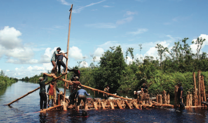
CKPP's hydrology restoration activities focused on Block A, North and East of the EMRP, and Sebangau National Park. Interventions to restore the hydrological systems involved the development of a technical design for dams, their construction and maintenance, and hydrological monitoring. Hydrological restoration was linked closely to regreening activities.
In the last decade, through similar work in Sumatra and Central Kalimantan, Wetlands International has developed and experimented with dam designs that can withstand enormous water pressure while standing in the very soft soils of peatlands. These types of dams were built in the project areas to block major drainage canals, some of them are over twenty metres wide. In the EMRP and Sebangau National Park, the consortium built 24 large dams and 263 small dams. More than 900 workers, divided into 39 groups, were involved in building these dams.
Information from field surveys formed the basis of the design and technical specification of the dams. CKPP used a design of winged blocks with a spill way. This design was based on the culmination of experience from previous designs. It was used in both blocking large canals (EMRP) and the smaller canals used for illegal logging. The main materials used were round timber (galam - Melaleuca sp), mineral soil in bags for filling the dam, and wooden boards and geotextile/tarpaulin to cover the spill way, which is there to reduce pressure on the dam. In this project, a new design feature was incoporated in which trees were planted on and behind the dams. Eventually, the dams should become redundant when vegetation and peat start to block the channel. The trees on the dam will then help to keep the soil inside the dam in place.
Dam construction involved three phases:
Pre-construction: This phase included group preparation and capacity development; mobilisation of manpower, equipment, and materials; and determination of the reference points of the dams.
Construction: Building materials were transported to the site in the wet season, which is also the best season to construct the dams. In this phase, the wood structure for the block was constructed, followed by filling the blocks with sandbags containing mineral soil and planting trees on the dams.
Post-construction: This involved demobilising the groups, equipment and camps.
After construction, maintenance of the dam is very important, especially in the first years. At a later stage, the canals will close and disappear as aquatic plants and trees start to add blockades. This process is very visible even within a few years of construction.
In order that the blocks remain functional, monthly monitoring and maintenance activities were conducted. A common issue that arose was the subsidence of the soil filling as it compacted. This was addressed by adding more soil bags. Another issue was the leaking of the blocks due to high water pressure, leaving the blocks vulnerable to structural damage. This was addressed by strengthening the wood structure. Damage also occurred from illegal loggers who continued using the canals to transport wood.
To monitor the effect of the dams on local hydrology, especially in Block A, North of the EMRP, instruments were installed in key locations. Forty-seven staff gauges were installed to monitor the surface water fluctuation, and 69 deep wells on nine transects served to monitor groundwater fluctuation. To complete the analysis of changes in hydrology, five manual instruments for measuring rainfall, one thermometer and three instruments to measure subsidence were also installed. Field staff collected data from these instruments twice a month, with relatively regular time intervals. In addition to hydrology monitoring, monitoring was also carried out on the impact of the dams on the surrounding wildlife. The results of identification and the preliminary qualitative conclusions indicate that the construction of the blocks had a positive effect on wildlife, especially in terms of improving animal mobility from one location to another and reducing the risk of fire. There were indications of both positive and negative impacts to aquatic life and further investigation of this is needed.
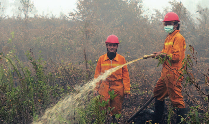
--Village Fire Brigades--
In 2006, CARE worked together with UNPAR to establish, train and equip 25 fire brigades (1 fire brigade per village). A total of 399 people (33 females and 366 males) were members of the brigades. The capacity of fire brigades to extinguish fires increased from the rate of 0.173 ha/hour in September 2006 (measured at the first training) up to an average rate of 1.75 ha/hour in November 2006 (during their first attempts to extinguish fires). CARE was responsible for activating all the brigades in Katingan and Pulang Pisau districts; BOSF did the same in Kapuas and Barito Selatan Districts.
Villagers were also trained in the development of deep wells to provide water for both fire fighting and other uses during the dry season. A total of 50 wells were developed in the Block E area, 75 units along the Trans-Kalimantan Highway, and others in the villages in the buffer zone of Sebangau National Park.
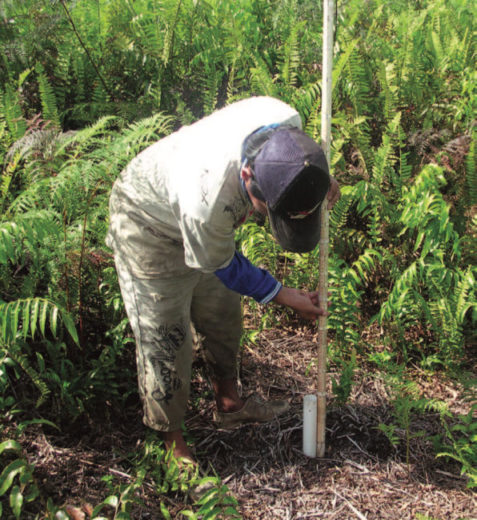
--Regreening--
Regreening is a crucial element in restoring the peatlands. Vegetation cover protects the peat against direct sunlight, creates a wet microclimate at the soil level, stores water, and reduces surface waterflow. Roots keep the peat in place and also help in storing and maintaining water.
For regreening, the project used only native forest species, mostly those with a commercial value such as jelutong (rubber for chewing gum) and belangiran (a tree precious for its meranti wood). Other tree species planted included: Gerunggang, Jambu-jambuan, Pulau rawa, Pasir-pasir and Tumih. Planting of species that will eventually have a commercial value is crucial for success, as local people are more likely to see the benefit of rewetting the area and will be motivated to prevent and control fires. In some areas, species with value as food for Orangutan were replanted in an effort to help this threatened species survive.
The regreening program in Block E can serve as an example of how regreening should be carried out. The following steps were taken:
1. Formation of community regreening groups with responsibility for the development of nurseries to raise seedlings. Target communities included those living in areas considered critical for conservation purposes.
2. Training the groups to ensure good growth levels during the seedling and planting stages.
3. The development of community-based nursery units to provide seedlings. Seedlings were obtained through stem-cutting, wildlings and fruits. To create ownership by local communities, commercial species were selected.
4. Planting of the seedlings when they are robust enough. Often, the cover of ferns has to be removed first.
5. Maintenance during the first and sometimes second year and monitoring of tree growth.
The potential area for regreening is enormous; the entire rewetted area (around 60,000 hectares) is suitable. Regreening is, however, a very labour intensive activity; therefore, a matrix was employed to prioritize areas for regreening based on the level of critical land and management zonation. The first priority was critical or barren lands (i.e. open land with bushes) resulting from fire and illegal logging, as well as degraded lands resulting from abandoned farmland, plantations or other community usage due to changes in agricultural patterns or community livelihood (burning, illegal logging, farmland clearing, plantation, etc.).
--Monitoring and Law Enforcement--
In order to reduce illegal logging activities inside the National Park, a series of 34 joint patrols were facilitated, involving National Park authorities, representatives of local communities and NGOs. These regular patrols resulted in reports to, and actions by, the authorities and a subsequent decrease of sawmill operations in Katingan District. A clear indication of this has been a significant decrease in log supplies. In 2006, there were 147 sawmills in Katingan Regency, 102 of which were still operating. This number had been reduced to two by the end of 2008.
Data shows that during an anti-illegal logging campaign in June 2006, a total of 1,078,360 logs, equal to 134,795 m3, were confiscated. Most of the logs originated from Sebangau National Park and were being transported through the Bulan River and Tampelas village.
In the Block E area (Mawas), monitoring was conducted by means of air, land, and river patrols. The purpose was to detect both illegal activities and fires within and around the area. During the project, 27 air patrols were carried out using ultra-light aircraft; 342 river patrols were carried out using small motorised boats; and 393 land patrols were carried out. Monitoring was also conducted every 35 days in order to determine changes in land cover. Cases of significant change (such as deforestation, damage from fire, road construction, etc.) were followed with field checks using ultra-light aircraft and navigation cameras.
--Community-based Agro-forestry--
CKPP prioritised improving the welfare of communities in the peatlands. This was a crucial element of the project, as restoration and sustainable local livelihoods are strongly inter-dependent. Poor people often have no alternative other than illegal logging or clearing rainforest areas by slash and burn. The resultant degradation worsens floods, fires, and soil subsidence, all of which exacerbate conditions of poverty. CKPP prioritised involving local communities in finding a balance between the production and environmental functions in the peatland ecosystem in order to stop this downward spiral.
The implementation of community-based agro-forestry systems (combining trees of commercial value with crops) was closely linked to regreening programmes, especially in Blocks E and A-north. From historical data on the biophysical degradation of the areas, the project was able to identify the native tree species that were appropriate for each degraded land area. A manual was subsequently produced on the development and management of strategic buffer zones, through the planting of indigenous but commercially important tree species under community-management regimes.
Farmers were encouraged to adapt their practices to take into account (and improve) the degraded natural environment. Improving the quality of the environment is a key to increasing agricultural production. In recognition of this, stakeholders' workshops were held to identify appropriate and sustainable agricultural technologies and practices. The workshops organised by CKPP, farmers, NGOs, government officials, state research institutions and academics discussed agricultural practices that have a minimal negative impact and/or a positive impact on the environment, focusing on the sub-sectors of food crops, plantations, livestock and fisheries. The outcome of these workshops was a set of standards (PEAT-GAP) identifying good agricultural practices for peatlands within each agricultural sub-sector.
At first, communities thought that sustainable agriculture would only inhibit production, but by the end of the project this perception had changed. Some 3,540 households (828 female household heads and 2,712 male household heads) in 25 villages have adopted PEAT-GAP technology and sustainable agriculture practices that are adapted to local conditions and specified standards. In addition, farmers were encouraged to try sustainable practices and let others imitate what they have done successfully.
The project also sought to improve access to markets, with farmers' groups playing an active role in this activity. CKPP prioritised local production for local consumption, a model intended to create more equal profit sharing along the marketing chain in villages and sub-districts. The profit obtained by farmers is optimised as there are no transportation costs, which are typically borne by farmers when they sell their products to intermediaries. A lower selling price enables the poorer members of the community, with limited buying power, to reduce their expenses.
CKPP facilitated the establishment of 11 partnerships and opened access to markets for 1,094 farming households, covering 36.5% of the target population (48 females and 1,046 males). Farmers were encouraged to grow crops that are usually widely sold in the local markets yet supplied from other areas. By maintaining quality, quantity and regular supplies, farmers were able to become the main supplier of these commodities to local markets.
Ecological Outcomes Achieved
Eliminate existing threats to the ecosystem:
In Central Kalimantan, the project, together with local communities, built 24 dams in large drainage canals and over 150 blocks in small drainage channels, restoring the hydrology of 10,000 ha in the Sebangau area and over 50,000 ha of drained and degraded peatlands in the EMRP area. These interventions increased the water table by one, and often two, metres, greatly reducing peat decomposition and subsidence.
Rewetting the areas made these peatlands far less fire-prone, and those fires that did occur were more rapidly detected and controlled by the teams of firefighters. Around 250,000 ha of peatland now have improved security from fires, and fire-fighting capacity has been improved in 25 villages.
The project has reforested over 1,000 ha of peatlands. Two years after replanting, some tree seedlings are already a few metres high.
Farmers were persuaded to plant seedlings of valuable indigenous tree species that can live in waterlogged conditions in order to discourage drainage of the peatlands. These commercial crops will help increase local communities' standard of living and will afford them options other than draining and deforesting peatlands.
The project activities enhanced the status of the Sebangau National Park and of Block E by restricting illegal logging and providing alternatives for local residents. This enhanced protection was also achieved through the participation of local communities in defining the park boundaries and other aspects of planning biodiversity conservation. This helps to improve the long-term conservation of threatened species such as the Orangutan, especially through securing large areas of their peatswamp forest habitat.
Factors limiting recovery of the ecosystem:
The CKPP experienced constraints and weaknesses, including weak communication networks and limited capacity, synergy and integration of activities among parties involved in implementation. Externally, it is recognised that there was the potential for coordination and facilitation through the Provincial Programme Coordination Team (PPCT), but the effectiveness of this mechanism was not optimised. These issues should be addressed in any follow-up initiative involving CKPP or any similar programmes that may be developed in the future.
Not only were administrative/institutional challenges encountered, much skepticism and resistance was initially met from local community members. Peatswamp forests are valued by most local communities for many reasons, not just the timber and non-timber products that they provide. Currently 70% of the income of households living in this region comes from farming and forestry, and some 57% of households farm solely for subsistence purposes. Therefore, any change that affects agriculture, such as blocking canals or restricting the use of fire, is critically viewed. This finding implies that the provision of alternative sources of income and food is a crucial aspect in convincing farmers to switch to more sustainable practices.
Socio-Economic & Community Outcomes Achieved
Economic vitality and local livelihoods:
--Hydrology--
Peatlands are valuable for flood and flow regulation. They can serve as overflow or water storage areas during flooding periods, while in the dry season water is slowly released. They are also important for preventing salt water intrusion. Agriculture in tidal areas may benefit from upstream peatswamps which provide a source of fresh water for irrigation and a continuous freshwater wedge, preventing or mitigating salt water intrusion. In rural coastal areas, peatswamps may be the only source of potable and irrigation water for many months in the year.
--Climate Stabilisation--
Peatswamps are huge carbon storage areas. The carbon stored in peat represents 33% of the world's soil carbon pool, which in turn represents 70% of all carbon stored in biotic systems. Almost 20 times more carbon is stored underground as peat than above the ground in vegetation. Furthermore, healthy tropical peatswamp forests actively accumulate carbon, thus helping to decrease the greenhouse effect. It is estimated that for every hectare of peat that is rewetted, annual emissions of peat-carbon are reduced on the order of around 70 tonnes of CO2. In total, the reduction of decomposition alone (through rewetting) accounts for a reduction of approximately four million tonnes of CO2 per year.
The existence of peatswamp forests and the associated large mass of fresh water also affects the climate on micro and meso scales. The forests act as wind breaks and absorb heat, and forested lowlands attract more rain than deforested areas.
--Local Livelihoods--
The livelihoods of the local people in Central Kalimantan are largely dependant on the natural peatswamp forests and surrounding peatlands, which comprise the main habitat in the province and project area. Socio-economic studies in Indonesia indicate that local communities may derive over 80% of their livelihoods from the peatswamp forests rather than from agriculture. The forests serve as hydrological buffers, transport corridors (e.g. peatland rivers and canals) and a source of food (e.g. fish), water (e.g. for irrigation, households and nature), construction materials (e.g. timber, rattan), as well as many other (non-timber) forest products. In addition, the peatswamp forests provide options for additional developments, such as tourism.
--Cultural Identity--
Many of the amenities, functions and values of the peatlands are crucial, not only for the environmental and food security of these people, but also for the survival of their cultures and as a basis for their livelihoods. Indeed, the natural products and wildlife of peatswamp forests play a substantial role in the identity of the Dayak culture in Kalimantan.
Key Lessons Learned
The CKPP consortium has been successful in raising both local and global awareness of the problems facing peatlands in Indonesia and of their international importance as significant carbon sequesterors and climate-change mitigators. Within Indonesia, there appears to be renewed respect for peatswamps and for the environment in general. This changing perception can be noted in the reduction of illegal sawmills around forest reserves and in the increased political, public and financial support for peatland conservation. Indeed, the Provincial Government of Central Kalimantan has initiated the development of a Master Plan for Peatlands rehabilitation, and in 2007, the National Government issued Presidential Instruction No 2/2007 regarding the rehabilitation of the Ex-Mega Rice Project area.
Thanks to media coverage and consortium members’ presence at key meetings, global awareness about Indonesia’s peatlands ecosystems has also been raised. The relationship between peatlands and global climate change is now more widely recognised by the UN Convention on Climate Change (including REDD, the UN climate policy on Reducing Emissions from Deforestation and Degradation in developing countries), the Convention on Biological Diversity and the Ramsar Convention on Wetlands. All of these bodies made decisions in 2007 and 2008 that address tropical peatlands as a key ecosystem with high values for carbon storage.
Long-Term Management
The CKPP is a first step towards the restoration and sustainable use of peatlands in Central Kalimantan and throughout Indonesia. The successes of the project set an important example, but are still relatively minor in comparison to the scale and intensity of problems and challenges of peatland exploitation in the area. There is a clear need for replication and expansion of restoration activities over a broader geographic context, and completion of the Master Plan for over one million hectares of the EMRP will be the next step in stimulating the long process of rehabilitation and revitalisation of the troubled area.
The CKPP brokered a deal between the Government of the Netherlands and Indonesia to develop this Master Plan. The contents of the document are still relatively general, underlining policy issues and providing guidance, and it will undoubtedly be discussed, reviewed and revised in accordance with developments over time, improvements in the science base, and changes in national and international policy frameworks and in the local situation. Nonetheless, the following recommendations have been made to orient future peatlands management activities both in Central Kalimantan and beyond:
–The results of the Master Plan in relation to structure, management and use of the EMRP area should be integrated and synchronised with the ongoing revision of the spatial plan of Central Kalimantan Province. This will provide the Master Plan with increased legal authority.
–Strategies and detailed action plans should be developed for sectoral and inter-sectoral peatland management (conservation, agriculture, transmigration, forestry, fisheries, health, tourism, etc.). Institutional structures need to be developed and enhanced to effectively and economically implement this management system.
–The pilot activities implemented by CKPP remain relevant and in line with the needs and priorities of Central Kalimantan. Further diversification will be useful, particularly with regard to emerging opportunities such as REDD, Bio-rights, biodiversity offset mechanisms and payment for environmental services.
–Project monitoring should be improved, and involve developing a detailed monitoring protocol, regular independent monitoring and evaluation of approaches, field activities and outcomes, as well as establishment of specific monitoring systems for defining and measuring impacts. Regular project monitoring should be implemented by task groups under the Scientific and Technical Advisory Committee, augmented by annual independent monitoring and evaluation surveys.
–A REDD methodology for reducing peat degradation related to emissions should be developed in the context of international developments in this regard. Local capacity should be developed for REDD methodology implementation, especially the monitoring of emissions and water levels in line with scientific and market requirements.
–The CKPP Board should include representatives of other major peatland projects to ensure coordination among donors, optimise synergies, avoid duplication and overlap and ensure that project plans relate appropriately to the local absorption capacity.
–The CKPP Board should ensure the longevity of financial mechanisms to enhance the security for local stakeholders. One of the key difficulties in resolving the unsustainable land use issues in Indonesia’s peatlands is the lack of sustainable finance mechanisms and coherent finance strategies to support an integrated approach to poverty reduction, environmental management and biodiversity conservation. In the follow-up to the Bali roadmap, and also as a result of CKPP and Master Planning, bilateral donors are now paying much more attention to peatland issues in Central Kalimantan. This was not the case at the beginning of the project. However, the high interest in this particular area also carries the danger of exceeding the absorption capacity, and there is an increased need for donor coordination. Moreover, current project-by-project funding does not provide the financial security needed for local stakeholders to change their livelihood and investment strategies. There is a clear need for guarantees of a long-term sustainable funding flow that will enable the longer-term investment strategies that are essential for achieving conservation and sustainable development. The potential of innovative mechanisms such as voluntary carbon markets, REDD funding, Payments for Environmental Services, Bio-rights and Bio-diversity offsets, offer great potential for supporting government-led as well as community-based approaches to enhancing the sustainable management and conservation of these critical carbon stores and high biodiversity areas. There is now a need for international and local systems for managing funding flows in a way that guarantees accountability and transparency requirements and can ensure the equitable allocation of carbon rights and carbon funding, empowers local stakeholders and achieves maximum participation of the poor. None of these mechanisms exist at present. Yet these will be needed for gaining the necessary support of the local communities. With the emergence of a broadly shared understanding of the need for these innovative systems, and a global awareness of joint synergistic targets (e.g. climate change mitigation, biodiversity conservation and poverty reduction), there is a window of opportunity that has not existed before. Indonesia, and the peatlands of Central Kalimantan in particular, can provide an excellent basis for developing, testing and promoting these.
Sources and Amounts of Funding
The project was financially supported by The Ministry of Foreign Affairs of the Netherlands (DGIS).
Other Resources
Wetlands International
http://www.ckpp.org/
http://www.wetlands.org/WatchRead/Videos/CentralKalimantanPeatlandProjectCKPP/tabid/1412/Default.aspx
WWF
http://www.panda.org/about_wwf/where_we_work/asia_pacific/where/indonesia/wwf_indonesia_conservation/projects/index.cfm?uProjectID=ID0199