Overview
In 1999, work began on 19 km of the Provo River in the Heber Valley to clean-up, and otherwise restore, the habitat and ecological functions of the middle Provo River. This $45 million effort, called the Provo River Restoration Project (PRRP), has now been completed, and the reconfigured channel is among the most heavily fished streams in Utah. Fish and wildlife, including an endangered species, have thrived following restoration efforts. This project is a nationally recognized effort. No other stream in northern Utah has been the subject of such an intense clean up and restoration activity, yet many streams are in as degraded a condition as the Provo once was. Today, the PRRP is viewed as a model for restoration elsewhere in the state.
Quick Facts
Project Location:
Provo River, Utah, 40.4616456, -111.32029740000002
Geographic Region:
North America
Country or Territory:
United States of America
Biome:
Freshwater
Ecosystem:
Freshwater Rivers & Streams
Area being restored:
19 kilometers
Organization Type:
Governmental Body
Location
Project Stage:
Completed
Start Date:
1992-01-15
End Date:
2008-01-15
Primary Causes of Degradation
OtherDegradation Description
The first permanent settlements in the region were established by the Mormon pioneers who arrived in Utah in 1847. A settlement along the Provo River was established in 1849 and water from the river began to be diverted for agricultural irrigation. Thereafter, more farms were established and the population began to grow. Soon water from the Provo River was diverted to other communities. A small fisheries industry developed on the Provo River and at Utah Lake and its tributaries. In the late 1860s and through the 1870s, commercial fishing waned as more water was diverted for agriculture and the amount of fish declined. Thereafter fishing continued in the Provo River with limitations. Today fishing on the Provo River is almost entirely recreational. Population growth and economic development increased demand for water for agricultural irrigation, domestic use, and industrial use. The populations of the cities that use Provo River water exhibited slow growth followed by increased growth after the introduction of the railroad in 1873. The number of cities that use Provo River water has also grown. Local use of the Provo River water continues, but Salt Lake County and other northern communities now also use the water. As regional economies developed and changed, Provo River water was required for different uses. The construction of Geneva Steel in Orem and other manufacturing operations in the 1940s placed a greater demand on Provo River water for industrial use (Donaldson 2005).
In the 1940s, the Provo River Project began, which has diverted, stored, and delivered large quantities of water from numerous Utah watersheds to help meet the needs of central Utah’s citizens. As part of the Provo River Project, the middle Provo has received additional water from trans-mountain diversions from the Weber and Duchesne Rivers on the south slope of the Uinta mountains. To accommodate the high flows resulting from this diverted water, the middle Provo River was channelized and confined between dikes. As a result of this channel alteration, the complex middle Provo River ecosystem, in which fish and wildlife thrived, was lost. In the early 1990s, the Jordanelle Dam was constructed on the Provo River for storage as a feature of the Central Utah Project (WFHI 2007). Residential growth has also increased demand for water for domestic uses, including lawn and garden care. Water from the Provo River is currently used for recreation, agricultural irrigation, culinary water, and power generation. The Provo River is a popular fishing stream. Floating the river is also a popular activity. The Provo River currently provides drinking water for 50 percent of the population of the state of Utah (Donaldson 2005).
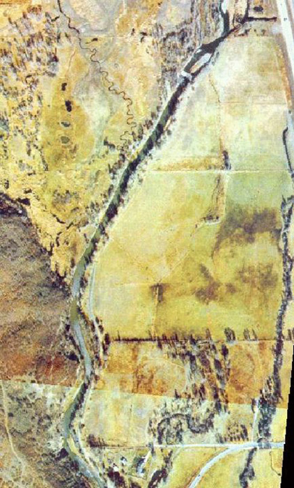
The Middle Provo was significantly impacted by the construction of the two dams that define its boundaries, and by subsequent flood control and irrigation projects. The Middle Provo is that segment of the Provo River that lies between the Jordanelle Reservoir and the Deer Creek Reservoir. Below Deer Creek, the river flows to Utah Lake, which is southeast of the Great Salt Lake in Utah.
Reference Ecosystem Description
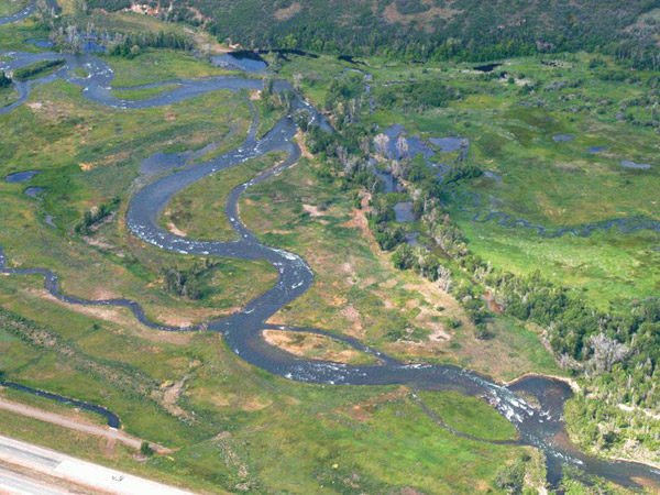
Prior to the 1940s, the middle Provo River meandered freely through the Heber Valley, offering outstanding fish and wildlife habitat. The bends in the river provided deep holes for fish and a dense streamside forest for many species of birds (URMCC 2008).
Project Goals
The Provo River Restoration Project (PRRP) is simple in its objective: to create a more naturally functioning river system for the middle Provo River between Jordanelle Dam and Deer Creek Reservoir (URMCC). The project aims to accomplish its restoration mission by focusing on the restoration of natural fluvial processes.
Monitoring
The project does not have a monitoring plan.
Stakeholders
The Utah Reclamation Mitigation and Conservation Commission (URMCC) is federally mandated to assure that mitigation for federal reclamation projects in Utah are accomplished. The URMCC is responsible for implementing the Provo River Restoration Project (PRRP) (URMCC 2008). The PRRP is also being undertaken under the general authority of the Secretary of the Interior to manage and correct problems arising from federal reclamation projects.
When the U.S. Bureau of Reclamation built Jordanelle Dam they were required to acquire 135 acres of private property along the middle Provo River to help provide a public access corridor downstream of the Dam. The U.S. Bureau of Reclamation (BOR) and The Nature Conservancy are cooperators in the acquisition effort (URMCC 2008).
The PRRP has been planned among government agencies, outdoor groups, biologists, local officials and the general public over the last ten years.
Description of Project Activities:
Prior to 1992 it was suggested that structures be added to the middle Provo River to create pools and other habitat for fish as a mitigation measure. This resulted in one of the three alternatives: the Instream Structures Alternative. The URMCC expanded upon this obligation in order to meet its "ecosystem restoration" standard and developed the Proposed Action (soon to be accepted), which included returning the middle Provo River to a more naturally functioning condition in order to support additional aquatic species and restoration of wildlife habitat, which more fully responds to the need for mitigating impacts on riparian habitats inundated by Jordanelle Reservoir. The Existing Channel Modification Alternative exists between the aforementioned Proposed Action and Instream Structures alternatives in its ecosystem design. The Proposed Action, also known as the Riverine Habitat Restoration action was soon approved. It was the design incorporating the most complexity in adding additional channel features as well as meanders, backwater areas and side channels and a broader floodplain. In addition this design seeks to maintain a river system over time that will provide wildlife habitat without the need for extensive human intervention (URMCC 1997). One of the biggest challenges faced in the restoration design of the middle Provo River was the altered hydrologic regime placed on the river by the Jordanelle Dam and prior imported water patterns. Because the dam placed artificial demands and controls on the middle Provo River ecosystem, it could not be restored to its pre-disturbance condition. Therefore, the restoration design approach focused on the goal of reestablishing the important physical and biological processes that would sustain the ecosystem under this new hydrologic regime (WFHI 2008).
The following provides a summary description and key characteristics of the chosen plan of action for the Provo River Restoration Project (PRRP) (URMCC 1997):
Summary Description of Plan of Action - Riverine Habitat Restoration - PRRP
- Reconstructs and realigns most of the existing river channel and floodplain system in a meandering riffle-pool sequence (where there are alternating shallow and fast and deeper and slower sections of water).
- Removes existing levees; however, 100-year flood protection would still be provided by the expanded floodplain or new setback levees. The new floodplain would be subject to flooding once every 2 years and once every 5 years with velocities capable of scouring surface soils- these conditions are necessary for natural regeneration of cottonwood trees and other riparian vegetation.
- Allows the river to flood onto the expanded floodplain and to alter its course (the river channel may widen or move across the floodplain in response to natural forces similarly to how it functioned before channelization).
- Revegetates disturbed areas along the new floodplain with indigenous plants.
- Constructs side channels and ponds on both sides of the new river alignment. These would create diverse habitat conditions for spawning and rearing of fishes, especially non-game fishes and other aquatic or amphibious species.
The following was to be implemented whether a plan of action had been approved or not.
- Providing seven new recreation access points along the Provo River between Jordanelle Dam and Deer Creek Reservoir including parking and restroom facilities;
- Providing pedestrian access for fishing and related or compatible uses along the Provo River between Jordanelle Dam and Deer Creek Reservoir;
- Fencing of the public access corridor to control trespass problems;
- Managing the acquired corridor and constructed access facilities through a management agreement with a state or local entity;
- Maintaining a minimum instream flow of 125 cfs in the Provo River below Jordanelle Dam.
Key Characteristics of Plan of Action - Riverine Habitat Restoration - PRRP
Main Channel Activities
- Construct 70-100 ft wide (typical) meandering riffle-pool channel.
- Remove or breach nearly all dikes; establish 400+ ft wide floodplain.
- Regrade channel profile to fit natural features.
- Restore 11.6 miles of river.
- Remove 47,800 ft of existing levee.
- Increase existing river length by 9,430 feet.
Floodplain Activities
- Construct 50,070 ft of side channels (19,340 feet in Core Area, 30,730 feet in Expanded Restoration Area);
- Construct five to ten floodplain ponds (12.6 acres, including construction of eight Spotted Frog habitat ponds);
- Raise or lower 47 acres to develop needed channel-floodplain.
Channel Stability
- Excellent dynamic stability conditions because of adherence to geomorphic design for riffle-pool channels.
- Riffles designed to hold grade.
- Additional bank protection used where necessary.
Flood Control
- If only Core Area is acquired, construct 22,100 ft of 2 ft to 3 ft high setback dikes to control flooding.
- If Expanded Restoration Area is acquired, construct 17,400 ft of 2 ft to 3 ft high setback dikes to control flooding.
Revegetation
- Revegetation methods would be applied to new channel/floodplain corridor to assure stability.
- All disturbed areas would be revegetated, reseeded or enhanced by natural recruitment.
Irrigation Diversions
- Remove all diversion dams (10) to fit stable channel slope.
- Reconstruct all diversions and relocate four diversion points to match new channel grades.
Property Acquisition
- Acquire all non-public parcels in Core Area along new river corridor (489.7 acres).
- Acquire non-public parcels in Expanded Restoration Area on a willing seller basis (198.2 acres).
Floodplain Activities
- Protect 7 existing bridges; rebuild 2 private bridges.
- No relocation/reconstruction of existing paved roads.
Utilities
- Cross 7 utility facilities.
- Relocate 2 utility facilities.
Ecological Outcomes Achieved
Eliminate existing threats to the ecosystem:
Signs of recovery were seen early in the project (e.g., with the project only about 50% complete substantial increases in brown trout abundance were noted) (Weland and Holden 2002). Approximately 11 miles of river have been restored in the Heber Valley between Jordanelle and Deer Creek reservoirs. The restored channel has a natural design with channel features that provide the habitat variability and structure that would be expected to occur in a natural channel with the physical setting of the middle Provo River. The main channel thread, designed with some irregularity, is free to meander on an 800- to 2,200-foot floodplain. Extending off the main channel is a network of cutoff channels and side channels which skip meanders to convey water primarily during runoff. The cottonwood forest is beginning to return and numerous wetlands have been created in the floodplain that was abandoned at the time of channelization.
Habitat improvements and implementation of a minimum instream flow have also significantly improved aquatic life in the middle Provo River. Restored reaches have been recolonized by macroinvertebrates, through both the drift of insects from upstream areas and egg deposition by flying adult insects. An increase in aquatic habitat diversity, such as side channels, undercut banks, and increased cover from stream bank vegetation, has benefited survival of both game and non-game fishes. The density and biomass of brown trout have increased significantly. However, the average size and condition of trout have been decreasing since 1997. This decrease has been attributed to fishing regulations, which have since been altered. Studies have shown that native fish, particularly leatherside chub, have been vulnerable to predation by brown trout in simplified habitats; however, they have been found in refuge habitats in channels other than the main stem of the Provo River. Off-channel habitats such as backwater areas, side channels, ponds, and old channel cutoffs have been suitable habitats where small native fish have escaped predation. One exception has been the leatherside chub, which have not been observed in the side channels, created as part of the restoration project. The few leatherside chub that have been observed have all been on the mainstem river. The creation of wetlands along the Provo River prevented the Columbia Spotted frog (Rana luteiventris) from becoming a federally listed species. The frog population has increased substantially since restoration efforts began (Hoffman 2007; Otis 2008; WFHI 2008).
Early research studies have shown that the greater geomorphic complexity introduced by channel restoration has increased hyporheic exchange. The hyporheic zone is the area next to the stream channel where there is a mixing (exchange) of surface water and ground water. This interface is important to stream ecosystem function because of biogeochemical processes that occur. Hyporheic exchange can dictate patterns in stream flora and fauna due to focused exchanges of surface water and groundwater (WFHI 2008).
Factors limiting recovery of the ecosystem:
Current trends indicate that the most significant long-term problem that must be addressed concerns the long-term need to re-supply the channel with gravel in order to maintain high quality fisheries habitat. Gravel re-supply will be an essential component of the PRRP because natural re-supply is blocked by Jordanelle Dam. The Middle Provo was significantly impacted by the construction of the two dams that define its boundaries. Because the Jordanelle dam placed artificial demands and controls on the middle Provo River ecosystem, it could not be restored to its pre-disturbance condition (WFHI 2008).
Socio-Economic & Community Outcomes Achieved
Economic vitality and local livelihoods:
The increasing trout numbers will translate into increased anglers visiting the area who subsequently support local economies in the valley. Passive recreation opportunities will increase due to the improved stream and floodplain conditions and established access points.
Key Lessons Learned
The Provo River Restoration Project is an innovative $45 million project that focused on restoring the entire ecosystem around the river. The initial planning of the restoration had its fair share of opposition. Today, there is virtually no criticism against it (Hoffman 2007) but at least one criticism of design implementation and evaluation was found (Goetz et al. 2007). However, the ultimate fate of the PRRP is still unknown, because the restored ecosystem is continuing to evolve. Two keys to the project’s initial success were the broad mandate to restore fluvial processes rather than produce a specific end product, and the ability to take a design/build approach to the actual implementation. Lessons learned include coordinating plant installation with plant availability and planting site availability, and irrigating during drought (Rice 2006)
Long-Term Management
Monitoring Data and Collection Methods: In keeping with the ecological approach to the Provo River Restoration Project, an interdisciplinary team of scientists have been contributing their expertise to the project by designing and implementing several studies. These biological and physical studies have provided three essential components for restoration. They have: 1) thoroughly described the baseline physical and biological condition of the river; 2) provided a basis for restoration design; and 3) initiated monitoring that will enable planners to detect measurable change due to restoration activities and to make informed management decisions. Because the final phases of Provo River Restoration Project have just been completed, monitoring for effectiveness of the restoration efforts is just underway, and some ecological responses to the restoration efforts may not be measurable for several years (WFHI 2008).
Sources and Amounts of Funding
$45 million USD Provo River Restoration Project authority comes from the Central Utah Project Completion Act of 1992. Funds are provided through annual appropriations from Congress. Approximate project cost is $45 million: $35 million for land acquisition and $10 million for construction.
Other Resources
Contacts: Michael C. Weland, Executive Director, or Diane Simmons; Utah Reclamation Mitigation and Conservation Commission; 230 South 500 East #230; Salt Lake City, UT 84102-2045; phone: 801.524.3146; email: [email protected]
Peer Reviewed: Donaldson, F. J. 2005. Historical land cover impacts on water quality in the Provo River watershed, 1975-2002. M.S. Thesis, Brigham Young University.
Not Peer Reviewed: Goetz, R. R., Schmidt, J. C., Erwin, S. and M. N. Gooseff. 2007. A conceptual framework for post-project assessment applied to the Provo River Restoration Project, Utah, Eos Trans. AGU, 88(52), Fall Meet. Suppl., Abstract H31J-07.
Hoffman, B. 2007. A frog’s life – free at last, the Provo River and its wetlands spawn happy frogs and healthy, flourishing trout. http://www.slweekly.com/index.cfm?oID=449BBE6E-021E-D69E-7A3370304BA7D31B&do=article.details&id=1CB7F0D7-2BF4-55D0-F1FEB31E7CB337D3
Otis Bay (Otis). 2008. Ecological Projects – Provo River. http://www.otisbay.com/projects/utah/provo/provo.html
Rice, J. A. 2006. Revegetation of reconstructed reaches of the Provo River, Heber Valley, Utah. USDA Forest Service Proceedings RMRS-P-43.
Wild Fish Habitat Initiative (WFHI). 2007. Restoration project: Provo River. http://wildfish.montana.edu/Cases/browse_details.asp?ProjectID=72
Weland, C. and M. A. Holden. 2002. Restoration of the middle Provo River. Abstract: International Salmonid Habitat Enhancement Workshop held in Westport, Co. Mayo.