
Overview
In 1986, the government of Tanzania launched the Shinyanga Soil Conservation Programme (HASHI) with the aim of restoring severely degraded woodlands in the Shinyanga Region and providing local villagers access to important natural resources. Under this programme, the ngitili, a traditional resource management system, is being employed as the engine for remediation. Ngitilis are carefully managed tracts of land, held individually or communally, that are excluded from grazing during the wet season and then used for fodder at the peak of the dry season. The ngitili has been found to represent an easily instituted and highly effective means of investing villagers in the long-term goals of restoration and conservation and ensuring the cooperation of village institutions at all levels of planning and implementation. Since the inception of the programme, more than 350,000 hectares have been converted into ngitilis, and once-degraded forest lands are slowly being restored, while still providing subsistence to the villagers that depend on them.
Quick Facts
Project Location:
-3.6809961, 33.4271403
Geographic Region:
Africa
Country or Territory:
Tanzania
Biome:
Tropical Forest
Ecosystem:
Other/Mixed
Area being restored:
350,000 + hectares
Project Lead:
Shinyanga Soil Conservation Programme
Organization Type:
Governmental Body
Location
Project Stage:
Implementation
Start Date:
1986-07-12
End Date:
1986-07-12
Primary Causes of Degradation
Agriculture & Livestock, DeforestationDegradation Description
Shinyanga region used to be covered with dense acacia scrub and miombo woodland, but by 1985 much of the landscape had been transformed into an open-bush savanna. During the 1920s and 1930s, large areas of land were cleared of bush and trees as part of a tse tse fly and quelea quelea bird eradication programme (HASHI-ICRAF, 1997). Deforestation and bush clearing continued as large blocks of land were converted into fields for the production of cash crops like cotton and rice. Overgrazing became a serious problem as the area of rangeland declined, and matters were made worse in 1975 when many people from traditional villages were relocated to newly created settlements under the government’s Villagization Act. The programme’s aim was to bring rural families closer to social services, but it meant the abandonment of houses, farms and – most significantly – their ngitilis. The Sukuma have long relied on these enclosures (“ngitilis”) of acacia-miombo woodlands to provide them with dry-season fodder for their cattle, as well as firewood and other essential products. But by 1985 this traditional system of land management had virtually disappeared, and a mere 1,000 hectares of ngitilis remained.
Reference Ecosystem Description
Natural vegetation was originally woodland and bushland, with species such as Acacia, Brachystegia, Albizia, Commiphora and Dalbergia (HASHI-ICRAF, 1997). The miombo woodlands of Shinyanga are currently dominated by Brachystegia, Julbernardia and Isoberlinia species. Other important species are Combretum collinum, Baikea spp., Lonchocarpus capasa, Azanza garkeana, Albizia spp. and Dalbergia melanoxylon. Acacia woodlands consist mostly of Acacia tortilis, A. nilotica and A. polyacantha, while other important species in this agropastoral land include Adansonia digitata and Tamarindus indica (Kamwenda, 1999).
Project Goals
To improve natural resource management and facilitate the recovery of degraded forest lands in the Shinyanga Region through the revitalization of the traditional ngitili system.
Monitoring
The project does not have a monitoring plan.
Stakeholders
Early attempts at reforestation in Shinyanga, involving compulsory destocking and conventional tree planting schemes, relying mostly on exotic species, had failed to stem the loss of indigenous woodland. Therefore, when field officers launched the Shinyanga Soil Conservation Programme (HASHI) in 1985, they sought the advice of local community members. These community members suggested that restoring the old ngitilis should be made a priority.
Description of Project Activities:
The ngitili system was developed by villagers as a means of ensuring dry-season fodder reserves by carefully managing an area of standing vegetation (i.e. grasses, trees, shrubs and forbs) from the onset to the end of the rainy season. These areas remain closed to livestock during the wet season and are then opened for grazing at the peak of dry season.
Ngitili areas are traditionally established on degraded land and around homesteads. They vary in size from 0.2 to 20ha for private ones to 50ha for communal ngitili (Maro, 1995). The boundaries are usually not rigidly marked, and physical barriers are not established, but ownership rights are well respected. The ngitili are protected via by-laws enforced by the local guards (sungusungu), and offenders must pay penalties. The site selection for ngitili establishment is influenced by land availability, proximity to homesteads and ease of protection. Initial siting of the area is the responsibility of the household head. In the case of private or communal ngitili, a group of elders becomes responsible (Kilahama, 1994a). The potential sites are demarcated at the beginning of the wet season. Once the ngitili are demarcated and closed for protection, very little or no management is required during the rainy season.
Grazing starts in July or August, at the peak of the dry season, after the crop residues and fallow vegetation have been depleted. The most common system involves temporary demarcation of paddocks for specific periods. Upon the completion of fodder on a particular paddock, animals are moved to a fresh paddock. The demarcation of paddocks and the movement of animals between them is controlled by experienced elders, who make management decisions on the basis of specific indicators such as the utilization level and the availability of fodder. The Wasukuma over the years have developed systematic management practices for ngitili. Management is aimed at optimizing fodder and thatch grass production and growth of other vegetation species, hence improving biodiversity. Large trees which would possibly deter grass growth are deliberately removed, while fodder trees are protected. Most of the trees that now exist in ngitili are believed to influence grass production and the general fodder situation (Kilahama, 1994b).
Before HASHI could actually begin reviving the ngitili system, its first task was to raise awareness about the importance of restoring degraded landscapes. This was accomplished using video, theatre, newsletters and other media. Although some farmers remembered how to manage ngitilis, many didn't; so the project also had to provide technical training. Farmers were shown which native species to choose for planting and restoration, how to select the right site for their ngitilis and how to manage them. Besides advising individual farmers, HASHI worked closely with village governments and environmental committees, as well as with traditional institutions such as the dagashida, the community assemblies that lay down customary law and punish those who break it. HASHI also worked with village law enforcement and two traditional law enforcement institutions, the sungusungu or traditional guards, which are now part of the village security committee, and the dagshida, to ensure effective administration and oversight of the new ngitilis.
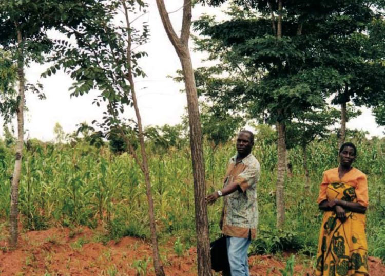
In many villages, HASHI field officers used residual natural seed and root stock to restore ngitili enclosures. In others, active tree planting (first of exotic species, later of the indigenous tree species preferred by local people) was carried out, especially around homesteads. Some of the restored ngitili dated back to pre-villagization days; others were newly created by farmers and villages. In addition to restoring ngitili, villagers were encouraged to plant trees around homesteads (particularly fruit and shade trees), field boundaries, and farm perimeters. This helped improve soil fertility and provide firewood, and had the side benefit of helping farmers to stake out and formalize their land rights within villages (Barrow 2005c).
Ecological Outcomes Achieved
Eliminate existing threats to the ecosystem:
In the early years, restoration efforts proceeded gradually, as cautious farmers and communities assessed the benefits and rights which ngitili regeneration produced. By the early 1990s, however, with the project's effectiveness beyond doubt, restoration efforts spread rapidly through the region. In 1986, only about 600 hectares of documented ngitili enclosures existed in Shinyanga. A survey of 172 sample villages in the late 1990s revealed 18,607 ngitili (284 communal and the rest owned by households) covering roughly 78,122 hectares (Kaale et al. 2003:8, Barrow and Mlenge 2004:1). Extrapolating from these figures, project managers estimate that more than 350,000 hectares in Shinyanga are in use as ngitili, with nine out of ten inhabitants of Shinyanga's 833 villages enjoying access to ngitili goods and services (Barrow 2005b).
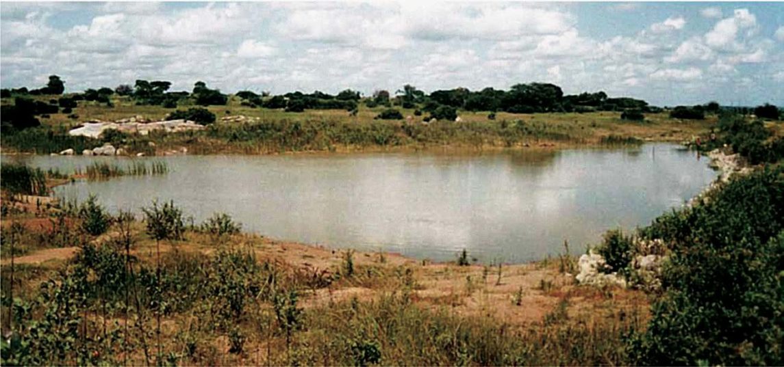
The case of Wigelekeko village, in the Maswa District of Shinyanga, demonstrates the implications of these new ngitilis for rural livelihoods and forest restoration. The village had suffered for years from shortages of animal fodder, wood products and water during the dry season. In 1986, with help from HASHI, the villagers set aside 160 hectares of severely degraded land as a ngitili. Domestic livestock were excluded from this area, and the natural vegetation was given time to recover. Five years later, the area was covered with dense scrub. Carefully controlled collection of firewood, thatching grass, medicinal plants and other forest products began in 1991. And then the water began to flow. A well that used to be empty in the dry season is now full throughout the year. Convinced that their efforts had increased the water supply, the villagers added another 20 hectares to the ngitili in 1997. Each family also contributed financially to the construction of a dam, which was filled with water from the ngitili. The villagers were even able to begin fishing, and the dam now provides water for almost 2000 cattle, with a surplus to sell to outsiders.
The ngitili forests were surveyed in 2004-2005, and a total of 152 different species of trees, shrubs and climbers were identified. There are variations in species composition between the districts, but two major vegetation types were distinguished, namely: Bushland (Acacia, Dalbergia , and Combretum bushlands) in Shinyanga Urban, Meatu, Bariadi and Maswa districts (eastern side of the region); and regrowth miombo woodland in Kahama, Shinyanga Rural and Bukombe districts (western side of the region). Generally, the regrowth miombo vegetation had higher stocking, basal area, volume production, and tree species diversity compared to the bushland.
Regeneration in the ngitilis was largely through coppice regrowth and root suckers, rather than through seeds. Regenerants are generally few, and the two most regenerating species, Dichrostachys cinerea and Omorcapum trichocarpum, are indicators of degraded areas. Grass and herb cover is also generally low and is dominated by grass species, which is another indicator of degraded sites. The dominant tree species in terms of volume per hectare in the surveyed ngitili are: Acacia tortilis, Acacia tanganyikensis, Acacia senegal, Acacia mellifera, Acacia kirkii, Acacia seyal var. fistula, Acacia drepanolobium, Acacia sieberiana, and Acacia polyacantha. Non-Acacia species included: Commiphora africana, Dalbergia melanoxylon, Combretum zeyheri, Cordia sinensis, Pterocarpus angolensis, Diplorhynchus condylocarpon and Albizia harveyi. Individual ngitili are well defined and of better quality in terms of wood stocking and tree species diversity when compared to communal ngitili.
Many species of birds and small- to medium-sized mammals have emerged after the introduction of the ngitili. Birds, mostly seed and insect eaters, have easily recolonised habitats that were once destroyed. There are 41 bird species with restricted ranges in Tanzania and seven of these species are found in the Shinyanga Region and its immediate environs. Bird species with restricted range in Shinyanga and its environs are Grey-breasted Spur fowl, Fischers Love Bird, Usambiro Barbet, Grey-chrested Helmet-Shrike, Rufous tailed Weaver and Steaky seed- eater.
Factors limiting recovery of the ecosystem:
There are not clear indications that the restoration is sustainable. Concerns have arisen due to the fact that both human and livestock populations are rapidly increasing, and there has been a surge in the demand for biodiversity resources from the recovering landscape.
Socio-Economic & Community Outcomes Achieved
Economic vitality and local livelihoods:
Armed with this powerful combination of traditional and scientific knowledge, villages across Shinyanga gradually revitalized the institution of ngitili and have broadened its use from simple soil and fodder conservation to production of a wide range of woodland goods and services. Products such as timber, fodder, fuelwood, medicinal herbs, wild fruits, honey, and edible insects have enhanced livelihoods and provided a vital safety net during dry seasons and droughts (Barrow and Mlenge 2003:1). The total monthly value of benefits from ngitilis per person in Shinyanga Region is estimated at Tsh. 14,046 (USD 14.0). This is higher than the national average consumption per person of Tsh. 8,500 (USD 8.5) per month in the rural areas of Tanzania.
Key Lessons Learned
Experience in Shinyanga illustrates the importance of working with local people. In the past, the state imposed its own solutions, which often failed. The survival rate of trees planted in state-sponsored communal wood lots, for example, was less than 20 per cent. The government’s HASHI project has not only involved local people in the whole process of landscape restoration, it has built on local institutions instead of creating new ones. Villages have been encouraged to pass their own by-laws to protect communal ngitilis, and traditional village guards monitor activities in the ngitilis. Allowing traditional Sukuma institutions and village governments to oversee restoration efforts has given villagers a sense of ownership and investment in the project’s outcome and has helped ensure region-wide success.
Long-Term Management
The project is ongoing.
Sources and Amounts of Funding
Funding for the HASHI project has been provided by the Government of the United Republic of Tanzania. Other donors include: United Nations Development Programme (UNDP), International Fund for Agricultural Development (IFAD), Norwegian Agency for Development Cooperation (NORAD), Oxford Famine (OXFAM), and World Conservation Union (IUCN).
Other Resources
Edmund Barrow
IUCN Eastern Africa Regional Office
P.O. Box 68200
Nairobi, Kenya
Tel: +254 2 890605
Fax: +254 2 890615
Email: [email protected]
Website: www.iucn.org/ourwork/earo.htm