Overview
The Cheverie Creek Salt Marsh Restoration Project began as a pilot project for the province of Nova Scotia and is the first such restoration effort to be undertaken there. Aiming to restore tidal flow to Cheverie Creek, project staff coordinated the replacement of an existing, undersized culvert in the Highway-215 causeway with a larger aluminum culvert that allows greater tidal flooding of the ecosystem. It is hoped that restoring the hydrologic integrity of the site will yield more vibrant bird and fish populations, more extensive salt-marsh vegetation, a decrease in the number of mosquitoes, and greater flushing of extant salt pannes. As this project is the first in Nova Scotia, project staff had to actively network with government agencies and other restoration practitioners in order to develop protocol, build relationships and garner support for future projects. Moreover, project staff worked closely with the local community and implemented a number of educational programs in order to inform the public about the importance of salt marsh ecosystems and directly involve them in the restoration process.
Quick Facts
Project Location:
Cheverie Creek , 45.157067, -64.1753109
Geographic Region:
North America
Country or Territory:
Canada
Biome:
Coastal/Marine
Ecosystem:
Estuaries, Marshes & Mangroves
Area being restored:
30 hectares
Project Lead:
The province of Nova Scotia
Organization Type:
Governmental Body
Location
Project Stage:
Completed
Start Date:
1999-07-03
End Date:
2005-12-03
Primary Causes of Degradation
Urbanization, Transportation & IndustryDegradation Description
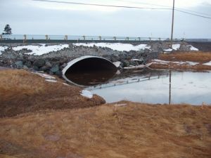
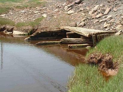
The salt marsh and tidal river system at the Cheverie Creek site was partially restricted by an undersized wooden culvert (1.5 m x 1 m) in the two-lane causeway (Highway 215) that crosses the mouth of the creek. Because this culvert was originally equipped with a clapper gate to prevent upstream tidal flow completely, trees, shrubs and other freshwater vegetation became established on much of the marsh’s surface. It is not known when or how the gate was removed, but one of the intense winter storms common to the area is thought to have been responsible. Even without the gate, though, the culvert was still too small to allow regular salt water flooding of the entire marsh, and partial obstruction by rocks and other roadway material further exacerbated the situation. Spring tides were restricted by as much as 1 meter, and tidal flooding was thus prevented for approximately 75% of the marsh area. These conditions resulted in the encroachment of freshwater vegetation, limited fish passage, loss of fish habitat, infrequent recharge of salt pannes (and a resultant rise in the mosquito population), risk of flooding during spring tides, erosion problems, and a safety hazard represented by strong currents and whirlpools at the mouth of the culvert.
Reference Ecosystem Description
Cheverie Creek is a wetland system encompassing approximately 70 acres and comprising a range of wetland habitat types–salt marsh, brackish, tidal fresh, fresh and upland edge. Cheverie Creek is predominantly high marsh, with the dominant species being Spartina patens (47% of total marsh area). Low marsh habitat is dominated by Spartina alterniflora (18% of total marsh area). A range of high-marsh and upland-edge plant species common to Fundy marshes are also present at Cheverie Creek, including Juncus geradii, Carex paleacea, Solidago sempervirens and Ammophila breviligulata. Furthermore, a number of brackish, freshwater and terrestrial plant species are also present (Tpyhaceae sp., Scirpus maritimus and Rubus strigosus).
Cheverie Creek provides important ecological niches for a variety of bird species. The tidal component of the system supports habitat for salt-marsh-dependent bird species such as Nelson’s Sharp-tailed Sparrow (Ammodramus nelsoni) and Willet (Catoptrophorus semipalmatus). During pre-restoration monitoring, twenty-eight species of waterfowl, shorebirds and wading birds were observed on the Cheverie Creek system. The birds most often observed were Semi-Palminated Sandpipers, Tree Swallows, and Nelson’s Sharp-tailed Sparrows. Other species included: American Black Duck, American Crow, American Goldfinch, American Robin, Bald Eagle, Black Capped Chickadee, Cedar Waxwing, Double-crested Cormorant, Eastern Blue Jay, European Starlings, Great Blue Heron, Greater and Lesser Yellowlegs, Kingfisher, Least Sandpipers, Merlin, Northern Flicker, Northern Harrier Hawk, Pileated Woodpecker, Red Winged Blackbird, Herring Gull, Solitary Sandpiper, and Yellow and Black Warblers.
Project Goals
The overarching goal of the Cheverie Creek Salt Marsh Restoration Project is to facilitate the restoration of a more natural tidal regime in a tidally-restricted marsh and wetland system. Other goals encompassed by this project are to galvanize the support of property owners and the local community for salt marsh restoration both at Cheverie Creek and at other sites in the area, and to develop collaborative relationships with regulatory agencies to promote and facilitate salt marsh restoration throughout Nova Scotia.
Monitoring
The project does not have a monitoring plan.
Stakeholders
The project staff worked closely with a steering committee comprised of representatives from the Nova Scotia Department of Natural Resources, the Department of Fisheries and Oceans, Mt. Allison University, the Nova Scotia Museum of Natural History, and the Ecology Action Centre. Efforts were made to involve community members throughout the project and to solicit feedback on such things as design considerations, effects of the culvert replacement on local land dynamics, and ecological changes that would likely result from the project. Communication methods included community meetings, letters to local residents, and written articles in local and provincial media sources.
Description of Project Activities:
Cheverie Creek was chosen as the site for this pilot project because a relatively large area of marsh habitat could be improved by means of a comparatively inexpensive culvert replacement. Furthermore, the area is ideal as a demonstration and learning site because it is located just across the highway from a popular picnic and viewing area and is, thus, easily accessed by the public.
Besides the project site, a reference site also had to be established to provide control data that would guide and elucidate post-restoration monitoring activities. Bass Creek, located approximately 5 km north of Cheverie in Bramber, is an unrestricted tidal river and salt marsh system that is also spanned by Highway 215. Unlike the crossing at Cheverie Creek, however, the Bass Creek crossing is a combination causeway-bridge structure, and the bridge spans the entire width of the main river channel. Hence, the data collected at Bass Creek allows for a comparison of the vegetation as well as the mosquito, bird, and fish populations in an unrestricted system versus a tidally-restricted one.
Before the replacement of the culvert could begin, baseline data had to be collected at Cheverie Creek in order to facilitate effective post-restoration monitoring of project results. Surveys of vegetation, hydrology, salinity, soil, sedimentation, groundwater, marsh elevation, and bird, fish, and mosquito populations were conducted in the summers of 2002, 2003 and 2004. Basic habitat mapping using a Global Positioning System (GPS) was also conducted. This data was collected by project staff, students, and volunteers from EAC and the local community, and it was used to develop a hydrology model to predict how the replacement of the culvert would affect the marsh and to provide a baseline for later comparison.
Project staff sought to build community support for the restoration by speaking with property owners, making presentations to community and environmental groups, leading marsh tours, conducting community meetings, publishing articles in local newspapers, creating information displays, providing regular community updates, and starting a partnership with a local school. EAC also worked to enhance community relations by lending its support to local organizations dealing with tangential issues such as bloodworm harvesting in the area. Other networking activities involved consulting and collaborating with salt marsh restorationists from around the Bay of Fundy and Gulf of Maine in order to ensure that the restoration efforts employed in this project conform to the research and monitoring standards in the region at large.
Construction on the new culvert began in December 2005 and was the last phase of the project. Hydrologic tidal modeling indicated that replacement of the existing tidal crossing with at least an 8-m by 3-m culvert would completely remove the restriction and allow 52% of tides to flood the majority of the marsh surface. Therefore, the existing wooden culvert was replaced by a 9.2-m by 5.5-m elliptical, aluminum culvert installed by Dexter Construction Limited through a Department of Transportation and Public Works (DOTPW) tender. This new culvert increased the opening approximately seven fold--from 4.7 m2 to 32.6 m2. An aluminum arch structure was chosen over concrete because of its long lifespan (an estimated 50-75 years), its superior resistance to salt water, and its relatively quick installation time.
Ecological Outcomes Achieved
Eliminate existing threats to the ecosystem:
Approximately 30 hectares of tidally restricted salt marsh habitat have benefited from the installation of the new culvert, and the community has now taken ownership over a planned education and interpretative centre. The recovery of Cheverie Creek is expected to take several years, and therefore the full extent of the project's success will only be ascertained with the realization of long-term monitoring activities.
Factors limiting recovery of the ecosystem:
Longer-term monitoring is needed in order to evaluate the site's recovery and determine what factors, if any, represent limits to restoration success.
Socio-Economic & Community Outcomes Achieved
Economic vitality and local livelihoods:
Salt marshes play a vital role in coastal ecosystem health. They help control coastal flooding and shoreline erosion, improve water quality, contribute significantly to coastal and marine food webs, and provide valuable habitat for fish, birds and other wildlife. They also reduce mosquitoes and the risk of flooding and provide neighboring communities with educational and recreational opportunities. We anticipate that the Cheverie Creek Salt Marsh Restoration Project will provide an excellent opportunity for the many visitors to the area (locals and tourists alike) to learn about the importance of salt marsh ecosystems and current efforts to protect and restore them.
Key Lessons Learned
One of the main contributions of this project has been to lay the groundwork for future restoration efforts by filling in some of the gaps in knowledge and skill currently existent in this field. There is a lack of data on the extent and condition of salt marshes and their potential for restoration; there is little information and technical expertise for salt marsh restoration in Canada; and there is a lack of clarity about the roles and responsibilities of practitioners and the regulations and permits pertaining to salt marsh restoration. With support and collaboration at all levels, project staff have made significant headway in addressing each of these challenges.
This project has also helped draw attention to the imperative for salt marsh restoration in the Bay of Fundy. When the project was begun, salt marsh restoration was not a major priority in Nova Scotia. However, the involvement of the EAC in this effort has raised the level of awareness and responsiveness to salt marsh restoration at all levels of government. The EAC has provided much needed information, technical support, training, contacts and coordination to facilitate future restoration projects in the Bay of Fundy. Entities such as the municipal council in West Hants, the provincial Department of Transportation and Public Works (DOTPW), and the Department of Fisheries and Oceans have started to institutionalize salt marsh protection and to incorporate salt marsh restoration into their planning. While sometimes it is frustrating when government takes over an idea, the kind of “mainstreaming” that has resulted from the work at Cheverie Creek is important for the long-term sustainability of the project and for the replicability of salt marsh restoration around the province.
Long-Term Management
Post-restoration monitoring is being conducted by CB Wetlands and Environmental Specialists and will last for five years. The focus of this monitoring will be on the physical and biological components of the Cheverie Creek system (both before and after restoration), as well as those of the Bass Creek reference site, in order to record ecological changes and habitat/species responses to restoration.
Other Resources
Ecology Action Center
1568 Argyle Street, Suite 31
Halifax, Nova Scotia
Canada, B3J 2B3
902/429-2202
URL: http://ecologyaction.ca
Email: [email protected]
Gulf of Maine Council on the Marine Environment
URL: http://www.gulfofmaine.org/